FAA INFORMATION EFFECTIVE 30 OCTOBER 2025
Location
| FAA Identifier: | 5C8 |
| Lat/Long: | 47-21-04.1360N 101-01-33.2260W
47-21.068933N 101-01.553767W
47.3511489,-101.0258961
(estimated) |
| Elevation: | 1908 ft. / 581.6 m (surveyed) |
| Variation: | 10E (1985) |
| From city: | 4 miles N of WASHBURN, ND |
| Time zone: | UTC -6 (UTC -5 during Daylight Saving Time) |
| Zip code: | 58577 |
Airport Operations
| Airport use: | Open to the public |
| Activation date: | 12/1943 |
| Control tower: | no |
| ARTCC: | MINNEAPOLIS CENTER |
| FSS: | GRAND FORKS FLIGHT SERVICE STATION |
| NOTAMs facility: | GFK (NOTAM-D service available) |
| Attendance: | UNATNDD |
| Wind indicator: | lighted |
| Segmented circle: | yes |
| Lights: | ACTVT PAPI RWY 08 & 26; MIRL RWY 08/26 - CTAF. LOW INTST NOT AVBL. |
| Beacon: | white-green (lighted land airport)
Operates sunset to sunrise. |
Airport Communications
Nearby radio navigation aids
| VOR radial/distance | | VOR name | | Freq | | Var |
|---|
| BISr325/38.3 | | BISMARCK VOR/DME | | 115.65 | | 12E |
Airport Services
| Fuel available: | 100LL
100LL:24HR SELF-SERVICE FUEL AVBL WITH CREDIT CARD. |
| Parking: | tiedowns |
| Airframe service: | NONE |
| Powerplant service: | NONE |
| Bottled oxygen: | NONE |
| Bulk oxygen: | NONE |
Runway Information
Runway 8/26
| Dimensions: | 3700 x 60 ft. / 1128 x 18 m |
| Surface: | concrete, in good condition |
| Runway edge lights: | medium intensity |
| RUNWAY 8 | | RUNWAY 26 |
| Latitude: | 47-21.005825N | | 47-21.004792N |
| Longitude: | 101-02.022315W | | 101-01.126860W |
| Elevation: | 1907.0 ft. | | 1907.4 ft. |
| Traffic pattern: | left | | left |
| Runway heading: | 080 magnetic, 090 true | | 260 magnetic, 270 true |
| Markings: | nonprecision, in fair condition | | nonprecision, in fair condition |
| Visual slope indicator: | 2-light PAPI on left (3.00 degrees glide path) | | 2-light PAPI on left (3.00 degrees glide path) |
| Touchdown point: | yes, no lights | | yes, no lights |
| Obstructions: | 11 ft. road, 485 ft. from runway, 155 ft. left and right of centerline, 26:1 slope to clear | | none |
Runway 17/35
| Dimensions: | 2204 x 135 ft. / 672 x 41 m |
| Surface: | turf, in fair condition |
| Runway edge markings: | RY 17/35 MKD WITH DALGT BOUNDARY MARKERS; BLACK/WHITE CONES. |
| Operational restrictions: | CLSD WINTER MONTHS DUE TO LACK OF SNOW REMOVAL. |
| RUNWAY 17 | | RUNWAY 35 |
| Latitude: | 47-21.356988N | | 47-20.994508N |
| Longitude: | 101-01.518203W | | 101-01.519457W |
| Elevation: | 1903.9 ft. | | 1906.4 ft. |
| Traffic pattern: | left | | left |
| Runway heading: | 170 magnetic, 180 true | | 350 magnetic, 000 true |
| Runway end identifier lights: | no | | no |
| Touchdown point: | yes, no lights | | yes, no lights |
| Obstructions: | 16 ft. road, 334 ft. from runway, 160 ft. left and right of centerline, 20:1 slope to clear | | none
+150 FT EAST-WEST TRANSMISSION LINE 9500' SOUTH ON EXTNDD CNTRLN. |
Airport Ownership and Management from official FAA records
| Ownership: | Publicly-owned |
| Owner: | WASHBURN AIRPORT AUTHORITY
BOX 403
WASHBURN, ND 58577
Phone (701) 390-3926 |
| Manager: | LYLE LELM
BOX 403
WASHBURN, ND 58577
Phone 701-390-3926 |
Additional Remarks
| - | +700' SMOKE STACK OF POWER PLANT LOCATED 6 MI WNW OF ARPT. |
| - | WATERFOWL,BLACKBIRDS, DEER AND ANTELOPE ON AND INVOF OF ARPT. |
| - | CONFIRM WINTER CONDITIONS WITH ARPT MGR AFTER MAJOR STORM PRIOR TO USE - SNOW REMOVAL IRREGULAR SCHEDULE. |
| - | FOR CD CTC MINNEAPOLIS ARTCC AT 651-463-5588. |
Instrument Procedures
There are no published instrument procedures at 5C8.
Some nearby airports with instrument procedures:
KHZE - Mercer County Regional Airport (23 nm W)
D05 - Garrison Municipal Airport (25 nm NW)
Y19 - Mandan Regional Airport/Lawler Field (35 nm S)
KBIS - Bismarck Municipal Airport (37 nm S)
D57 - Glen Ullin Regional Airport (47 nm SW)
|
|

Road maps at:
MapQuest
Bing
Google
| Aerial photo |
|---|
WARNING: Photo may not be current or correct

Do you have a better or more recent aerial photo of Washburn Municipal Airport that you would like to share? If so, please send us your photo.
|
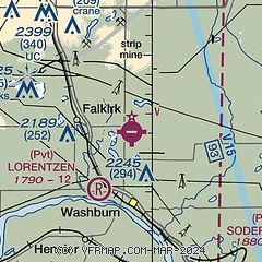
| Sectional chart |
|---|
|
| Airport distance calculator |
|---|
|
|
| Sunrise and sunset |
|---|
|
Times for 26-Nov-2025
| | Local
(UTC-6) | | Zulu
(UTC) |
|---|
| Morning civil twilight | | 07:31 | | 13:31 |
| Sunrise | | 08:05 | | 14:05 |
| Sunset | | 16:58 | | 22:58 |
| Evening civil twilight | | 17:32 | | 23:32 |
|
| Current date and time |
|---|
| Zulu (UTC) | 27-Nov-2025 01:47:43 |
|---|
| Local (UTC-6) | 26-Nov-2025 19:47:43 |
|---|
|
| METAR |
|---|
KHZE
23nm W | 270135Z AUTO 23006KT 1/4SM FZFG M08/M09 A3036 RMK AO2
|
KN60
24nm NW | 270054Z AUTO 33005KT M09/M11 A3032 RMK AO1 SLP310 T10941106
|
KY19
35nm S | 270135Z AUTO 34004KT M1/4SM FZFG M10/M10 A3034 RMK AO2
|
KBIS
37nm S | 270135Z AUTO 30006KT 1 3/4SM BR OVC004 M09/M09 A3036 RMK AO2 I1000 T10891094
|
|
| TAF |
|---|
KBIS
37nm S | 261733Z 2618/2718 26004KT P6SM SKC FM270300 31003KT 4SM BR SCT004 FM270400 31003KT 1SM BR BKN004 FM270900 32004KT 6SM BR BKN002
|
|
| NOTAMs |
|---|
NOTAMs are issued by the DoD/FAA and will open in a separate window not controlled by AirNav.
|
|

