FAA INFORMATION EFFECTIVE 11 JUNE 2026
Location
| FAA Identifier: | 5F4 |
| Lat/Long: | 32-47-18.6000N 093-00-13.1190W
32-47.310000N 093-00.218650W
32.7885000,-93.0036442
(estimated) |
| Elevation: | 244.1 ft. / 74.4 m (surveyed) |
| Variation: | 02E (2005) |
| From city: | 3 miles E of HOMER, LA |
| Time zone: | UTC -5 (UTC -6 during Standard Time) |
| Zip code: | 71040 |
Airport Operations
| Airport use: | Open to the public |
| Activation date: | 01/1970 |
| Control tower: | no |
| ARTCC: | FORT WORTH CENTER |
| FSS: | DE RIDDER FLIGHT SERVICE STATION |
| NOTAMs facility: | DRI (NOTAM-D service available) |
| Attendance: | UNATNDD |
| Wind indicator: | lighted |
| Segmented circle: | yes |
| Lights: | REIL RWY 12/30; MIRL RWY 12/30 PRESET LOW INTST DUSK-DAWN; TO INCR INTST ACTVT - CTAF. |
| Beacon: | white-green (lighted land airport)
Operates sunset to sunrise. |
Airport Communications
| CTAF: | 122.9 |
| WX AWOS-3PT at MNE (17 nm SW): | 119.325 (318-371-7874) |
Nearby radio navigation aids
| VOR radial/distance | | VOR name | | Freq | | Var |
|---|
| ELDr198/31.0 | | EL DORADO VOR/DME | | 115.50 | | 07E |
| EMGr045/37.9 | | ELM GROVE VORTAC | | 116.65 | | 07E |
Airport Services
Runway Information
Runway 12/30
| Dimensions: | 3200 x 60 ft. / 975 x 18 m |
| Surface: | asphalt, in good condition
EXCESSIVE RWY EDGE LIPS EXIST AFTER OVERLAY PROJECT. PILOTS ARE CAUTIONED TO STAY IN THE CTR OF THE RWY & TWY. |
| Weight bearing capacity: | |
| Runway edge lights: | medium intensity |
| RUNWAY 12 | | RUNWAY 30 |
| Latitude: | 32-47.451785N | | 32-47.168210N |
| Longitude: | 093-00.482088W | | 092-59.955230W |
| Elevation: | 244.0 ft. | | 228.2 ft. |
| Traffic pattern: | left | | left |
| Runway heading: | 120 magnetic, 122 true | | 300 magnetic, 302 true |
| Markings: | basic, in good condition | | basic, in good condition |
| Runway end identifier lights: | yes | | yes |
| Touchdown point: | yes, no lights | | yes, no lights |
| Obstructions: | 63 ft. trees, 356 ft. from runway, 183 ft. left of centerline, 2:1 slope to clear | | 66 ft. trees, 461 ft. from runway, 283 ft. right of centerline, 3:1 slope to clear |
Airport Ownership and Management from official FAA records
| Ownership: | Publicly-owned |
| Owner: | CITY OF HOMER
400 EAST MAIN
HOMER, LA 71040
Phone 318-927-3555 |
| Manager: | JERRY WHITTON
550 AIRPORT LOOP, FIRE STATION
HOMER, LA 71040
Phone 318-225-0911 |
Additional Remarks
| - | FOR CD CTC FORT WORTH ARTCC AT 817-858-7584. |
| - | CTC APRT MGR FOR DSGND RAMP SPACE FOR PUB USE. |
Instrument Procedures
There are no published instrument procedures at 5F4.
Some nearby airports with instrument procedures:
KMNE - Minden Airport (17 nm SW)
KSPH - Springhill Airport (24 nm NW)
KRSN - Ruston Regional Airport (27 nm SE)
KELD - South Arkansas Regional Airport at Goodwin Field (28 nm N)
KAGO - Ralph C Weiser Field Airport (28 nm N)
|
|

Road maps at:
MapQuest
Bing
Google
| Aerial photo |
|---|
WARNING: Photo may not be current or correct
 Photo by Mark Burns
Photo taken 01-May-2006
Photo by Mark Burns
Photo taken 01-May-2006
Do you have a better or more recent aerial photo of Homer Municipal Airport that you would like to share? If so, please send us your photo.
|
| Sectional chart |
|---|
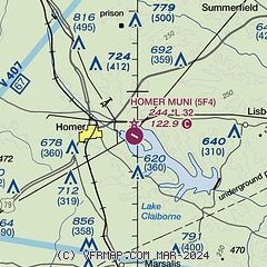
|
| Airport distance calculator |
|---|
|
|
| Sunrise and sunset |
|---|
|
Times for 21-Jun-2026
| | Local
(UTC-5) | | Zulu
(UTC) |
|---|
| Morning civil twilight | | 05:37 | | 10:37 |
| Sunrise | | 06:05 | | 11:05 |
| Sunset | | 20:22 | | 01:22 |
| Evening civil twilight | | 20:51 | | 01:51 |
|
| Current date and time |
|---|
| Zulu (UTC) | 21-Jun-2026 06:08:33 |
|---|
| Local (UTC-5) | 21-Jun-2026 01:08:33 |
|---|
|
| METAR |
|---|
KMNE
17nm SW | 210555Z AUTO 10SM CLR 24/22 A2991 RMK AO2
|
KRSN
27nm SE | 210555Z AUTO 13005KT 10SM BKN004 23/23 A2991 RMK AO2 60001 T02330233 10297 20233 403020209 55006 $
|
KELD
27nm N | 210553Z AUTO 14005KT 10SM CLR 24/23 A2989 RMK AO2 SLP118 T02390228 10294 20239 403170217 58008 $
|
KAGO
28nm N | 210555Z AUTO 00000KT 10SM CLR 24/23 A2987 RMK A01
|
|
| TAF |
|---|
KELD
27nm N | 210540Z 2106/2206 15004KT P6SM SKC FM211200 16005KT 6SM BR BKN015 FM211500 18019KT P6SM BKN023 FM211700 19010KT P6SM BKN035 FM211900 20011G19KT P6SM VCTS BKN035CB FM212200 19010KT P6SM SCT040 SCT090 BKN250 FM220100 17008KT P6SM FEW040 SCT250
|
|
| NOTAMs |
|---|
NOTAMs are issued by the DoD/FAA and will open in a separate window not controlled by AirNav.
|
|

