FAA INFORMATION EFFECTIVE 11 JUNE 2026
Location
| FAA Identifier: | 6W0 |
| Lat/Long: | 39-24-22.0000N 080-16-36.7000W
39-24.366667N 080-16.611667W
39.4061111,-80.2768611
(estimated) |
| Elevation: | 997 ft. / 304 m (estimated) |
| Variation: | 07W (1985) |
| From city: | 1 mile NE of SHINNSTON, WV |
| Time zone: | UTC -4 (UTC -5 during Standard Time) |
| Zip code: | 26431 |
Airport Operations
| Airport use: | Open to the public |
| Activation date: | 03/1983 |
| Control tower: | no |
| ARTCC: | CLEVELAND CENTER |
| FSS: | ELKINS FLIGHT SERVICE STATION [703-724-4288] |
| NOTAMs facility: | EKN (NOTAM-D service available) |
| Attendance: | UNATNDD |
| Wind indicator: | yes |
| Segmented circle: | no |
Airport Communications
| CTAF: | 122.9 |
| WX ASOS at CKB (7 nm S): | PHONE 304-842-9240 |
Nearby radio navigation aids
| VOR radial/distance | | VOR name | | Freq | | Var |
|---|
| CKBr001/9.2 | | CLARKSBURG VOR/DME | | 112.60 | | 04W |
| MGWr250/21.3 | | MORGANTOWN VOR/DME | | 111.60 | | 05W |
| EKNr351/30.6 | | ELKINS VORTAC | | 114.20 | | 07W |
| NDB name | | Hdg/Dist | | Freq | | Var | | ID |
|---|
| RANDOLPH COUNTY | | 335/36.4 | | 284 | | 07W | | RQY | .-. --.- -.-- |
Airport Services
| Parking: | tiedowns |
| Airframe service: | MINOR |
| Powerplant service: | MINOR |
Runway Information
Runway 5/23
| Dimensions: | 2265 x 45 ft. / 690 x 14 m |
| Surface: | turf, in good condition |
| RUNWAY 5 | | RUNWAY 23 |
| Latitude: | 39-24.217900N | | 39-24.514078N |
| Longitude: | 080-16.757532W | | 080-16.464860W |
| Elevation: | 977.0 ft. | | 997.0 ft. |
| Traffic pattern: | left | | right |
| Runway heading: | 044 magnetic, 037 true | | 224 magnetic, 217 true |
| Obstructions: | 80 ft. trees, 150 ft. from runway, 125 ft. right of centerline, 1:1 slope to clear
450 FT HILL, 1/4 MILE NE. | | 25 ft. gnd, 120 ft. right of centerline |
Airport Ownership and Management from official FAA records
| Ownership: | Privately-owned |
| Owner: | WOODY MALEY
1291 LANDING WAY
SHINNSTON, WV 26431-7447
Phone 304-641-8406 |
| Manager: | WOODY MALEY
1291 LANDING WAY
SHINNSTON, WV 26431-7447
Phone 304-641-8406
ALTERNATE PH 304-592-2400. |
Additional Remarks
| - | 15 FT DROP-OFF 45 FT FM CNTRLN FULL LENGTH BOTH SIDES RWY. |
| - | ACFT PARKED 55 FT W OF RWY CNTRLN, APRXLY 1000 FT N OF RWY 5 END. |
| - | FOR CD CTC CLARKSBURG APCH AT 304-842-2011, WHEN APCH CLSD CTC CLEVELAND ARTCC AT 440-774-0226. |
| - | POWER PLANT - 2 STACKS, 1979 MSL, 1009 AGL, 3 MI SW. |
| - | APPROACH RWY 23 FROM NW; DEPART RWY 05 TO NW DUE TO RIDGE NE OF ARPT. |
| - | DEER ON & INVOF ARPT. |
| - | RWY 23: 15 FT DROP-OFF 10 FT FM THLD OB. |
| - | RWY 05: 20 FT DROP-OFF 15 FT FM THLD OB. |
| - | RWY 05/23, 20 FT PWR POLES MIDPT OF RWY, 65 FT L & R OF CNTRLN. |
| - | 400 FT RIDGE/TREES 1100 FT FM THLD RY 23 0B. |
| - | HIGH TERRAIN ALL QUADRANTS. |
Instrument Procedures
There are no published instrument procedures at 6W0.
Some nearby airports with instrument procedures:
4G7 - Fairmont Municipal Airport-Frankman Field (6 nm NE)
KCKB - North Central West Virginia Airport (7 nm S)
79D - Philippi/Barbour County Regional Airport (18 nm SE)
KMGW - Morgantown Municipal Airport/Walter L Bill Hart Field (22 nm NE)
W22 - Upshur County Regional Airport (24 nm S)
|
|

Road maps at:
MapQuest
Bing
Google
| Aerial photo |
|---|

|
| Sectional chart |
|---|
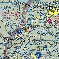
|
| Airport distance calculator |
|---|
|
|
| Sunrise and sunset |
|---|
|
Times for 21-Jun-2026
| | Local
(UTC-4) | | Zulu
(UTC) |
|---|
| Morning civil twilight | | 05:23 | | 09:23 |
| Sunrise | | 05:55 | | 09:55 |
| Sunset | | 20:50 | | 00:50 |
| Evening civil twilight | | 21:23 | | 01:23 |
|
| Current date and time |
|---|
| Zulu (UTC) | 21-Jun-2026 09:57:48 |
|---|
| Local (UTC-4) | 21-Jun-2026 05:57:48 |
|---|
|
| METAR |
|---|
KCKB
7nm SE | 210953Z AUTO 00000KT 1 3/4SM BR CLR 14/14 A2996 RMK AO2 VIS 1/2V5 SLP135 T01390139
|
|
| TAF |
|---|
KCKB
7nm SE | 210520Z 2106/2206 25006KT P6SM VCSH SCT060 TEMPO 2106/2107 4SM -SHRA BR BKN035 FM210700 00000KT 6SM BR SCT001 FM211200 VRB05KT P6SM SCT200 FM212100 VRB03KT P6SM BKN170
|
|
| NOTAMs |
|---|
NOTAMs are issued by the DoD/FAA and will open in a separate window not controlled by AirNav.
|
|

