FAA INFORMATION EFFECTIVE 18 APRIL 2024
Location
| FAA Identifier: | 78R |
| Lat/Long: | 31-32-25.5500N 094-10-12.2400W
31-32.425833N 094-10.204000W
31.5404306,-94.1700667
(estimated) |
| Elevation: | 443 ft. / 135.0 m (surveyed) |
| Variation: | 05E (1985) |
| From city: | 3 miles W of SAN AUGUSTINE, TX |
| Time zone: | UTC -5 (UTC -6 during Standard Time) |
| Zip code: | 75972 |
Airport Operations
| Airport use: | Open to the public |
| Activation date: | 06/1970 |
| Control tower: | no |
| ARTCC: | HOUSTON CENTER |
| FSS: | MONTGOMERY COUNTY FLIGHT SERVICE STATION |
| NOTAMs facility: | CXO (NOTAM-D service available) |
| Attendance: | UNATNDD |
| Wind indicator: | lighted |
| Segmented circle: | yes |
| Lights: | MIRL RY 17/35 PRESET LOW INTST, TO INCR INTST ACTVT - CTAF. |
| Beacon: | white-green (lighted land airport)
ACTVT ROTG BCN - CTAF. |
Airport Communications
| CTAF: | 122.9 |
| WX AWOS-3PT at F17 (17 nm N): | 128.775 (936-598-3355) |
Nearby radio navigation aids
| VOR radial/distance | | VOR name | | Freq | | Var |
|---|
| LFKr046/36.0 | | LUFKIN VORTAC | | 112.10 | | 05E |
| NDB name | | Hdg/Dist | | Freq | | Var | | ID |
|---|
| AMASON | | 179/17.6 | | 341 | | 04E | | CZJ | -.-. --.. .--- |
Airport Services
| Airframe service: | NONE |
| Powerplant service: | NONE |
| Bottled oxygen: | NONE |
| Bulk oxygen: | NONE |
Runway Information
Runway 17/35
| Dimensions: | 3800 x 50 ft. / 1158 x 15 m |
| Surface: | asphalt, in poor condition
CRACKING & FEW POTHOLES. |
| Weight bearing capacity: | |
| Runway edge lights: | medium intensity |
| RUNWAY 17 | | RUNWAY 35 |
| Latitude: | 31-32.739167N | | 31-32.112500N |
| Longitude: | 094-10.206667W | | 094-10.201333W |
| Elevation: | 443.0 ft. | | 393.0 ft. |
| Traffic pattern: | left | | left |
| Runway heading: | 175 magnetic, 180 true | | 355 magnetic, 360 true |
| Displaced threshold: | 124 ft. | | no |
| Markings: | basic, in fair condition | | basic, in fair condition |
| Obstructions: | 43 ft. trees, 363 ft. from runway, 3:1 slope to clear
10 FT BRUSH, 130 FT DSTC, 113 FT R. | | 95 ft. trees, 570 ft. from runway, 180 ft. right of centerline, 3:1 slope to clear |
Airport Ownership and Management from official FAA records
| Ownership: | Publicly-owned |
| Owner: | SAN AUGUSTINE COUNTY
100 W. COLUMBIA ST, ROOM 105
SAN AUGUSTINE, TX 75972
Phone 936-275-2762 |
| Manager: | JEFF BOYD
100 W. COLUMBIA
SAN AUGUSTINE, TX 75972
Phone 936-275-2762
EMERG PHONE: 936-275-2424, SHERIFF OFC. |
Airport Operational Statistics
| Aircraft based on the field: | | 1 | | Single engine airplanes: | | 1 |
| |  | |
| Aircraft operations: 100/year * | | 100% | transient general aviation | | * for 12-month period ending 06 October 2022 | |
Additional Remarks
| - | FOR CD CTC HOUSTON ARTCC AT 281-230-5622. |
Instrument Procedures
There are no published instrument procedures at 78R.
Some nearby airports with instrument procedures:
F17 - Center Municipal Airport (17 nm N)
KOCH - Nacogdoches A L Mangham Jr. Regional Airport (28 nm W)
KLFK - Angelina County Airport (35 nm SW)
3R4 - Hart Airport (35 nm E)
3F3 - C E 'Rusty' Williams Airport (38 nm NE)
|
|

Road maps at:
MapQuest
Bing
Google
| Aerial photo |
|---|
WARNING: Photo may not be current or correct

Do you have a better or more recent aerial photo of San Augustine County Airport that you would like to share? If so, please send us your photo.
|
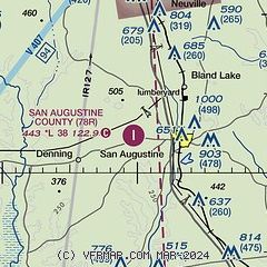
| Sectional chart |
|---|
|
| Airport distance calculator |
|---|
|
|
| Sunrise and sunset |
|---|
|
Times for 23-Apr-2024
| | Local
(UTC-5) | | Zulu
(UTC) |
|---|
| Morning civil twilight | | 06:14 | | 11:14 |
| Sunrise | | 06:39 | | 11:39 |
| Sunset | | 19:50 | | 00:50 |
| Evening civil twilight | | 20:16 | | 01:16 |
|
| Current date and time |
|---|
| Zulu (UTC) | 23-Apr-2024 18:53:02 |
|---|
| Local (UTC-5) | 23-Apr-2024 13:53:02 |
|---|
|
| METAR |
|---|
KF17
17nm N | 231835Z AUTO 18005KT 10SM CLR 23/08 A3009 RMK AO2
|
KOCH
28nm W | 231756Z AUTO 17008KT 10SM CLR 23/12 A3010 RMK AO2 SLP197 T02280122 10233 20072 58014
|
KLFK
35nm SW | 231753Z AUTO 16010G18KT 10SM CLR 23/14 A3010 RMK AO2 SLP190 T02330139 10233 20089 58012
|
|
| TAF |
|---|
KLFK
35nm SW | 231728Z 2318/2418 18011G17KT P6SM SCT045 FM240000 16007KT P6SM BKN040 BKN120 FM240900 13004KT 6SM BR BKN015 FM241200 17005KT 4SM BR OVC007 FM241700 18005KT P6SM OVC020
|
|
| NOTAMs |
|---|
NOTAMs are issued by the DoD/FAA and will open in a separate window not controlled by AirNav.
|
|

