FAA INFORMATION EFFECTIVE 04 SEPTEMBER 2025
Location
| FAA Identifier: | 7W1 |
| Lat/Long: | 46-18-53.6850N 124-00-13.8170W
46-18.894750N 124-00.230283W
46.3149125,-124.0038381
(estimated) |
| Elevation: | 13 ft. / 4 m (estimated) |
| Variation: | 20E (1985) |
| From city: | 2 miles E of ILWACO, WA |
| Time zone: | UTC -7 (UTC -8 during Standard Time) |
| Zip code: | 98624 |
Airport Operations
| Airport use: | Open to the public |
| Activation date: | 08/1937 |
| Control tower: | no |
| ARTCC: | SEATTLE CENTER |
| FSS: | SEATTLE FLIGHT SERVICE STATION |
| NOTAMs facility: | SEA (NOTAM-D service available) |
| Attendance: | UNATNDD |
| Wind indicator: | lighted |
| Segmented circle: | no |
| Beacon: | white-green (lighted land airport)
ARPT BEACON PILOT ACTIVATED. |
Airport Communications
| CTAF: | 122.9 |
| WX ASOS at AST (11 nm SE): | 135.375 (503-994-0014) |
Nearby radio navigation aids
| VOR radial/distance | | VOR name | | Freq | | Var |
|---|
| ASTr316/10.5 | | ASTORIA VOR/DME | | 114.00 | | 15E |
| HQMr152/38.4 | | HOQUIAM VORTAC | | 117.70 | | 19E |
Airport Services
| Parking: | tiedowns |
| Airframe service: | NONE |
| Powerplant service: | NONE |
| Bottled oxygen: | NONE |
| Bulk oxygen: | NONE |
Runway Information
Runway 10/28
| Dimensions: | 2080 x 50 ft. / 634 x 15 m |
| Surface: | asphalt, in good condition |
| Weight bearing capacity: | | Single wheel: | 5.0, FULL STRENGTH PAVEMENT CENTER 30' ONLY. |
|
| Runway edge markings: | MARKINGS FADED. |
| RUNWAY 10 | | RUNWAY 28 |
| Latitude: | 46-18.979667N | | 46-18.809833N |
| Longitude: | 124-00.444650W | | 124-00.015933W |
| Traffic pattern: | left | | left |
| Runway heading: | 100 magnetic, 120 true | | 280 magnetic, 300 true |
| Displaced threshold: | no | | 300 ft. |
| Markings: | basic, in poor condition | | basic, in poor condition |
| Visual slope indicator: | | | 2-light PAPI on left (4.00 degrees glide path) |
| Obstructions: | 46 ft. trees, 300 ft. from runway, 88 ft. right of centerline, 2:1 slope to clear
15 FT ROAD & 2 FT FENCE, 0-200 FT FM END, 50 FT-125 FT R. | | 45 ft. trees, 562 ft. from runway, 59 ft. right of centerline, 8:1 slope to clear
RWY 28 15 FT ROAD 0-200 FT DIST 60 FT L. 2 FT FENCE & 6 FT SIGN 76 FT R & 135 FT FM THR. |
Airport Ownership and Management from official FAA records
| Ownership: | Publicly-owned |
| Owner: | PORT OF ILWACO
165 HOWERTON WAY, PO BOX 307
ILWACO, WA 98624
Phone 360-642-3143 |
| Manager: | TRACY LOFSTROM
PORT OF ILWACO 165 HOWERTON AVENUE, PO BOX 307
ILWACO, WA 98624
Phone 360-642-3143 |
Additional Remarks
| - | FOR CD CTC SEATTLE ARTCC AT 253-351-3694. |
Instrument Procedures
There are no published instrument procedures at 7W1.
Some nearby airports with instrument procedures:
KAST - Astoria Regional Airport (11 nm SE)
KHQM - Bowerman Field Airport (39 nm N)
KKLS - Southwest Washington Regional Airport (47 nm E)
KCLS - Chehalis-Centralia Airport (47 nm NE)
KTDO - Ed Carlson Memorial Field/South Lewis County Airport (50 nm E)
|
|

Road maps at:
MapQuest
Bing
Google
| Aerial photo |
|---|
WARNING: Photo may not be current or correct
 Photo by Frank Wolfe
Taken in October 2005
Photo by Frank Wolfe
Taken in October 2005
Do you have a better or more recent aerial photo of Port of Ilwaco Airport that you would like to share? If so, please send us your photo.
|
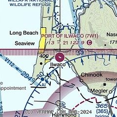
| Sectional chart |
|---|
|
| Airport distance calculator |
|---|
|
|
| Sunrise and sunset |
|---|
|
Times for 19-Sep-2025
| | Local
(UTC-7) | | Zulu
(UTC) |
|---|
| Morning civil twilight | | 06:30 | | 13:30 |
| Sunrise | | 07:00 | | 14:00 |
| Sunset | | 19:19 | | 02:19 |
| Evening civil twilight | | 19:49 | | 02:49 |
|
| Current date and time |
|---|
| Zulu (UTC) | 19-Sep-2025 09:50:15 |
|---|
| Local (UTC-7) | 19-Sep-2025 02:50:15 |
|---|
|
| METAR |
|---|
KAST
11nm SE | 190928Z AUTO 15003KT 9SM BKN006 09/08 A2999 RMK AO2 T00890083
|
|
| TAF |
|---|
KAST
11nm SE | 190520Z 1906/2006 31009G19KT P6SM SKC FM191900 32007KT P6SM SKC FM200300 30005KT P6SM SKC
|
|
| NOTAMs |
|---|
NOTAMs are issued by the DoD/FAA and will open in a separate window not controlled by AirNav.
|
|

