FAA INFORMATION EFFECTIVE 11 JUNE 2026
Location
| FAA Identifier: | 81D |
| Lat/Long: | 29-15-53.8818N 095-24-45.2522W
29-15.898030N 095-24.754203W
29.2649672,-95.4125701
(estimated) |
| Elevation: | 30 ft. / 9 m (estimated) |
| Variation: | 06E (1985) |
| From city: | 6 miles N of ANGLETON, TX |
| Time zone: | UTC -5 (UTC -6 during Standard Time) |
| Zip code: | 77515 |
Airport Operations
| Airport use: | Open to the public |
| Activation date: | 01/1987 |
| Control tower: | no |
| ARTCC: | HOUSTON CENTER |
| FSS: | MONTGOMERY COUNTY FLIGHT SERVICE STATION |
| NOTAMs facility: | CXO (NOTAM-D service available) |
| Attendance: | UNATNDD |
| Wind indicator: | yes |
| Segmented circle: | no |
Airport Communications
| CTAF: | 122.9 |
| WX ASOS at LBX (10 nm S): | 119.925 (979-849-3319) |
| WX AWOS-3 at AXH (15 nm N): | 123.625 (281-431-6572) |
| WX ASOS at LVJ (18 nm NE): | 118.525 (281-992-1853) |
Nearby radio navigation aids
| VOR radial/distance | | VOR name | | Freq | | Var |
|---|
| VUHr263/28.5 | | SCHOLES VOR/DME | | 113.00 | | 06E |
| MHFr237/38.6 | | TRINITY VOR/DME | | 114.75 | | 07E |
Airport Services
Runway Information
Runway 16/34
| Dimensions: | 2261 x 90 ft. / 689 x 27 m |
| Surface: | turf, in good condition |
| RUNWAY 16 | | RUNWAY 34 |
| Latitude: | 29-16.076167N | | 29-15.718167N |
| Longitude: | 095-24.851167W | | 095-24.728667W |
| Elevation: | 34.0 ft. | | 30.0 ft. |
| Traffic pattern: | left | | left |
| Runway heading: | 157 magnetic, 163 true | | 337 magnetic, 343 true |
| Obstructions: | 15 ft. road, 18 ft. from runway, 125 ft. left and right of centerline, 1:1 slope to clear | | 60 ft. trees, 20 ft. from runway, 125 ft. left and right of centerline |
Runway 17/35
| Dimensions: | 2200 x 80 ft. / 671 x 24 m |
| Surface: | turf, in good condition |
| RUNWAY 17 | | RUNWAY 35 |
| Latitude: | 29-16.080333N | | 29-15.717500N |
| Longitude: | 095-24.724000W | | 095-24.711000W |
| Elevation: | 34.0 ft. | | 30.0 ft. |
| Traffic pattern: | left | | left |
| Runway heading: | 172 magnetic, 178 true | | 352 magnetic, 358 true |
| Obstructions: | 15 ft. road, 19 ft. from runway, 125 ft. left and right of centerline, 1:1 slope to clear | | 60 ft. trees, 20 ft. from runway, 125 ft. left and right of centerline |
Airport Ownership and Management from official FAA records
| Ownership: | Privately-owned |
| Owner: | BRIAN BOHANNON
2720 COUNTY ROAD 49
ANGLETON, TX 77515
Phone 281-731-1231 |
| Manager: | BRIAN BOHANNON
2720 COUNTY ROAD 49
ANGLETON, TX 77515
Phone 281-731-1231 |
Additional Remarks
| - | POWER LINES BURIED IN RWYS 16 & 17 APCH. |
| - | RWY 16/34, 3 FT BERM AT SOUTH TH. |
| - | RWY 16 & RWY 17, 15 FT RD ACRS RWY END. |
| - | FOR CD CTC HOUSTON APCH AT 281-443-5844 TO CNL IFR CALL 281-443-5888. |
Instrument Procedures
There are no published instrument procedures at 81D.
Some nearby airports with instrument procedures:
KLBX - Texas Gulf Coast Regional Airport (10 nm S)
KAXH - Houston Southwest Airport (15 nm N)
KLVJ - Pearland Regional Airport (18 nm NE)
KHOU - William P Hobby Airport (24 nm N)
KEFD - Ellington Airport (24 nm NE)
|
|

Road maps at:
MapQuest
Bing
Google
| Aerial photo |
|---|
WARNING: Photo may not be current or correct
 Photo by George Kounis, provided courtesy of Pilot Getaways magazine
Taken in June 2007
Aircraft in the foreground is the airfield's namesake, The Flyin' Tiger, owned & piloted by airport owner Bruce Bohannon
Photo by George Kounis, provided courtesy of Pilot Getaways magazine
Taken in June 2007
Aircraft in the foreground is the airfield's namesake, The Flyin' Tiger, owned & piloted by airport owner Bruce Bohannon
Do you have a better or more recent aerial photo of Flyin' Tiger Field that you would like to share? If so, please send us your photo.
|
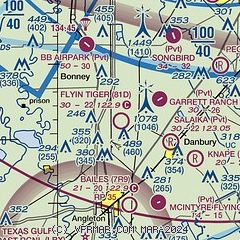
| Sectional chart |
|---|
|
| Airport distance calculator |
|---|
|
|
| Sunrise and sunset |
|---|
|
Times for 18-Jun-2026
| | Local
(UTC-5) | | Zulu
(UTC) |
|---|
| Morning civil twilight | | 05:56 | | 10:56 |
| Sunrise | | 06:23 | | 11:23 |
| Sunset | | 20:22 | | 01:22 |
| Evening civil twilight | | 20:49 | | 01:49 |
|
| Current date and time |
|---|
| Zulu (UTC) | 18-Jun-2026 15:04:23 |
|---|
| Local (UTC-5) | 18-Jun-2026 10:04:23 |
|---|
|
| METAR |
|---|
KLBX
9nm S | 181453Z AUTO 19016KT 8SM FEW017 SCT024 BKN030 31/26 A2971 RMK AO1 SLP062 T03060261 51009
|
KAXH
15nm N | 181455Z AUTO 21006KT 7SM SCT017 BKN022 30/25 A2973 RMK AO2 T03020252
|
KLVJ
17nm NE | 181453Z AUTO 19007KT 6SM HZ CLR 30/26 A2973 RMK AO2 SLP067 T03000256 53004
|
|
| TAF |
|---|
KLBX
9nm S | 181120Z 1812/1912 19008KT 4SM BR BKN012 BKN027 FM181700 18010G18KT P6SM SCT020 SCT050 FM182300 18008KT P6SM SCT020 FM190200 17009KT P6SM FEW012 BKN025
|
KLVJ
17nm NE | 181120Z 1812/1912 19004KT 3SM BR SCT009 BKN017 BKN022 FM181700 18008G17KT P6SM FEW020 SCT050 FM190100 16008KT P6SM SCT020 FM190300 15008KT P6SM BKN015 BKN025
|
|
| NOTAMs |
|---|
NOTAMs are issued by the DoD/FAA and will open in a separate window not controlled by AirNav.
|
|

