FAA INFORMATION EFFECTIVE 18 APRIL 2024
Location
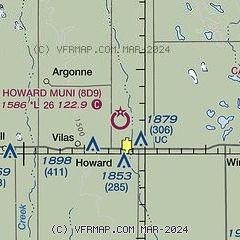
| FAA Identifier: | 8D9 |
| Lat/Long: | 44-01-59.8906N 097-32-01.2300W
44-01.998177N 097-32.020500W
44.0333029,-97.5336750
(estimated) |
| Elevation: | 1586 ft. / 483.4 m (surveyed) |
| Variation: | 07E (1985) |
| From city: | 1 mile N of HOWARD, SD |
| Time zone: | UTC -5 (UTC -6 during Standard Time) |
| Zip code: | 57349 |
Airport Operations
| Airport use: | Open to the public |
| Activation date: | 09/1947 |
| Control tower: | no |
| ARTCC: | MINNEAPOLIS CENTER |
| FSS: | HURON FLIGHT SERVICE STATION |
| NOTAMs facility: | HON (NOTAM-D service available) |
| Attendance: | UNATNDD |
| Wind indicator: | lighted |
| Segmented circle: | no |
| Lights: | ACTVT LIRL RWY 13/31 - CTAF. |
| Beacon: | white-green (lighted land airport)
Operates sunset to sunrise. |
Airport Communications
| CTAF: | 122.9 |
| WX AWOS-3 at MDS (19 nm E): | 118.35 (605-427-9380) |
Nearby radio navigation aids
| VOR radial/distance | | VOR name | | Freq | | Var |
|---|
| MHEr051/26.7 | | MITCHELL VOR/DME | | 114.15 | | 04E |
| FSDr296/39.9 | | SIOUX FALLS VORTAC | | 115.00 | | 09E |
Airport Services
| Parking: | tiedowns |
| Airframe service: | NONE |
| Powerplant service: | NONE |
| Bottled oxygen: | NONE |
| Bulk oxygen: | NONE |
Runway Information
Runway 13/31
| Dimensions: | 2656 x 150 ft. / 810 x 46 m |
| Surface: | turf, in fair condition |
| Runway edge lights: | low intensity |
| RUNWAY 13 | | RUNWAY 31 |
| Latitude: | 44-02.171167N | | 44-01.841833N |
| Longitude: | 097-32.299167W | | 097-31.900667W |
| Elevation: | 1562.0 ft. | | 1582.0 ft. |
| Traffic pattern: | left | | left |
| Touchdown point: | yes, no lights | | yes, no lights |
| Obstructions: | 14 ft. road, 300 ft. from runway, 21:1 slope to clear | | 53 ft. trees, 411 ft. from runway, 140 ft. right of centerline, 7:1 slope to clear |
Runway 18/36
| Dimensions: | 1952 x 150 ft. / 595 x 46 m |
| Surface: | turf, in fair condition |
| Runway edge markings: | RWY 18 /36 MKD WITH WHITE BLACK TIPPED MKR CONES. |
| RUNWAY 18 | | RUNWAY 36 |
| Latitude: | 44-02.146333N | | 44-01.827000N |
| Longitude: | 097-31.886667W | | 097-31.935000W |
| Elevation: | 1586.0 ft. | | 1583.0 ft. |
| Traffic pattern: | left | | left |
| Touchdown point: | yes, no lights | | yes, no lights |
| Obstructions: | 28 ft. pline, 737 ft. from runway, 26:1 slope to clear | | 4 ft. fence, 80 ft. from runway, 20:1 slope to clear |
Airport Ownership and Management from official FAA records
| Ownership: | Publicly-owned |
| Owner: | CITY OF HOWARD
PO BOX 705
HOWARD, SD 57349
Phone 605-772-4391 |
| Manager: | TIM CLARKE
PO BOX 145
HOWARD, SD 57349
Phone 605-940-9217 |
Airport Operational Statistics
| Aircraft based on the field: | | 3 | | Single engine airplanes: | | 3 |
| |  | |
| Aircraft operations: avg 60/month * | | 92% | local general aviation | | 8% | transient general aviation | | * for 12-month period ending 14 May 2020 | |
Additional Remarks
| - | RWY 13 4+ FT FENCE 45 FT R 300 FT FM THR & 125 FT R 240 FT FM THR. |
| - | WILDLIFE ON AND INVOF ARPT. |
| - | RWYS CLSD DURNG WINTER MONTHS. |
| - | FOR CD CTC MINNEAPOLIS ARTCC AT 651-463-5588. |
Instrument Procedures
There are no published instrument procedures at 8D9.
Some nearby airports with instrument procedures:
KMDS - Madison Municipal Airport (19 nm E)
KMHE - Mitchell Municipal Airport (27 nm SW)
KBKX - Brookings Regional Airport (35 nm NE)
KHON - Huron Regional Airport (37 nm NW)
4X4 - Wessington Springs Airport (43 nm W)
|
|

Road maps at:
MapQuest
Bing
Google
| Aerial photo |
|---|
WARNING: Photo may not be current or correct
 Photo by Steve Hamilton
Do you have a better or more recent aerial photo of Howard Municipal Airport that you would like to share? If so, please send us your photo.
|
| Sectional chart |
|---|
|
| Airport distance calculator |
|---|
|
|
| Sunrise and sunset |
|---|
|
Times for 19-Apr-2024
| | Local
(UTC-5) | | Zulu
(UTC) |
|---|
| Morning civil twilight | | 06:09 | | 11:09 |
| Sunrise | | 06:39 | | 11:39 |
| Sunset | | 20:19 | | 01:19 |
| Evening civil twilight | | 20:49 | | 01:49 |
|
| Current date and time |
|---|
| Zulu (UTC) | 19-Apr-2024 11:19:53 |
|---|
| Local (UTC-5) | 19-Apr-2024 06:19:53 |
|---|
|
| METAR |
|---|
KMDS
19nm E | 191055Z AUTO 27013KT 10SM M01/M07 A3016 RMK AO2 TSNO
|
KMHE
26nm SW | 191053Z AUTO 27009KT 10SM CLR 00/M07 A3023 RMK AO2 SLP247 T00001072
|
KBKX
34nm NE | 191056Z AUTO 28015KT 10SM CLR M01/M06 A3015 RMK AO2 SLP237 T10061061 FZRANO
|
KHON
37nm NW | 191055Z AUTO 28012KT 10SM CLR M01/M06 A3020 RMK AO2 SLP236 T10111061
|
|
| TAF |
|---|
KHON
37nm NW | 190520Z 1906/2006 29007KT P6SM SKC FM191300 29014G23KT P6SM SKC FM191500 30021G30KT P6SM SCT050 FM191900 31024G33KT P6SM BKN070 FM200000 32018G26KT P6SM FEW070 FM200300 31012KT P6SM SKC
|
KFSD
43nm SE | 190520Z 1906/2006 29007KT P6SM SKC FM191400 29017G25KT P6SM SKC FM191900 30023G32KT P6SM SCT060 FM200100 31015G22KT P6SM SKC
|
|
| NOTAMs |
|---|
NOTAMs are issued by the DoD/FAA and will open in a separate window not controlled by AirNav.
|
|


