FAA INFORMATION EFFECTIVE 09 JULY 2026
Location
| FAA Identifier: | ACK |
| Lat/Long: | 41-15-11.8770N 070-03-37.8410W
41-15.197950N 070-03.630683W
41.2532992,-70.0605114
(estimated) |
| Elevation: | 46.8 ft. / 14.3 m (surveyed) |
| Variation: | 14W (2030) |
| From city: | 3 miles SE of NANTUCKET, MA |
| Time zone: | UTC -4 (UTC -5 during Standard Time) |
| Zip code: | 02554 |
Airport Operations
| Airport use: | Open to the public |
| Activation date: | 04/1940 |
| Control tower: | yes |
| ARTCC: | BOSTON CENTER |
| FSS: | BRIDGEPORT FLIGHT SERVICE STATION |
| NOTAMs facility: | ACK (NOTAM-D service available) |
| Attendance: | CONTINUOUS |
| Wind indicator: | lighted |
| Segmented circle: | yes |
| Lights: | WHEN ATCT CLSD ACTVT MALSF RWY 06; SSALR RWY 24; HIRL RWY 06/24; MIRL RWY 15/33; TWY LGTS - CTAF. PAPI RWY 06, 24 & 33 OPR 24 HRS. |
| Beacon: | white-green (lighted land airport)
Operates sunset to sunrise. |
| Landing fee: | yes, FEE FOR NON-COML ACFT PRKG. |
| Fire and rescue: | ARFF index C |
| Airline operations: | ARFF INDEX C SVCS PRVD BTN 0600 AND 2200. FOR INDEX C SVCS BTN 2201 AND 0559, 2 HR PPR AT 508-325-7569 TO NANTUCKET AIRPORT OPS. PPR 2 HRS FOR UNSKED ACFT OPS WITH MORE THAN 9 PAX SEATS; CALL AMGR 508-325-5300. |
Airport Communications
| CTAF: | 118.3 |
| UNICOM: | 122.95 |
| ATIS: | 127.5 |
| WX ASOS: | PHONE 508-325-6082 |
| NANTUCKET GROUND: | 132.5 [0600-2200 MAY 15-SEP 30; 0600-2100 OCT 1-MAY 14] |
| NANTUCKET TOWER: | 118.3 [0600-2200 MAY 15-SEP 30; 0600-2100 OCT 1-MAY 14] |
| BOSTON APPROACH: | 126.1 |
| BOSTON DEPARTURE: | 126.1 |
| CLEARANCE DELIVERY: | 119.375 |
| CLAMY STAR: | 133.75 |
| DEEPO STAR: | 133.75 |
| EMERG: | 121.5 243.0 |
Nearby radio navigation aids
| VOR radial/distance | | VOR name | | Freq | | Var |
|---|
| ACKr237/2.3 | | NANTUCKET VOR/DME | | 116.20 | | 15W |
| MVYr124/26.3 | | MARTHAS VINEYARD VOR/DME | | 114.50 | | 15W |
| NDB name | | Hdg/Dist | | Freq | | Var | | ID |
|---|
| NAUSET | | 203/26.5 | | 279 | | 16W | | CQX | -.-. --.- -..- |
Airport Services
| Fuel available: | 100LL JET-A+ |
| Parking: | hangars and tiedowns |
| Airframe service: | NONE |
| Powerplant service: | NONE |
| Bottled oxygen: | NONE |
| Bulk oxygen: | NONE |
Runway Information
Runway 6/24
| Dimensions: | 6303 x 150 ft. / 1921 x 46 m |
| Surface: | asphalt/grooved, in good condition |
| Weight bearing capacity: | | Single wheel: | 75.0 | | Double wheel: | 170.0 | | Double tandem: | 280.0 |
|
| Runway edge lights: | high intensity |
| RUNWAY 6 | | RUNWAY 24 |
| Latitude: | 41-14.816498N | | 41-15.550193N |
| Longitude: | 070-04.351698W | | 070-03.378815W |
| Elevation: | 24.8 ft. | | 46.7 ft. |
| Traffic pattern: | left | | left |
| Runway heading: | 059 magnetic, 045 true | | 239 magnetic, 225 true |
| Displaced threshold: | 538 ft. | | no |
| Declared distances: | TORA:6303 TODA:6303 ASDA:6303 LDA:5765 | | TORA:6303 TODA:6303 ASDA:6303 LDA:6303 |
| Markings: | precision, in good condition | | precision, in good condition |
| Visual slope indicator: | 4-light PAPI on right (3.00 degrees glide path) | | 4-light PAPI on left (3.00 degrees glide path) |
| RVR equipment: | touchdown, rollout | | touchdown, rollout |
| Approach lights: | MALSF: 1,400 foot medium intensity approach lighting system with sequenced flashers | | SSALR: simplified short approach lighting system with runway alignment indicator lights
SSALR UNMON WHEN TWR CLSD. |
| Centerline lights: | yes | | yes |
| Touchdown point: | yes, no lights | | yes, lighted |
| Instrument approach: | ILS/DME | | ILS/DME |
Runway 15/33
| Dimensions: | 4500 x 100 ft. / 1372 x 30 m |
| Surface: | asphalt/grooved, in good condition |
| Weight bearing capacity: | | Single wheel: | 60.0 | | Double wheel: | 85.0 | | Double tandem: | 155.0 |
|
| Runway edge lights: | medium intensity |
| RUNWAY 15 | | RUNWAY 33 |
| Latitude: | 41-15.480462N | | 41-14.956240N |
| Longitude: | 070-03.649235W | | 070-02.955008W |
| Elevation: | 45.2 ft. | | 40.5 ft. |
| Traffic pattern: | left | | left |
| Runway heading: | 149 magnetic, 135 true | | 329 magnetic, 315 true |
| Declared distances: | TORA:4500 TODA:4500 ASDA:4500 LDA:4500 | | TORA:4500 TODA:4500 ASDA:4500 LDA:4500 |
| Markings: | nonprecision, in good condition | | nonprecision, in good condition |
| Visual slope indicator: | | | 4-light PAPI on left (3.00 degrees glide path) |
| Runway end identifier lights: | yes | | yes |
| Touchdown point: | yes, no lights | | yes, no lights |
| Obstructions: | 30 ft. bldg, 800 ft. from runway, 280 ft. left of centerline, 20:1 slope to clear | | none |
Airport Ownership and Management from official FAA records
| Ownership: | Publicly-owned |
| Owner: | TOWN OF NANTUCKET
SELECTMAN'S OFFICE
NANTUCKET, MA 02554
Phone 508-325-5300 |
| Manager: | WARREN SMITH
14 AIRPORT RD
NANTUCKET, MA 02554
Phone 508-325-7531 |
Additional Remarks
| A39-06/24 | PCR VALUE: 770/F/A/X/T |
| A39-15/33 | PCR VALUE: 430/F/A/X/T |
| - | BE AWARE OF HIGH-SPD MIL JET & HVY HEL TFC VCNTY AIR STATION CAPE COD. |
| - | TWY F RSTRD TO SML ACFT 12500 LBS OR LESS. |
| - | TXL F BTN TWY B & TWY H CLSD TO ACFT WITH WINGSPAN MORE THAN 79FT. |
| - | ALL ACFT, APU USE LMTD TO 15 MIN. |
| - | ARPT HAS NOISE ABATEMENT PROCS CTC NOISE OFFICER 508-325-5300. |
| - | DEER & BIRDS ON & INVOF ARPT. |
| - | FOR CD IF TWR CLSD & UNA TO CTC FSS FREQ, CTC BOSTON APCH AT 603-594-5554. |
Instrument Procedures
NOTE: All procedures below are presented as PDF files. If you need a reader for these files, you should download the free Adobe Reader.NOT FOR NAVIGATION. Please procure official charts for flight.
FAA instrument procedures published for use from 09 July 2026 at 0901Z to 06 August 2026 at 0900Z.
STARs - Standard Terminal Arrivals |
|---|
| DEEPO TWO (RNAV) **NEW** | |
download (212KB) |
IAPs - Instrument Approach Procedures |
|---|
| ILS OR LOC RWY 06 | |
download (254KB) |
| ILS OR LOC RWY 24 | |
download (230KB) |
| ILS RWY 24 (SA CAT I) | |
download (206KB) |
| ILS RWY 24 (SA CAT I) | |
download (206KB) |
| RNAV (GPS) RWY 06 | |
download (237KB) |
| RNAV (GPS) RWY 15 | |
download (239KB) |
| RNAV (GPS) RWY 24 | |
download (224KB) |
| RNAV (GPS) RWY 33 | |
download (251KB) |
| VOR RWY 24 | |
download (247KB) |
| GREAT POINT VISUAL RWY 24 | |
download (212KB) |
| TUCKERNUCK VISUAL RWY 06 | |
download (214KB) |
| NOTE: Special Alternate Minimums apply | |
download (150KB) |
| NOTE: Special Take-Off Minimums/Departure Procedures apply | |
download (515KB) |
Other nearby airports with instrument procedures:
KCQX - Chatham Municipal Airport (26 nm N)
KMVY - Martha's Vineyard Airport (26 nm W)
KHYA - Cape Cod Gateway Airport (27 nm N)
5B6 - Falmouth Airpark (29 nm NW)
KFMH - Cape Cod Coast Guard Air Station (32 nm NW)
|
|

Road maps at:
MapQuest
Bing
Google
| Aerial photo |
|---|
WARNING: Photo may not be current or correct
 Photo by Susan Soergel
Photo taken 29-Jun-2014
looking east.
Photo by Susan Soergel
Photo taken 29-Jun-2014
looking east.
Do you have a better or more recent aerial photo of Nantucket Memorial Airport that you would like to share? If so, please send us your photo.
|
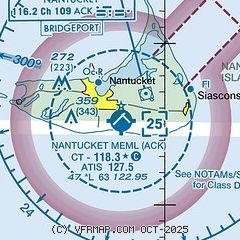
| Sectional chart |
|---|
|
 Download PDF
of official airport diagram from the FAA
| Airport distance calculator |
|---|
|
|
| Sunrise and sunset |
|---|
|
Times for 14-Jul-2026
| | Local
(UTC-4) | | Zulu
(UTC) |
|---|
| Morning civil twilight | | 04:48 | | 08:48 |
| Sunrise | | 05:20 | | 09:20 |
| Sunset | | 20:12 | | 00:12 |
| Evening civil twilight | | 20:45 | | 00:45 |
|
| Current date and time |
|---|
| Zulu (UTC) | 15-Jul-2026 02:31:11 |
|---|
| Local (UTC-4) | 14-Jul-2026 22:31:11 |
|---|
|
| METAR |
|---|
| KACK | 150153Z AUTO 24016KT 10SM CLR 21/18 A2986 RMK AO2 SLP111 T02060183 PWINO
|
|
| TAF |
|---|
| KACK | 142035Z 1421/1518 24018G26KT P6SM SKC WS020/25045KT FM150700 26018G26KT P6SM SKC FM151300 27015G22KT P6SM FEW250
|
|
| NOTAMs |
|---|
NOTAMs are issued by the DoD/FAA and will open in a separate window not controlled by AirNav.
|
|


