FAA INFORMATION EFFECTIVE 14 MAY 2026
Location
| FAA Identifier: | AMA |
| Lat/Long: | 35-13-09.7000N 101-42-21.3000W
35-13.161667N 101-42.355000W
35.2193611,-101.7059167
(estimated) |
| Elevation: | 3606.7 ft. / 1099.3 m (surveyed) |
| Variation: | 08E (2000) |
| From city: | 7 miles E of AMARILLO, TX |
| Time zone: | UTC -5 (UTC -6 during Standard Time) |
| Zip code: | 79108 |
Airport Operations
| Airport use: | Open to the public |
| Activation date: | 10/1937 |
| Control tower: | yes |
| ARTCC: | ALBUQUERQUE CENTER |
| FSS: | FORT WORTH FLIGHT SERVICE STATION |
| NOTAMs facility: | AMA (NOTAM-D service available) |
| Attendance: | CONTINUOUS |
| Pattern altitude: | 4501.7 ft. MSL
TPA: 895 FT AGL PROP ACFT, 1395 FT AGL TURBOJET ACFT, 1895 FT AGL OVERHEAD . |
| Wind indicator: | lighted |
| Segmented circle: | yes |
| Lights: | WHEN ATCT CLSD, TO INCR INTST AND ACTVT MALSR RWYS 04 & 22; REIL RWY 13; HIRL RWYS 04/22, 13/31; ALL TWYS - CTAF. |
| Beacon: | white-green (lighted land airport)
Operates sunset to sunrise. |
| Landing fee: | yes |
| Fire and rescue: | ARFF index B |
| Airline operations: | INDEX C EQUIP AVBL UPON REQ. |
| International operations: | customs landing rights airport |
Airport Communications
| CTAF: | 118.3 |
| UNICOM: | 122.95 |
| ATIS: | 118.85 350.3 |
| WX ASOS: | 118.85 (806-223-2973) |
| AMARILLO GROUND: | 121.9 348.6 [0600-0000] |
| AMARILLO TOWER: | 118.3 257.9 [0600-0000] |
| AMARILLO APPROACH: | 119.5 307.0 [0600-0000] |
| ALBUQUERQUE ARTCC APPROACH: | 121.15 307.9 [0000-0600] |
| AMARILLO DEPARTURE: | 119.5 307.0 [0600-0000] |
| ALBUQUERQUE ARTCC DEPARTURE: | 121.15 [0000-0600] |
| CLEARANCE DELIVERY: | 121.65 239.275 |
| CLASS C: | 119.5 307.0 |
| CLASS C/S: | 121.15 |
| EMERG: | 121.5 243.0 |
| IC: | 119.5 307.0 |
| WX AWOS-AV at TDW (7 nm SW): | 118.475 (806-350-7407) |
- APCH/DEP SVC PRVDD BY ALBUQUERQUE ARTCC (ZAB) ON FREQS 127.85/285.475 (AMARILLO RCAG) WHEN AMARILLO APCH CTL (AMA) CLSD.
Nearby radio navigation aids
| VOR radial/distance | | VOR name | | Freq | | Var |
|---|
| PNHr192/1.0 | | PANHANDLE VORTAC | | 116.60 | | 08E |
| NDB name | | Hdg/Dist | | Freq | | Var | | ID |
|---|
| PANDE | | 040/6.6 | | 251 | | 08E | | AM | .- -- |
Airport Services
| Fuel available: | 100LL JET-A1+ |
| Parking: | hangars and tiedowns |
| Airframe service: | MAJOR |
| Powerplant service: | MAJOR |
| Bottled oxygen: | LOW |
| Bulk oxygen: | LOW |
Runway Information
Runway 4/22
| Dimensions: | 13502 x 200 ft. / 4115 x 61 m |
| Surface: | concrete/grooved, in good condition
CENTER 130 FT GROOVED FULL LENGTH. |
| Weight bearing capacity: | | Single wheel: | 100.0 | | Double wheel: | 200.0 | | Double tandem: | 400.0 |
|
| Runway edge lights: | high intensity
RWY 04/22 NSTD HIRL DUE TO SPACING. HIRL 50 FT FM RWY EDGE, NSTD DSTC FM CNTRLN - PAVEMENT OUTSIDE RWY EDGE STRIPES MAY NOT BE FULL STRENGTH AND DEPTH PERCEPTION PROBLEMS MAY EXIST DURING PERIODS OF DARKNESS. |
| RUNWAY 4 | | RUNWAY 22 |
| Latitude: | 35-12.307055N | | 35-13.853373N |
| Longitude: | 101-43.962022W | | 101-42.012008W |
| Elevation: | 3606.4 ft. | | 3602.7 ft. |
| Traffic pattern: | left | | left |
| Runway heading: | 038 magnetic, 046 true | | 218 magnetic, 226 true |
| Declared distances: | TORA:13502 TODA:13502 ASDA:13502 LDA:13502 | | TORA:13502 TODA:13502 ASDA:13502 LDA:13502 |
| Markings: | precision, in good condition | | precision, in good condition |
| Visual slope indicator: | 4-light PAPI on left (3.00 degrees glide path) | | 4-light PAPI on left (3.00 degrees glide path) |
| RVR equipment: | touchdown
RVR AVBL 1200-0600Z CTC ATCT. | | rollout |
| Approach lights: | MALSR: 1,400 foot medium intensity approach lighting system with runway alignment indicator lights | | MALSR: 1,400 foot medium intensity approach lighting system with runway alignment indicator lights |
| Runway end identifier lights: | no | | no |
| Touchdown point: | yes, no lights | | yes, no lights |
| Instrument approach: | ILS | | LDA/DME |
Runway 13/31
| Dimensions: | 7901 x 150 ft. / 2408 x 46 m |
| Surface: | concrete/grooved, in good condition |
| Weight bearing capacity: | | Single wheel: | 100.0 | | Double wheel: | 200.0 | | Double tandem: | 400.0 |
|
| Runway edge lights: | high intensity |
| RUNWAY 13 | | RUNWAY 31 |
| Latitude: | 35-13.781673N | | 35-12.822123N |
| Longitude: | 101-41.813402W | | 101-40.740523W |
| Elevation: | 3603.2 ft. | | 3594.4 ft. |
| Traffic pattern: | left | | left |
| Runway heading: | 129 magnetic, 137 true | | 309 magnetic, 317 true |
| Declared distances: | TORA:7901 TODA:7901 ASDA:7901 LDA:7901 | | TORA:7901 TODA:7901 ASDA:7901 LDA:7901 |
| Markings: | nonprecision, in good condition | | nonprecision, in good condition |
| Visual slope indicator: | 4-light PAPI on left (3.00 degrees glide path) | | 4-light PAPI on left (3.00 degrees glide path) |
| Runway end identifier lights: | yes | | no |
| Touchdown point: | yes, no lights | | yes, no lights |
Airport Ownership and Management from official FAA records
| Ownership: | Publicly-owned |
| Owner: | CITY OF AMARILLO
PO BOX 1971
AMARILLO, TX 79105
Phone 806-378-3000 |
| Manager: | MICHAEL CONNER
10801 ARPT BLVD
AMARILLO, TX 79111
Phone 806-335-1671
MICHAEL.CONNER@AMARILLO.GOV ALT: 806-335-1671 |
Additional Remarks
| A39-13/31 | PCR VALUE: 780/R/D/W/T |
| A39-04/22 | PCR VALUE: 1820/R/D/W/T |
| - | TILTROTOR ACFT ACTIVITY INVOF ARPT. |
| - | LDG FEE. |
| - | FOR CD IF UNA TO CTC ON FSS FREQ, CTC ALBUQUERQUE ARTCC AT 505-856-4561. |
Instrument Procedures
NOTE: All procedures below are presented as PDF files. If you need a reader for these files, you should download the free Adobe Reader.NOT FOR NAVIGATION. Please procure official charts for flight.
FAA instrument procedures published for use from 14 May 2026 at 0901Z to 11 June 2026 at 0900Z.
IAPs - Instrument Approach Procedures |
|---|
| ILS OR LOC RWY 04 | |
download (316KB) |
| RNAV (RNP) Z RWY 04 | |
download (263KB) |
| RNAV (RNP) Z RWY 13 | |
download (231KB) |
| RNAV (RNP) Z RWY 22 | |
download (260KB) |
| RNAV (RNP) Z RWY 31 | |
download (227KB) |
| RNAV (GPS) Y RWY 04 | |
download (272KB) |
| RNAV (GPS) Y RWY 13 | |
download (224KB) |
| RNAV (GPS) Y RWY 22 | |
download (227KB) |
| RNAV (GPS) Y RWY 31 | |
download (245KB) |
| LDA RWY 22 | |
download (237KB) |
| HI-VOR OR TACAN RWY 04 | |
download (136KB) |
| HI-VOR OR TACAN RWY 13 | |
download (125KB) |
| HI-VOR OR TACAN RWY 31 | |
download (122KB) |
| VOR RWY 13 | |
download (191KB) |
| VOR RWY 22 | |
download (213KB) |
| VOR RWY 31 | |
download (202KB) |
| HI-VOR OR TACAN RWY 22 | |
download (135KB) |
| Radar Approach Procedures available | |
download (213KB) |
| NOTE: Special Alternate Minimums apply | |
download (137KB) |
| NOTE: Special Take-Off Minimums/Departure Procedures apply | |
download (195KB) |
Other nearby airports with instrument procedures:
KTDW - Tradewind Airport (7 nm SW)
T45 - Panhandle-Carson County Airport (19 nm NE)
KBGD - Hutchinson County Airport (33 nm NE)
KHRX - Hereford Municipal Airport (37 nm SW)
KDUX - Moore County Airport (41 nm N)
|
|

Road maps at:
MapQuest
Bing
Google
| Aerial photo |
|---|
WARNING: Photo may not be current or correct
 Photo by Scott Friend
Photo taken 21-May-2013
from 11,500' looking north.
Photo by Scott Friend
Photo taken 21-May-2013
from 11,500' looking north.
Do you have a better or more recent aerial photo of Rick Husband Amarillo International Airport that you would like to share? If so, please send us your photo.
|
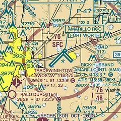
| Sectional chart |
|---|
|
CAUTION: Diagram may not be current
 Download PDF
of official airport diagram from the FAA
| Airport distance calculator |
|---|
|
|
| Sunrise and sunset |
|---|
|
Times for 25-May-2026
| | Local
(UTC-5) | | Zulu
(UTC) |
|---|
| Morning civil twilight | | 06:08 | | 11:08 |
| Sunrise | | 06:37 | | 11:37 |
| Sunset | | 20:50 | | 01:50 |
| Evening civil twilight | | 21:19 | | 02:19 |
|
| Current date and time |
|---|
| Zulu (UTC) | 26-May-2026 01:10:46 |
|---|
| Local (UTC-5) | 25-May-2026 20:10:46 |
|---|
|
| METAR |
|---|
| KAMA | 260053Z 12015KT 10SM CLR 26/07 A2998 RMK AO2 SLP103 T02560072
|
|
| TAF |
|---|
| KAMA | 251738Z 2518/2618 16007KT P6SM SKC FM252000 14011KT P6SM FEW250 FM260700 15009KT P6SM FEW250 PROB30 2609/2615 4SM -SHRA BR OVC025 FM261500 15010KT P6SM BKN100
|
|
| NOTAMs |
|---|
NOTAMs are issued by the DoD/FAA and will open in a separate window not controlled by AirNav.
|
|


