FAA INFORMATION EFFECTIVE 18 APRIL 2024
Location
| FAA Identifier: | CLT |
| Lat/Long: | 35-12-49.5000N 080-56-56.6000W
35-12.825000N 080-56.943333W
35.2137500,-80.9490556
(estimated) |
| Elevation: | 747.9 ft. / 228.0 m (surveyed) |
| Variation: | 07W (2000) |
| From city: | 5 miles W of CHARLOTTE, NC |
| Time zone: | UTC -4 (UTC -5 during Standard Time) |
| Zip code: | 28208 |
Airport Operations
| Airport use: | Open to the public |
| Activation date: | 09/1937 |
| Control tower: | yes |
| ARTCC: | ATLANTA CENTER |
| FSS: | RALEIGH FLIGHT SERVICE STATION |
| NOTAMs facility: | CLT (NOTAM-D service available) |
| Attendance: | CONTINUOUS
J8 FUEL ALSO AVBL. |
| Wind indicator: | lighted |
| Segmented circle: | no |
| Lights: | SS-SR |
| Beacon: | white-green (lighted land airport)
Operates sunset to sunrise. |
| Fire and rescue: | ARFF index E |
| International operations: | customs landing rights airport |
Airport Communications
| UNICOM: | 122.95 |
| WX ASOS: | PHONE 704-790-5484 |
| CHARLOTTE GROUND: | 121.8 ;WEST 121.9 ;EAST 348.6 |
| CHARLOTTE TOWER: | 118.1 ;RWY 18L/36R 126.4 ;RWY 18C/36C 133.35 ;RWY 18R/36L 257.8 |
| CHARLOTTE APPROACH: | 120.05 ;120-295 8000 FT & BLW 120.5 ;246-074 ABV 8000 FT 124.0 ;075-245 ABV 8000 FT 126.15 128.325 ;001-119 8000 FT & BLW 134.75 ;296-360 8000 FT & BLW 257.2 ;180-359 307.8 ;360-179 |
| CHARLOTTE DEPARTURE: | 120.05 ;120-295 8000 FT & BLW 120.5 ;246-074 ABV 8000 FT 124.0 ;075-245 ABV 8000 FT 128.325 ;001-119 8000 FT & BLW 134.75 ;296-360 8000 FT & BLW 257.2 ;180-359 307.8 ;360-179 |
| CLEARANCE DELIVERY: | 127.15 348.6 |
| ALCP: | 292.25 |
| BANKR STAR: | 135.6 377.15 |
| BARMY DP: | 124.0 307.8 |
| BEAVY DP: | 120.5 ;RWY 36L, 36C 124.0 ;RWY 18L, 18R, 18C, 36R 257.2 ;RWY 36L, 36C 307.8 ;RWY 18R, 18L, 18C, 36R |
| BOBZY DP: | 120.5 257.2 |
| BTSEY STAR: | 125.35 |
| CHARLOTTE DP: | 120.5 ;HARAY & PITTY TRANSITIONS. RW 124.0 ;BUCKL, GANTS, LILLS & RUNIE T 124.0 ;RWY 18L, 18R, 18C, 36R 257.2 ;HARAY & PITTY TRANSITION. RWY 307.8 ;BUCKL TRANSITION, RWY 18L, 18 307.8 ;GANTS, LILLS & RUNIE TRANSITI |
| CHSLY STAR: | 126.15 282.325 |
| CLASS B: | 120.05 ;120-295 8000 FT & BLW 120.5 ;246-074 ABV 8000 FT 124.0 ;075-245 ABV 8000 FT 128.325 ;001-119 8000 FT & BLW 134.75 ;296-360 8000 FT & BLW 257.2 ;180-359 307.8 ;360-179 |
| D-ATIS: | 121.15 ;ARR 132.1 ;DEP |
| EMERG: | 121.5 243.0 |
| ESTRR DP: | 120.5 257.2 |
| FILPZ STAR: | 125.35 257.2 |
| IC: | 120.05 ;120-295 8000 FT & BLW 120.5 ;246-074 ABV 8000 FT 124.0 ;075-245 ABV 8000 FT 128.325 ;001-119 8000 FT & BLW 134.75 ;296-360 8000 FT & BLW 257.2 ;180-359 307.8 ;360-179 |
| ICONS DP: | 120.5 ;RWY 36L, 36C 124.0 ;RWY 18L, 18R, 18C, 36R 257.2 ;RWY 36L, 36C 307.8 ;RWY 18R, 18L, 18C, 36R |
| JOJJO DP: | 120.5 257.2 |
| JONZE STAR: | 135.6 377.15 |
| JOOLS STAR: | 135.6 377.15 |
| KERMIT DP: | 120.5 ;235-055 124.0 ;055-235 257.2 ;235-055 307.8 ;055-235 |
| KILNS DP: | 124.0 307.8 |
| KNIGHTS DP: | 120.05 ;DEBIE, NEANO TRANSITIONS 120.05 ;FLYYN, CEGAL TRANSITIONS, 18 120.5 ;FLYYN, CEGAL TRANSITIONS RWY 128.325 ;055-235 128.325 ;PEKNN, LILLS, HAMLN, ANDYS 257.2 ;235-055 307.8 ;055-235 |
| KRITR DP: | 120.5 257.2 |
| KWEEN DP: | 120.5 ;RWY 36L, 36C 124.0 ;RWY 18L, 18R, 18C, 36R 257.2 ;RWY 36L, 36C 307.8 ;RWY 18R, 18L, 18C, 36R |
| LIINN STAR: | 125.35 257.2 |
| LILLS DP: | 124.0 307.8 |
| MAJIC STAR: | 126.15 282.325 |
| MLLET STAR: | 126.15 282.325 |
| PARQR STAR: | 125.35 257.2 |
| RASLN STAR: | 126.15 282.325 |
| STOCR STAR: | 126.15 282.325 |
| UNARM STAR: | 135.6 377.15 |
| WEAZL DP: | 120.5 257.2 |
| WX ASOS at AKH (10 nm W): | 135.725 (704-868-9034) |
| WX ASOS at UZA (15 nm S): | 120.775 (803-981-9388) |
| WX AWOS-3 at JQF (16 nm NE): | 133.675 (704-785-2145) |
| WX AWOS-3 at IPJ (19 nm NW): | 119.675 (704-735-6954) |
| WX ASOS at EQY (20 nm SE): | 135.775 (704-283-5185) |
- CD FREQ 127.2 OTS INDEFLY AT GASTONIA MUNI (AKH), GASTONIA, NC.
Nearby radio navigation aids
| VOR radial/distance | | VOR name | | Freq | | Var |
|---|
| CLTr010/1.4 | | CHARLOTTE VOR/DME | | 115.00 | | 05W |
| NDB name | | Hdg/Dist | | Freq | | Var | | ID |
|---|
| STONIA | | 089/10.3 | | 260 | | 06W | | GHJ | --. .... .--- |
| CHESTER | | 032/28.5 | | 220 | | 06W | | DCM | -.. -.-. -- |
| FIRST RIVER | | 100/31.9 | | 417 | | 06W | | SLP | ... .-.. .--. |
Airport Services
| Fuel available: | 100LL JET-A
100LL:A++(MIL), 100 & O-156 AVBL. |
| Parking: | tiedowns |
| Airframe service: | MAJOR |
| Powerplant service: | MAJOR |
| Bottled oxygen: | NONE |
| Bulk oxygen: | HIGH/LOW
LIQUID OXYGEN ALSO AVBL. |
Runway Information
Runway 18C/36C
| Dimensions: | 10000 x 150 ft. / 3048 x 46 m |
| Surface: | concrete/grooved, in good condition |
| Weight bearing capacity: | | PCN 82 /R/B/W/T | | Single wheel: | 93.0 | | Double wheel: | 200.0 | | Double tandem: | 350.0 | | Dual double tandem: | 650.0 |
|
| Runway edge lights: | high intensity |
| RUNWAY 18C | | RUNWAY 36C |
| Latitude: | 35-13.643782N | | 35-11.999535N |
| Longitude: | 080-57.190157W | | 080-57.048695W |
| Elevation: | 742.0 ft. | | 692.2 ft. |
| Traffic pattern: | left | | left |
| Runway heading: | 183 magnetic, 176 true | | 003 magnetic, 356 true |
| Declared distances: | TORA:10000 TODA:10000 ASDA:10000 LDA:10000 | | TORA:10000 TODA:10000 ASDA:10000 LDA:10000 |
| Markings: | precision, in good condition | | precision, in good condition |
| Visual slope indicator: | 4-light PAPI on right (3.00 degrees glide path) | | 4-light PAPI on left (3.00 degrees glide path) |
| RVR equipment: | touchdown, midfield, rollout | | touchdown, midfield, rollout |
| Approach lights: | MALSR: 1,400 foot medium intensity approach lighting system with runway alignment indicator lights | | ALSF2: standard 2,400 foot high intensity approach lighting system with centerline sequenced flashers (category II or III) |
| Centerline lights: | yes | | yes |
| Touchdown point: | yes, no lights | | yes, lighted |
| Instrument approach: | ILS/DME | | ILS |
| Obstructions: | 25 ft. road, 1350 ft. from runway, 425 ft. left of centerline, 46:1 slope to clear | | none |
Runway 18R/36L
| Dimensions: | 9000 x 150 ft. / 2743 x 46 m |
| Surface: | concrete/grooved, in excellent condition |
| Weight bearing capacity: | | PCN 63 /R/B/W/T | | Single wheel: | 93.0 | | Double wheel: | 200.0 | | Double tandem: | 350.0 | | Dual double tandem: | 650.0 |
|
| Runway edge lights: | high intensity |
| RUNWAY 18R | | RUNWAY 36L |
| Latitude: | 35-13.516970N | | 35-12.037128N |
| Longitude: | 080-58.045117W | | 080-57.917785W |
| Elevation: | 744.0 ft. | | 743.9 ft. |
| Traffic pattern: | left | | left |
| Runway heading: | 183 magnetic, 176 true | | 003 magnetic, 356 true |
| Declared distances: | TORA:9000 TODA:9000 ASDA:9000 LDA:9000 | | TORA:9000 TODA:9000 ASDA:9000 LDA:9000 |
| Markings: | precision, in good condition | | precision, in good condition |
| Visual slope indicator: | 4-light PAPI on right (2.80 degrees glide path) | | 4-light PAPI on left (3.00 degrees glide path) |
| RVR equipment: | touchdown, midfield, rollout | | touchdown, midfield, rollout |
| Approach lights: | ALSF2: standard 2,400 foot high intensity approach lighting system with centerline sequenced flashers (category II or III) | | ALSF2: standard 2,400 foot high intensity approach lighting system with centerline sequenced flashers (category II or III) |
| Centerline lights: | yes | | yes |
| Touchdown point: | yes, lighted | | yes, lighted |
| Instrument approach: | ILS/DME | | ILS/DME |
Runway 18L/36R
| Dimensions: | 8677 x 150 ft. / 2645 x 46 m |
| Surface: | asphalt/concrete/grooved, in good condition |
| Weight bearing capacity: | | PCN 68 /R/B/W/T | | Single wheel: | 93.0 | | Double wheel: | 200.0 | | Double tandem: | 350.0 | | Dual double tandem: | 650.0 |
|
| Runway edge lights: | high intensity |
| Operational restrictions: | ARRESTING GEAR/SYSTEM: ENGINEERED MATERIALS ARRESTING GEAR SYSTEM (EMAS) 255 FT IN LENGTH BY 170 FT IN WIDTH AT THE DEPARTURE END OF RWY 18L. |
| RUNWAY 18L | | RUNWAY 36R |
| Latitude: | 35-13.484123N | | 35-12.057427N |
| Longitude: | 080-56.169420W | | 080-56.047033W |
| Elevation: | 746.0 ft. | | 723.4 ft. |
| Traffic pattern: | left | | left |
| Runway heading: | 183 magnetic, 176 true | | 003 magnetic, 356 true |
| Declared distances: | TORA:8676 TODA:8676 ASDA:8676 LDA:8676 | | TORA:8676 TODA:8676 ASDA:8390 LDA:8390 |
| Markings: | precision, in good condition | | precision, in good condition |
| Visual slope indicator: | 4-light PAPI on left (3.00 degrees glide path) | | 4-light PAPI on right (3.00 degrees glide path) |
| RVR equipment: | touchdown, midfield, rollout | | touchdown, midfield, rollout |
| Approach lights: | | | ALSF2: standard 2,400 foot high intensity approach lighting system with centerline sequenced flashers (category II or III) |
| Runway end identifier lights: | yes | | |
| Centerline lights: | yes | | yes |
| Touchdown point: | yes, no lights | | yes, lighted |
| Instrument approach: | ILS/DME | | ILS/DME |
| Obstructions: | 19 ft. rr, 523 ft. from runway, 17:1 slope to clear | | none |
Runway 5/23
| Dimensions: | 7502 x 150 ft. / 2287 x 46 m |
| Surface: | asphalt/concrete/grooved, in fair condition
RWY 5 FIRST 625 FEET CONCRETE GROOVED; SECOND 5377 FEET ASPHALT GROOVED; LAST 1500 FEET CONCRETE WIRE COMBED. RWY 23 FIRST 1500 FEET CONCRETE WIRE COMBED; SECOND 5377 FEET ASPHALT GROOVED; LAST 625 FEET CONCRETE GROOVED. |
| Weight bearing capacity: | | PCN 73 /R/B/W/T | | Single wheel: | 93.0 | | Double wheel: | 170.0 | | Double tandem: | 350.0 | | Dual double tandem: | 650.0 |
|
| Runway edge lights: | high intensity |
| RUNWAY 5 | | RUNWAY 23 |
| Latitude: | 35-12.537145N | | 35-13.356972N |
| Longitude: | 080-56.996742W | | 080-55.868725W |
| Elevation: | 705.9 ft. | | 746.7 ft. |
| Traffic pattern: | left | | left |
| Runway heading: | 055 magnetic, 048 true | | 235 magnetic, 228 true |
| Declared distances: | TORA:7502 TODA:7502 ASDA:7092 LDA:7092 | | TORA:7502 TODA:7502 ASDA:7502 LDA:7502 |
| Markings: | precision, in good condition | | precision, in good condition |
| Visual slope indicator: | 4-light PAPI on left (3.00 degrees glide path) | | 4-light PAPI on right (3.00 degrees glide path) |
| Approach lights: | MALSR: 1,400 foot medium intensity approach lighting system with runway alignment indicator lights | | |
| Runway end identifier lights: | | | yes |
| Centerline lights: | yes | | yes |
| Touchdown point: | yes, no lights | | yes, no lights |
| Instrument approach: | ILS | | ILS/DME |
| Obstructions: | 38 ft. trees, 1500 ft. from runway, 300 ft. right of centerline, 34:1 slope to clear | | none |
Airport Ownership and Management from official FAA records
| Ownership: | Publicly-owned |
| Owner: | CITY OF CHARLOTTE
600 EAST FOURTH ST
CHARLOTTE, NC 28202
Phone 704-336-2241 |
| Manager: | HALEY GENTRY
5601 WILKINSON BLVD.
CHARLOTTE, NC 28208
Phone 704-359-4000 |
Airport Operational Statistics
| Aircraft based on the field: | | 92 | | Single engine airplanes: | | 8 | | Multi engine airplanes: | | 6 | | Jet airplanes: | | 66 | | Helicopters: | | 4 | | Military aircraft: | | 8 |
| |  | |
| Aircraft operations: avg 1373/day * | | 82% | commercial | | 13% | air taxi | | 5% | transient general aviation | | <1% | military | | * for 12-month period ending 01 March 2022 | |
Additional Remarks
| - | RWY SFC COND INFO DURG DUTY HRS PHONE ANG OPS V583-9177/9144 OR AIRBORNE 292.2. |
| - | RWY STATUS LGTS IN OPR. |
| - | TWY C4 AND C6: WHEN TAXIING AIRCRAFT WITH COCKPIT TO MAIN GEAR DISTANCE GREATER THAN 90 FT, PILOT MUST PERFORM JUDGEMENTAL OVERSTEERING INSTEAD OF COCKPIT OVER CENTERLINE STEERING. |
| - | GROUP IV ACFT WITH A WINGSPAN GTR THAN 118 FT ARE PROHIBITED FM EXITING RWY 18L/36R AT TWY C10. |
| - | TWY C10 UNUSBL FOR TXG ONTO RWY 18L/36R. |
| - | CLT RAMP, NON-MOVMT AREA, IS CTLD RAMP; CTC RAMP CTL PRIOR TO ENTERING. |
| - | DUAL TAXI BTN DEP CALL SPOTS 11/12 AND 13N/13S RSTRD TO ONE ACFT LESS THAN 214 FT AND ONE ACFT LESS THAN 118 FT OR TWO ACFT LESS THAN 171 FT. |
| - | DUAL TAXI BTN DEP CALL SPOTS 22/23 AND 24N/24S RSTRD TO ACFT WITH WINGSPANS LESS THAN 118 FT. |
| - | TWY C10 RSTRD TO ACFT WITH WINGSPAN LESS THAN 171 FT WHEN EXITING RWY. |
| - | GROUP III ACFT WITH A WINGSPAN GTR THAN 79 FT ARE PROHIBITED FM MAKING A NBND TURN ONTO TWY C WHEN TAXIING WB ON TWY A. |
| - | TWY D, RESTRICTED TO 15 MPH OR LESS WITH WINGSPAN 171 FT AND GREATER. |
| - | GROUP III ACFT WITH A WINGSPAN GTR THAN 79 FT ARE PROHIBITED FM MAKING A SBND TURN ONTO TWY C WHEN TAXIING NWBND ON TWY R. |
| - | TWY C FROM THE APCH OF RWY 18L TO RWY 05/23, AND TWY M FROM THE APRON TO RWY 18L/36R RSTRD TO 15 MPH OR LESS WITH WINGSPAN 171 FT AND GTR. |
| - | GROUP VI ACFT WITH A WINGSPAN GTR THAN 214 FT (65M) ARE PROHIBITED ON TWY M BETWEEN THE TRML RAMP AND TWY C, AS WELL AS TWY C NORTH OF TWY M. |
| - | ALL ACFT ARE PROHIBITED FM EXITING RWY 36R SEBD AT TWY R. |
| - | TRML RAMP BLUE TXL FROM SPOT 29W TO SPOT 34S MAX WINGSPAN 82 FT. |
| - | TRML RAMP ORANGE TXL FROM SPOT 26S TO SPOT 27E MAX WINGSPAN 118 FT. |
| - | TRML RAMP YELLOW TXL FROM SPOT 29C TO SPOT 33C MAX WINGSPAN 118 FT. |
| - | TRML RAMP ORANGE TXL FROM SPOT 29E TO SPOT 34N MAX WINGSPAN 82 FT. |
| - | TRML RAMP BLUE TXL AT SPOT 28S BTN CONCOURSE D & E ALLEY MAX WINGSPAN 118 FT. |
| - | TRML RAMP BLUE TXL FROM SPOT 26N TO SPOT 27W MAX WINGSPAN 118 FT. |
| - | TRML RAMP ORANGE TXL AT SPOT 28N BETWEEN CONCOURSE D & E ALLEY MAX WINGSPAN 94 FT. |
| - | AIRPLANE DESIGN GROUP-V AND ABV ACFT ARE PROHIBITED FM DEP RWY 18L. |
| - | BE ALERT FOR FLOCKS OF MIGRATORY BIRDS ON & INVOF ARPT. |
| - | ASDE-X IN USE. OPERATE TRANSPONDERS WITH ALTITUDE REPORTING MODE AND ADS-B (IF EQUIPPED) ENABLED ON ALL AIRPORT SURFACES. |
| - | MILITARY: ANG: CTC COMD POST 30 MIN PRIOR LDG. AMOPS/COMD POST - 292.25 (CALL NEWSREEL). |
| - | SUCCESSIVE OR SIMULTANEOUS DEPARTURES FROM RWY 18L AND RWY 18C ARE APPROVED WITH COURSE DIVERGENCE BEGINNING NO FURTHER THAN 4 MILES FROM END OF RWY. |
Instrument Procedures
NOTE: All procedures below are presented as PDF files. If you need a reader for these files, you should download the free Adobe Reader.NOT FOR NAVIGATION. Please procure official charts for flight.
FAA instrument procedures published for use from 18 April 2024 at 0901Z to 16 May 2024 at 0900Z.
STARs - Standard Terminal Arrivals |
|---|
| BANKR FOUR (RNAV) | |
2 pages:
[1] [2] (371KB) |
| BTSEY TWO **CHANGED** | |
download (165KB) |
| CHSLY FIVE (RNAV) | |
2 pages:
[1] [2] (480KB) |
| CHSLY FIVE (RNAV), CONT.2 | |
download (184KB) |
| FILPZ THREE (RNAV) | |
2 pages:
[1] [2] (413KB) |
| JONZE FOUR (RNAV) | |
2 pages:
[1] [2] (343KB) |
| JOOLS ONE (RNAV) | |
download (274KB) |
| LIINN THREE | |
2 pages:
[1] [2] (313KB) |
| MAJIC FOUR | |
download (263KB) |
| MLLET TWO (RNAV) | |
download (294KB) |
| PARQR THREE (RNAV) | |
2 pages:
[1] [2] (410KB) |
| RASLN THREE | |
download (198KB) |
| STOCR THREE (RNAV) | |
2 pages:
[1] [2] (443KB) |
| STOCR THREE (RNAV), CONT.2 | |
download (256KB) |
IAPs - Instrument Approach Procedures |
|---|
| ILS OR LOC RWY 18C | |
download (452KB) |
| ILS OR LOC RWY 18L | |
download (407KB) |
| ILS OR LOC RWY 18R | |
download (483KB) |
| ILS OR LOC RWY 36C | |
download (398KB) |
| ILS OR LOC RWY 36L | |
download (384KB) |
| ILS OR LOC RWY 36R | |
download (391KB) |
| ILS RWY 18R (SA CAT I) | |
download (413KB) |
| ILS RWY 36L (SA CAT I) | |
download (369KB) |
| ILS RWY 36R (SA CAT I) | |
download (373KB) |
| ILS RWY 18R (CAT II - III) | |
download (407KB) |
| ILS RWY 36C (CAT II - III) | |
download (388KB) |
| ILS RWY 36L (CAT II - III) | |
download (367KB) |
| ILS RWY 36R (CAT II - III) | |
download (373KB) |
| RNAV (RNP) Z RWY 18C | |
download (325KB) |
| RNAV (RNP) Z RWY 36C | |
download (334KB) |
| RNAV (GPS) Y RWY 18C | |
download (413KB) |
| RNAV (GPS) Y RWY 18L | |
download (366KB) |
| RNAV (GPS) Y RWY 18R | |
download (387KB) |
| RNAV (GPS) Y RWY 36C | |
download (348KB) |
| RNAV (GPS) Y RWY 36L | |
download (366KB) |
| RNAV (GPS) Y RWY 36R | |
download (356KB) |
| NOTE: Special Alternate Minimums apply | |
download (166KB) |
Departure Procedures |
|---|
| BARMY FIVE (RNAV) **NEW** | |
2 pages:
[1] [2] (389KB) |
| BEAVY SIX (RNAV) **NEW** | |
2 pages:
[1] [2] (385KB) |
| BOBZY FIVE (RNAV) **NEW** | |
2 pages:
[1] [2] (394KB) |
| CHARLOTTE THREE | |
2 pages:
[1] [2] (482KB) |
| ESTRR FIVE (RNAV) **NEW** | |
2 pages:
[1] [2] (362KB) |
| ICONS FIVE (RNAV) **NEW** | |
2 pages:
[1] [2] (376KB) |
| JOJJO FIVE (RNAV) **NEW** | |
2 pages:
[1] [2] (412KB) |
| KERMIT FOUR **NEW** | |
2 pages:
[1] [2] (468KB) |
| KILNS FIVE (RNAV) **NEW** | |
2 pages:
[1] [2] (365KB) |
| KNIGHTS THREE **CHANGED** | |
2 pages:
[1] [2] (456KB) |
| KRITR SIX (RNAV) **NEW** | |
2 pages:
[1] [2] (366KB) |
| KWEEN FIVE (RNAV) **NEW** | |
2 pages:
[1] [2] (369KB) |
| LILLS THREE (RNAV) **NEW** | |
download (279KB) |
| WEAZL FIVE (RNAV) **NEW** | |
2 pages:
[1] [2] (340KB) |
| NOTE: Special Take-Off Minimums/Departure Procedures apply | |
download (384KB) |
Other nearby airports with instrument procedures:
KAKH - Gastonia Municipal Airport (10 nm W)
KUZA - Rock Hill (York County) Airport-Bryant Field (15 nm S)
KJQF - Concord-Padgett Regional Airport (16 nm NE)
KIPJ - Lincolnton-Lincoln County Regional Airport (19 nm NW)
KEQY - Charlotte-Monroe Executive Airport (20 nm SE)
|
|

Road maps at:
MapQuest
Bing
Google
| Aerial photo |
|---|
WARNING: Photo may not be current or correct
 Photo by Kelvin Draughon
Photo taken 25-Dec-2016
looking northeast.
Photo by Kelvin Draughon
Photo taken 25-Dec-2016
looking northeast.
Do you have a better or more recent aerial photo of Charlotte/Douglas International Airport that you would like to share? If so, please send us your photo.
|
| Sectional chart |
|---|
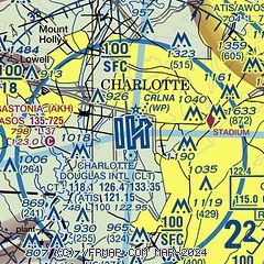
|
CAUTION: Diagram may not be current
 Download PDF
of official airport diagram from the FAA
| Airport distance calculator |
|---|
|
|
| Sunrise and sunset |
|---|
|
Times for 19-Apr-2024
| | Local
(UTC-4) | | Zulu
(UTC) |
|---|
| Morning civil twilight | | 06:20 | | 10:20 |
| Sunrise | | 06:46 | | 10:46 |
| Sunset | | 19:59 | | 23:59 |
| Evening civil twilight | | 20:26 | | 00:26 |
|
| Current date and time |
|---|
| Zulu (UTC) | 20-Apr-2024 00:17:35 |
|---|
| Local (UTC-4) | 19-Apr-2024 20:17:35 |
|---|
|
| METAR |
|---|
| KCLT | 192352Z 09006KT 10SM CLR 23/17 A2995 RMK AO2 RAE36 SLP149 P0008 60019 T02330172 10306 20217 50006
|
KAKH
10nm W | 192354Z AUTO 01003KT 10SM FEW110 21/18 A2996 RMK AO2 RAE10 SLP140 P0002 60006 T02110183 10300 20211 52008
|
KUZA
15nm S | 192354Z AUTO 00000KT 10SM CLR 23/18 A2995 RMK AO2 SLP134 60000 T02280178 10294 20228 51006
|
KJQF
15nm NE | 192250Z 00000KT 10SM CLR 28/12 A2996
|
KIPJ
19nm NW | 192345Z AUTO 18004KT 10SM CLR 25/16 A2996 RMK AO2 T02490157
|
|
| TAF |
|---|
| KCLT | 192159Z 1922/2024 VRB05KT P6SM SCT060 SCT160 SCT250 TEMPO 1922/2002 6SM TSRA BR OVC050CB FM200300 34003KT P6SM SCT110 BKN250 FM201400 36007KT P6SM BKN250 FM201900 33008KT P6SM SCT070 BKN250
|
|
| NOTAMs |
|---|
NOTAMs are issued by the DoD/FAA and will open in a separate window not controlled by AirNav.
|
|


