FAA INFORMATION EFFECTIVE 02 OCTOBER 2025
Location
| FAA Identifier: | D02 |
| Lat/Long: | 43-17-32.4000N 092-47-44.2000W
43-17.540000N 092-47.736667W
43.2923333,-92.7956111
(estimated) |
| Elevation: | 1168 ft. / 356.0 m (surveyed) |
| Variation: | 03E (1985) |
| From city: | 1 mile NE of OSAGE, IA |
| Time zone: | UTC -5 (UTC -6 during Standard Time) |
| Zip code: | 50461 |
Airport Operations
| Airport use: | Open to the public |
| Activation date: | 09/1957 |
| Control tower: | no |
| ARTCC: | MINNEAPOLIS CENTER |
| FSS: | FORT DODGE FLIGHT SERVICE STATION |
| NOTAMs facility: | FOD (NOTAM-D service available) |
| Attendance: | UNATNDD |
| Wind indicator: | yes |
| Segmented circle: | no |
| Lights: | SS-SR |
Airport Communications
| CTAF/UNICOM: | 122.8 |
| WX AWOS-3 at CCY (15 nm SE): | 125.525 (641-228-7069) |
- UNICOM LCTD OSAGE POLICE STN, 24 HR OPN, PHONE 641-732-3777.
Nearby radio navigation aids
| VOR radial/distance | | VOR name | | Freq | | Var |
|---|
| MCWr057/26.2 | | MASON CITY VOR/DME | | 114.90 | | 06E |
| RSTr191/30.7 | | ROCHESTER VOR/DME | | 112.00 | | 05E |
| AELr132/34.2 | | ALBERT LEA VOR/DME | | 109.80 | | 01E |
Airport Services
| Parking: | tiedowns |
| Airframe service: | NONE |
| Powerplant service: | NONE |
Runway Information
Runway 17/35
| Dimensions: | 3400 x 50 ft. / 1036 x 15 m |
| Surface: | asphalt, in fair condition
CTN, RWY IS SUBJECT TO FROST HEAVES |
| Runway edge lights: | medium intensity |
| RUNWAY 17 | | RUNWAY 35 |
| Latitude: | 43-17.819617N | | 43-17.259812N |
| Longitude: | 092-47.733522W | | 092-47.739243W |
| Traffic pattern: | left | | left |
| Runway heading: | 177 magnetic, 180 true | | 357 magnetic, 000 true |
| Markings: | basic, in fair condition | | basic, in fair condition |
| Obstructions: | 21 ft. road, 600 ft. from runway, 19:1 slope to clear | | 40 ft. pline, 930 ft. from runway, 18:1 slope to clear |
Airport Ownership and Management from official FAA records
| Ownership: | Publicly-owned |
| Owner: | CITY OF OSAGE
806 MAIN STREET, P.O. BOX 29
OSAGE, IA 50461
Phone 641-732-3709 |
| Manager: | BROCK WATERS CITY ADMINISTRATOR
806 MAIN, P.O. BOX 29
OSAGE, IA 50461-1439
Phone 641-832-7945 |
Additional Remarks
| - | FOR CD CTC ROCHESTER APCH AT 507-424-8111. FOR CD WHEN ROCHESTER APCH IS CLOSED, CTC MINNEAPOLIS ARTCC AT 651-463-5588. |
Instrument Procedures
There are no published instrument procedures at D02.
Some nearby airports with instrument procedures:
KCCY - Northeast Iowa Regional Airport (15 nm SE)
KAUM - Austin Municipal Airport (23 nm N)
KMCW - Mason City Municipal Airport (25 nm W)
KCJJ - Ellen Church Field Airport (29 nm E)
KAEL - Albert Lea Municipal Airport (34 nm NW)
|
|

Road maps at:
MapQuest
Bing
Google
| Aerial photo |
|---|
WARNING: Photo may not be current or correct

Do you have a better or more recent aerial photo of Osage Municipal Airport that you would like to share? If so, please send us your photo.
|
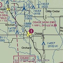
| Sectional chart |
|---|
|
| Airport distance calculator |
|---|
|
|
| Sunrise and sunset |
|---|
|
Times for 23-Oct-2025
| | Local
(UTC-5) | | Zulu
(UTC) |
|---|
| Morning civil twilight | | 07:07 | | 12:07 |
| Sunrise | | 07:36 | | 12:36 |
| Sunset | | 18:15 | | 23:15 |
| Evening civil twilight | | 18:44 | | 23:44 |
|
| Current date and time |
|---|
| Zulu (UTC) | 24-Oct-2025 04:58:17 |
|---|
| Local (UTC-5) | 23-Oct-2025 23:58:17 |
|---|
|
| METAR |
|---|
KCCY
16nm SE | 240435Z AUTO 00000KT 10SM CLR 00/00 A3021 RMK AO2
|
KAUM
23nm N | 240436Z AUTO 00000KT 10SM CLR M01/M01 A3021 RMK AO2
|
KMCW
25nm W | 240453Z AUTO 00000KT 10SM CLR 00/M01 A3021 RMK AO2 SLP233 T00001011
|
|
| TAF |
|---|
KMCW
25nm W | 231736Z 2318/2418 32012KT P6SM FEW028 FM240000 VRB04KT P6SM FEW100
|
|
| NOTAMs |
|---|
NOTAMs are issued by the DoD/FAA and will open in a separate window not controlled by AirNav.
|
|

