FAA INFORMATION EFFECTIVE 09 JULY 2026
Location
| FAA Identifier: | DRT |
| Lat/Long: | 29-22-27.1450N 100-55-37.7650W
29-22.452417N 100-55.629417W
29.3742069,-100.9271569
(estimated) |
| Elevation: | 1002.2 ft. / 305 m (estimated) |
| Variation: | 08E (2000) |
| From city: | 2 miles NW of DEL RIO, TX |
| Time zone: | UTC -5 (UTC -6 during Standard Time) |
| Zip code: | 78840 |
Airport Operations
| Airport use: | Open to the public |
| Activation date: | 11/1937 |
| Control tower: | no |
| ARTCC: | HOUSTON CENTER |
| FSS: | SAN ANGELO FLIGHT SERVICE STATION |
| NOTAMs facility: | DRT (NOTAM-D service available) |
| Attendance: | 0700-1900
AFT HRS CALL 830-768-0898. |
| Wind indicator: | lighted |
| Segmented circle: | yes |
| Lights: | ACTVT MALS RWY 13; REIL RWY 31; MIRL RWY 13/31; TWY - CTAF |
| Beacon: | white-green (lighted land airport)
Operates sunset to sunrise. |
| Landing fee: | yes, STARTS AT 6,500 LBS MTOGW |
| Fire and rescue: | ARFF index A |
| International operations: | international airport of entry |
Airport Communications
| CTAF/UNICOM: | 122.8 |
| WX ASOS: | 118.525 (830-282-0257) |
| DEL RIO APPROACH: | 119.6 [1300-0100Z++ MON-FRI; CLSD SAT; 2100-2359Z SUN EXC HOL] |
| DEL RIO DEPARTURE: | 119.6 [1300-0100Z++ MON-FRI; CLSD SAT; 2100-2359Z SUN EXC HOL] |
| CLEARANCE DELIVERY: | 120.5 |
- APCH/DEP CTL SVC PRVDD BY HOUSTON ARTCC (ZHU) ON FREQS 125.75/346.4 (ROCK SPRINGS RCAG) WHEN DEL RIO APCH CTL (DLF) CLSD.
Nearby radio navigation aids
| VOR radial/distance | | VOR name | | Freq | | Var |
|---|
| DLFr269/8.2 | | LAUGHLIN VORTAC | | 114.40 | | 07E |
| NDB name | | Hdg/Dist | | Freq | | Var | | ID |
|---|
| KOTTI | | 132/5.3 | | 335 | | 08E | | DR | -.. .-. |
| LA FONDA RANCH | | 293/18.7 | | 269 | | 09E | | BRX | -... .-. -..- |
| SPOFFORD | | 290/29.5 | | 356 | | 08E | | PFO | .--. ..-. --- |
Airport Services
| Fuel available: | 100LL JET-A+ |
| Parking: | hangars and tiedowns |
| Airframe service: | MAJOR |
| Powerplant service: | MAJOR |
Runway Information
Runway 13/31
| Dimensions: | 6300 x 100 ft. / 1920 x 30 m |
| Surface: | asphalt, in good condition |
| Weight bearing capacity: | | Single wheel: | 59.0 | | Double wheel: | 75.0 | | Double tandem: | 126.0 |
|
| Runway edge lights: | medium intensity |
| RUNWAY 13 | | RUNWAY 31 |
| Latitude: | 29-22.851833N | | 29-22.053000N |
| Longitude: | 100-56.009000W | | 100-55.249833W |
| Elevation: | 1002.2 ft. | | 995.1 ft. |
| Traffic pattern: | right | | left |
| Runway heading: | 132 magnetic, 140 true | | 312 magnetic, 320 true |
| Displaced threshold: | 300 ft. | | no |
| Declared distances: | TORA:6300 TODA:6300 ASDA:6300 LDA:6000 | | TORA:6300 TODA:6300 ASDA:5980 LDA:5980 |
| Markings: | precision, in good condition | | nonprecision, in good condition |
| Visual slope indicator: | 4-light PAPI on left (3.00 degrees glide path) | | 4-light PAPI on left (3.00 degrees glide path) |
| Approach lights: | MALS: 1,400 foot medium intensity approach lighting system | | |
| Runway end identifier lights: | | | yes |
| Touchdown point: | yes, no lights | | yes, no lights |
| Instrument approach: | ILS/DME | | |
| Obstructions: | 31 ft. tree, 922 ft. from runway, 369 ft. left of centerline, 23:1 slope to clear
50:1 SLOPE TO THE DSPLCD THR. | | 52 ft. tree, 2105 ft. from runway, 460 ft. left of centerline, 36:1 slope to clear |
Helipad H1
| Dimensions: | 46 x 46 ft. / 14 x 14 m |
| Surface: | concrete, in good condition |
| Latitude: | 29-22.119833N | | |
| Longitude: | 100-55.151667W | | |
| Elevation: | 1002.2 ft. | | |
| Traffic pattern: | left | | left |
| Markings: | none | | |
Helipad H2
| Dimensions: | 46 x 46 ft. / 14 x 14 m |
| Surface: | concrete, in good condition |
| Latitude: | 29-22.133333N | | |
| Longitude: | 100-55.133833W | | |
| Elevation: | 1002.2 ft. | | |
| Traffic pattern: | left | | left |
| Markings: | none | | |
Airport Ownership and Management from official FAA records
| Ownership: | Publicly-owned |
| Owner: | DEL RIO/VAL VERDE CO
109 W BROADWAY STREET
DEL RIO, TX 78840
Phone (830) 774-8610 |
| Manager: | JUAN ONOFRE
1104 WEST 10TH STREET
DEL RIO, TX 78840
Phone (830) 734-4857 |
Additional Remarks
| A39-13/31 | PCR VALUE: 230/F/D/X/T |
| - | HELIPAD H1 & H2 LCTD SOUTH END OF MAIN PRKG RAMP. |
| - | FOR CD CTC LAUGHLIN APCH AT 830-298-5192, WHEN APCH CLSD CTC HOUSTON ARTCC AT 281-230-5622. |
| - | THE NATIONAL WEATHER SERVICE RELEASES WEATHER BALLOONS FROM THE DEL RIO AIRPORT TWICE DAILY (1200 AND 0000 ZULU). |
| - | ARFF INDEX B AVAILABLE UPON REQUEST |
Instrument Procedures
NOTE: All procedures below are presented as PDF files. If you need a reader for these files, you should download the free Adobe Reader.NOT FOR NAVIGATION. Please procure official charts for flight.
FAA instrument procedures published for use from 09 July 2026 at 0901Z to 06 August 2026 at 0900Z.
IAPs - Instrument Approach Procedures |
|---|
| ILS OR LOC RWY 13 | |
download (270KB) |
| RNAV (GPS) RWY 13 | |
download (313KB) |
| VOR-A | |
download (211KB) |
| NOTE: Special Alternate Minimums apply | |
download (116KB) |
| NOTE: Special Take-Off Minimums/Departure Procedures apply | |
download (105KB) |
Other nearby airports with instrument procedures:
KDLF - Laughlin AFB Airport (8 nm E)
5T9 - Maverick County Memorial International Airport (38 nm SE)
KECU - Edwards County Airport (52 nm NE)
KUVA - Garner Field Airport (63 nm E)
KSOA - Sonora Municipal Airport (74 nm N)
|
|

Road maps at:
MapQuest
Bing
Google
| Aerial photo |
|---|
WARNING: Photo may not be current or correct
 Photo courtesy of GRW, Inc.
Photo taken 08-Oct-2010
looking northeast.
Photo courtesy of GRW, Inc.
Photo taken 08-Oct-2010
looking northeast.
Do you have a better or more recent aerial photo of Del Rio International Airport that you would like to share? If so, please send us your photo.
|
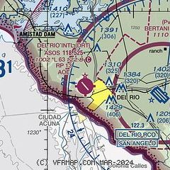
| Sectional chart |
|---|
|
| Airport distance calculator |
|---|
|
|
| Sunrise and sunset |
|---|
|
Times for 23-Jul-2026
| | Local
(UTC-5) | | Zulu
(UTC) |
|---|
| Morning civil twilight | | 06:33 | | 11:33 |
| Sunrise | | 07:00 | | 12:00 |
| Sunset | | 20:41 | | 01:41 |
| Evening civil twilight | | 21:07 | | 02:07 |
|
| Current date and time |
|---|
| Zulu (UTC) | 23-Jul-2026 09:33:07 |
|---|
| Local (UTC-5) | 23-Jul-2026 04:33:07 |
|---|
|
| METAR |
|---|
| KDRT | 230853Z AUTO 29003KT 10SM CLR 26/23 A2991 RMK AO1 SLP116 T02610233 52003
|
KDLF
8nm E | 230855Z AUTO 05006KT 10SM CLR 27/23 A2988 RMK AO2 LTG DSNT N SLP102 T02660230 51003 $
|
|
| TAF |
|---|
| KDRT | 230540Z 2306/2406 05004KT P6SM SKC FM231500 VRB03KT P6SM FEW250 FM231900 07005KT P6SM FEW250
|
KDLF
8nm E | 222216Z 2222/2324 13012KT 9999 FEW220 QNH2983INS BECMG 2300/2301 VRB06KT 9999 FEW080 QNH2984INS BECMG 2315/2316 09012KT 9999 SCT050 QNH2983INS BECMG 2319/2320 08012KT 9999 SCT060 BKN100 QNH2978INS TX39/2222Z TN25/2311Z LAST NO AMDS AFT 2222 NEXT 2310
|
|
| NOTAMs |
|---|
NOTAMs are issued by the DoD/FAA and will open in a separate window not controlled by AirNav.
|
|


