FAA INFORMATION EFFECTIVE 14 MAY 2026
Location
| FAA Identifier: | E06 |
| Lat/Long: | 32-57-14.2000N 103-24-31.6000W
32-57.236667N 103-24.526667W
32.9539444,-103.4087778
(estimated) |
| Elevation: | 3979.2 ft. / 1212.9 m (surveyed) |
| Variation: | 07E (2015) |
| From city: | 3 miles W of LOVINGTON, NM |
| Time zone: | UTC -6 (UTC -7 during Standard Time) |
| Zip code: | 88260 |
Airport Operations
| Airport use: | Open to the public |
| Activation date: | 03/1957 |
| Control tower: | no |
| ARTCC: | FORT WORTH CENTER |
| FSS: | ALBUQUERQUE FLIGHT SERVICE STATION |
| NOTAMs facility: | ABQ (NOTAM-D service available) |
| Attendance: | UNATNDD |
| Wind indicator: | lighted |
| Segmented circle: | yes |
| Lights: | DUSK-DAWN: MIRL RWY 03/21 & 12/30 PRESET LOW INTST; INCR INTST - CTAF. ACTVT PAPI RWY 03, 12, 21 & 30; MIRL RWY 03/21 & 12/30 - CTAF. |
| Beacon: | white-green (lighted land airport)
Operates sunset to sunrise. |
Airport Communications
| CTAF/UNICOM: | 122.8 |
| WX AWOS-3 at HOB (19 nm SE): | PHONE 575-393-8418 |
- APCH/DEP CTL SVC PRVDD BY FORT WORTH ARTCC (ZFW) ON FREQS 133.1/298.95 (HOBBS RCAG).
Nearby radio navigation aids
| VOR radial/distance | | VOR name | | Freq | | Var |
|---|
| HOBr329/20.2 | | HOBBS VORTAC | | 111.00 | | 11E |
Airport Services
Runway Information
Runway 3/21
| Dimensions: | 6001 x 75 ft. / 1829 x 23 m |
| Surface: | asphalt, in good condition |
| Weight bearing capacity: | | PCN 5 /F/B/Y/T | | Single wheel: | 12.0 |
|
| Runway edge lights: | medium intensity |
| RUNWAY 3 | | RUNWAY 21 |
| Latitude: | 32-56.923010N | | 32-57.622977N |
| Longitude: | 103-24.862730W | | 103-24.033232W |
| Elevation: | 3976.2 ft. | | 3966.5 ft. |
| Traffic pattern: | left | | left |
| Runway heading: | 038 magnetic, 045 true | | 218 magnetic, 225 true |
| Markings: | nonprecision, in good condition | | nonprecision, in good condition |
| Visual slope indicator: | 2-light PAPI on left (3.00 degrees glide path)
UNUSBL BYD 9 DEGS RIGHT & LEFT OF CNTRLN. | | 2-light PAPI on left (3.00 degrees glide path)
UNUSBL BYD 8 DEG RIGHT OF CNTRLN. |
| Touchdown point: | yes, no lights | | yes, no lights |
Runway 12/30
| Dimensions: | 4409 x 60 ft. / 1344 x 18 m |
| Surface: | asphalt, in good condition |
| Weight bearing capacity: | | PCN 3 /F/D/Y/T | | Single wheel: | 12.0 |
|
| Runway edge lights: | medium intensity |
| RUNWAY 12 | | RUNWAY 30 |
| Latitude: | 32-57.457797N | | 32-56.917177N |
| Longitude: | 103-24.920450W | | 103-24.344027W |
| Elevation: | 3979.2 ft. | | 3969.5 ft. |
| Traffic pattern: | left | | left |
| Runway heading: | 131 magnetic, 138 true | | 311 magnetic, 318 true |
| Markings: | basic, in good condition | | basic, in good condition |
| Visual slope indicator: | 2-light PAPI on left (3.00 degrees glide path) | | 2-light PAPI on left (3.00 degrees glide path)
UNUSBL BYD 8 DEG RIGHT OF CNTRLN. |
| Touchdown point: | yes, no lights | | yes, no lights |
Airport Ownership and Management from official FAA records
| Ownership: | Publicly-owned |
| Owner: | LEA COUNTY
PO BOX 1106
HOBBS, NM 88241-1106
Phone 575-391-2934 |
| Manager: | COREY NEEDHAM
PO BOX 1106
HOBBS, NM 88241-1106
Phone 575-391-2934 |
Additional Remarks
| A30A-03 | +3 FT PIPES 700 FT FM THR 60 FT R OF CNTRLN. |
| - | OIL DRILLING ACT ON & INVOF ARPT. |
| - | EMERG - 575-396-3611. |
| - | GATE CODE - 1228# |
| - | FOR CD CTC FORT WORTH ARTCC AT 817-858-7584. |
Instrument Procedures
NOTE: All procedures below are presented as PDF files. If you need a reader for these files, you should download the free Adobe Reader.NOT FOR NAVIGATION. Please procure official charts for flight.
FAA instrument procedures published for use from 14 May 2026 at 0901Z to 11 June 2026 at 0900Z.
IAPs - Instrument Approach Procedures |
|---|
| RNAV (GPS) RWY 03 | |
download (222KB) |
| RNAV (GPS) RWY 21 | |
download (222KB) |
| NOTE: Special Take-Off Minimums/Departure Procedures apply | |
download (299KB) |
Other nearby airports with instrument procedures:
KHOB - Lea County Regional Airport (19 nm SE)
F98 - Yoakum County Airport (33 nm NE)
KGNC - Gaines County Airport (42 nm SE)
KATS - Artesia Municipal Airport (54 nm W)
KCNM - Cavern City Air Terminal (57 nm SW)
|
|

Road maps at:
MapQuest
Bing
Google
| Aerial photo |
|---|
WARNING: Photo may not be current or correct

Do you have a better or more recent aerial photo of Lea County/Zip Franklin Memorial Airport that you would like to share? If so, please send us your photo.
|
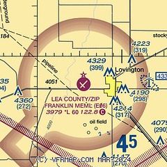
| Sectional chart |
|---|
|
 Download PDF
of official airport diagram from the FAA
| Airport distance calculator |
|---|
|
|
| Sunrise and sunset |
|---|
|
Times for 31-May-2026
| | Local
(UTC-6) | | Zulu
(UTC) |
|---|
| Morning civil twilight | | 05:19 | | 11:19 |
| Sunrise | | 05:47 | | 11:47 |
| Sunset | | 19:55 | | 01:55 |
| Evening civil twilight | | 20:24 | | 02:24 |
|
| Current date and time |
|---|
| Zulu (UTC) | 31-May-2026 15:26:46 |
|---|
| Local (UTC-6) | 31-May-2026 09:26:46 |
|---|
|
| METAR |
|---|
KHOB
20nm SE | 311350Z 18005KT 10SM CLR 22/19 A2998
|
|
| TAF |
|---|
KHOB
20nm SE | 311120Z 3112/0112 21007KT P6SM SKC FM312000 17015G22KT P6SM SCT080 BKN250 PROB30 3120/0102 VRB20G35KT -TSRA BKN080CB FM010400 17010KT P6SM OVC250
|
|
| NOTAMs |
|---|
NOTAMs are issued by the DoD/FAA and will open in a separate window not controlled by AirNav.
|
|


