FAA INFORMATION EFFECTIVE 11 JUNE 2026
Location
| FAA Identifier: | E55 |
| Lat/Long: | 38-48-06.1470N 123-31-49.9880W
38-48.102450N 123-31.833133W
38.8017075,-123.5305522
(estimated) |
| Elevation: | 933.6 ft. / 285 m (estimated) |
| Variation: | 13E (2025) |
| From city: | 3 miles N of GUALALA, CA |
| Time zone: | UTC -7 (UTC -8 during Standard Time) |
| Zip code: | 95445 |
Airport Operations
| Airport use: | Open to the public |
| Activation date: | 10/1964 |
| Control tower: | no |
| ARTCC: | OAKLAND CENTER |
| FSS: | OAKLAND FLIGHT SERVICE STATION |
| NOTAMs facility: | OAK (NOTAM-D service available) |
| Attendance: | UNATNDD |
| Wind indicator: | yes |
| Segmented circle: | yes |
Airport Communications
Nearby radio navigation aids
| VOR radial/distance | | VOR name | | Freq | | Var |
|---|
| ENIr202/19.3 | | MENDOCINO VORTAC | | 112.30 | | 16E |
Airport Services
| Parking: | tiedowns |
| Airframe service: | NONE |
| Powerplant service: | NONE |
| Bottled oxygen: | NONE |
| Bulk oxygen: | NONE |
Runway Information
Runway 13/31
| Dimensions: | 2504 x 50 ft. / 763 x 15 m |
| Surface: | asphalt, in excellent condition |
| Weight bearing capacity: | |
| RUNWAY 13 | | RUNWAY 31 |
| Latitude: | 38-48.270637N | | 38-47.934247N |
| Longitude: | 123-31.985622W | | 123-31.680660W |
| Elevation: | 929.7 ft. | | 897.4 ft. |
| Traffic pattern: | left | | right |
| Runway heading: | 132 magnetic, 145 true | | 312 magnetic, 325 true |
| Displaced threshold: | 402 ft. | | 305 ft. |
| Markings: | NSTD, in good condition | | NSTD, in good condition |
| Touchdown point: | yes, no lights | | yes, no lights |
| Obstructions: | 85 ft. trees, 1500 ft. from runway, 75 ft. right of centerline, 15:1 slope to clear
RWY 13 APCH RATIO 22:1 TO DSPLCD THLD. | | 40 ft. trees, 1000 ft. from runway, 140 ft. left of centerline, 20:1 slope to clear
RY 31 APCH RATIO 32:1 TO DSPLCD THLD. |
Airport Ownership and Management from official FAA records
| Ownership: | Privately-owned |
| Owner: | JOHN H. BOWER
BOX 1000
GUALALA, CA 95445
Phone 707-884-3579
EMAIL: JHBOWER@HOTMAIL.COM |
| Manager: | JULIE BOWER
BOX 1000
GUALALA, CA 95445
Phone 925-337-4145
EMAIL: JULIEBOWER001@GMAIL.COM |
Additional Remarks
| - | CALMWIND RWY 31. |
| - | RY 13/31 CLSD TO JETS AND ULTRALIGHTS. |
| - | RY 13/31 CLSD TO ACFT OVER 8,000 LBS ALLOWABLE TAKE-OFF GROSS WEIGHT. |
| - | RY 13/31 CLSD TO TOUCH AND GO LANDINGS. |
| - | RY SAFETY AREAS HAVE PROTRUDING OR DEPRESSED DRAINAGE AREAS. SAFETY AREA SOUTH END HAS 100+ FOOT DROPOFF. |
| - | FULL STOP LANDINGS ONLY RY 13/31. INTXN TKOFS PROHIBITED. BACK TAXI REQD RY 13. FULL LENGTH TKOF ONLY RY 13/31. |
| - | ACFT NOT VISABLE FM OPPOSITE ENDS OF RY DUE TO DOWNWARD SLOPING TERRAIN FM RY MID-POINT SOUTH TO RY APCH END OF RY 31( APPROX 15 FT DROP). |
| - | DEER FREQUENTLY ON RY. |
| - | FOR CD CTC OAKLAND ARTCC AT 510-745-3380. |
| - | CAUTION WINDSHEAR: DOWNDRAFTS ON SHORT FINAL TO RWY 31 DURG MOD TO STRONG WIND CONDS FROM THE NORTH. |
| - | EXTREME TURB IN WINDY CONDS. |
| - | RWY 13/31/ CLSD AT NIGHT. NO RWY LGTS. |
Instrument Procedures
There are no published instrument procedures at E55.
Some nearby airports with instrument procedures:
KUKI - Ukiah Municipal Airport (25 nm NE)
O60 - Cloverdale Municipal Airport (25 nm E)
KLLR - Little River Airport (30 nm N)
KHES - Healdsburg Municipal Airport (31 nm E)
1O2 - Lampson Field Airport (32 nm E)
|
|

Road maps at:
MapQuest
Bing
Google
| Aerial photo |
|---|
WARNING: Photo may not be current or correct
 Photo courtesy of Kenneth and Gabrielle Adelman
Photo taken 08-Oct-2007
Photo courtesy of Kenneth and Gabrielle Adelman
Photo taken 08-Oct-2007
Do you have a better or more recent aerial photo of Ocean Ridge Airport that you would like to share? If so, please send us your photo.
|
| Sectional chart |
|---|
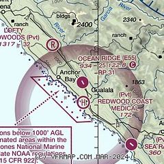
|
| Airport distance calculator |
|---|
|
|
| Sunrise and sunset |
|---|
|
Times for 28-Jun-2026
| | Local
(UTC-7) | | Zulu
(UTC) |
|---|
| Morning civil twilight | | 05:21 | | 12:21 |
| Sunrise | | 05:52 | | 12:52 |
| Sunset | | 20:42 | | 03:42 |
| Evening civil twilight | | 21:14 | | 04:14 |
|
| Current date and time |
|---|
| Zulu (UTC) | 28-Jun-2026 20:46:36 |
|---|
| Local (UTC-7) | 28-Jun-2026 13:46:36 |
|---|
|
| METAR |
|---|
KUKI
24nm NE | 281956Z AUTO 10SM CLR 26/06 A2995 RMK AO2 SLP135 T02560061
|
KLLR
30nm N | SuperAWOS
282035Z AUTO 31016G23KT 10SM CLR 19/08 A3000 RMK A01
|
KSTS
38nm SE | 707-573-8393
281953Z 13004KT 10SM CLR 27/04 A2993 RMK AO2 SLP128 T02670044
|
|
| TAF |
|---|
KUKI
24nm NE | 281740Z 2818/2918 VRB03KT P6SM SKC FM282100 32012KT P6SM SKC FM282300 31011G19KT P6SM SKC FM290200 01009KT P6SM SKC FM290600 VRB03KT P6SM SKC
|
|
| NOTAMs |
|---|
NOTAMs are issued by the DoD/FAA and will open in a separate window not controlled by AirNav.
|
|

