FAA INFORMATION EFFECTIVE 18 APRIL 2024
Location
| FAA Identifier: | EVB |
| Lat/Long: | 29-03-20.5000N 080-56-56.1000W
29-03.341667N 080-56.935000W
29.0556944,-80.9489167
(estimated) |
| Elevation: | 10.8 ft. / 3.3 m (surveyed) |
| Variation: | 04W (1990) |
| From city: | 3 miles NW of NEW SMYRNA BEACH, FL |
| Time zone: | UTC -4 (UTC -5 during Standard Time) |
| Zip code: | 32168 |
Airport Operations
| Airport use: | Open to the public |
| Activation date: | 04/1940 |
| Control tower: | yes |
| ARTCC: | JACKSONVILLE CENTER |
| FSS: | SAINT PETERSBURG FLIGHT SERVICE STATION |
| NOTAMs facility: | EVB (NOTAM-D service available) |
| Attendance: | 0700-2200
FOR ATTENDANT AFT 2200, CALL 386-410-2680. |
| Pattern altitude: | 798.8 ft. MSL
TPA FOR LGT ACFT 788 FT AGL, HVY ACFT 1188 FT AGL. |
| Wind indicator: | lighted |
| Segmented circle: | yes |
| Lights: | ACTVT MIRL RWY 11/29 & 07/25 AFTER 2300 - CTAF. |
| Beacon: | white-green (lighted land airport)
Operates sunset to sunrise. |
| Taxiway lights: | SHORT TWY FM MID RWY 15-33 TO TIE DOWN AREA ONLY TWY LGTD. |
Airport Communications
| CTAF: | 119.675 |
| UNICOM: | 122.95 |
| ATIS: | 124.625 |
| WX AWOS-3: | 124.625 (386-409-4705) |
| NEW SMYRNA BEACH GROUND: | 121.325 [0700-2200] |
| NEW SMYRNA BEACH TOWER: | 119.675 [0700-2200] |
| DAYTONA APPROACH: | 125.35 |
| DAYTONA DEPARTURE: | 125.35 |
| TTHOR STAR: | 118.85 |
| WX ASOS at DAB (9 nm NW): | PHONE 386-257-6444 |
| WX AWOS-3 at OMN (17 nm NW): | 118.475 (386-615-7084) |
| WX AWOS-3 at DED (18 nm W): | 119.575 (386-740-5811) |
Nearby radio navigation aids
| VOR radial/distance | | VOR name | | Freq | | Var |
|---|
| OMNr150/17.2 | | ORMOND BEACH VORTAC | | 112.60 | | 00E |
| ORLr033/36.9 | | ORLANDO VORTAC | | 112.20 | | 00E |
Airport Services
| Fuel available: | 100LL JET-A
A:INCLS ANTI-ICING ADDITIVE. |
| Parking: | hangars and tiedowns |
| Airframe service: | MAJOR |
| Powerplant service: | MAJOR |
| Bottled oxygen: | NONE |
| Bulk oxygen: | NONE |
Runway Information
Runway 7/25
| Dimensions: | 5000 x 75 ft. / 1524 x 23 m |
| Surface: | asphalt, in good condition |
| Weight bearing capacity: | | PCN 25 /F/A/Y/T | | Single wheel: | 55.0 |
|
| Runway edge lights: | medium intensity |
| RUNWAY 7 | | RUNWAY 25 |
| Latitude: | 29-03.292642N | | 29-03.684992N |
| Longitude: | 080-57.479898W | | 080-56.653878W |
| Elevation: | 7.5 ft. | | 9.8 ft. |
| Traffic pattern: | left | | left |
| Runway heading: | 066 magnetic, 062 true | | 246 magnetic, 242 true |
| Displaced threshold: | 335 ft. | | 300 ft. |
| Declared distances: | TORA:5000 TODA:5000 ASDA:4853 LDA:4518 | | TORA:5000 TODA:5000 ASDA:4763 LDA:4463 |
| Markings: | nonprecision, in fair condition | | nonprecision, in fair condition |
| Visual slope indicator: | 4-light PAPI on left (3.00 degrees glide path) | | 4-light PAPI on left (3.00 degrees glide path) |
| Runway end identifier lights: | yes | | yes |
| Touchdown point: | yes, no lights | | yes, no lights |
| Obstructions: | 6 ft. fence, 56 ft. from runway, 250 ft. right of centerline
RWY 07 15 FT ROAD 83 FT FM AER, 250 FT R. | | 6 ft. fence, 161 ft. from runway, 250 ft. right of centerline
RWY 25 15 FT ROAD 200 FT FM RWY END 250 FT RIGHT OF CNTRLN. |
Runway 11/29
| Dimensions: | 4319 x 75 ft. / 1316 x 23 m |
| Surface: | asphalt, in good condition |
| Weight bearing capacity: | | PCN 29 /F/A/Y/T | | Single wheel: | 55.0 |
|
| Runway edge lights: | medium intensity |
| RUNWAY 11 | | RUNWAY 29 |
| Latitude: | 29-03.354288N | | 29-03.150488N |
| Longitude: | 080-57.224362W | | 080-56.447112W |
| Elevation: | 7.8 ft. | | 10.4 ft. |
| Traffic pattern: | left | | left |
| Runway heading: | 111 magnetic, 107 true | | 291 magnetic, 287 true |
| Markings: | nonprecision, in fair condition | | nonprecision, in fair condition |
| Visual slope indicator: | 4-light PAPI on left (3.50 degrees glide path) | | 4-light PAPI on left (3.00 degrees glide path) |
| Touchdown point: | yes, no lights | | yes, no lights |
| Obstructions: | 78 ft. trees, 1780 ft. from runway, 200 ft. right of centerline, 20:1 slope to clear | | 15 ft. road, 537 ft. from runway, 250 ft. right of centerline, 21:1 slope to clear |
Runway 2/20
| Dimensions: | 4000 x 100 ft. / 1219 x 30 m |
| Surface: | asphalt, in poor condition
RWY 02/20 LONGL & TRANSVERSE CRACKING THRUT. |
| Weight bearing capacity: | | PCN 5 /F/B/Z/T | | Single wheel: | 55.0 |
|
| RUNWAY 2 | | RUNWAY 20 |
| Latitude: | 29-02.938165N | | 29-03.570608N |
| Longitude: | 080-56.983802W | | 080-56.768940W |
| Elevation: | 8.1 ft. | | 8.8 ft. |
| Traffic pattern: | left | | left |
| Runway heading: | 021 magnetic, 017 true | | 201 magnetic, 197 true |
| Displaced threshold: | 785 ft. | | no |
| Declared distances: | TORA:4000 TODA:4000 ASDA:4000 LDA:3215 | | TORA:4000 TODA:4000 ASDA:3952 LDA:3952 |
| Markings: | basic, in good condition | | basic, in good condition |
| Touchdown point: | yes, no lights | | yes, no lights |
| Obstructions: | 16 ft. road, 295 ft. from runway, 250 ft. left of centerline, 5:1 slope to clear
RWY 02 APCH RATIO 34:1 TO DSPLCD THR. | | 55 ft. trees, 1390 ft. from runway, 250 ft. right of centerline, 21:1 slope to clear |
Airport Ownership and Management from official FAA records
| Ownership: | Publicly-owned |
| Owner: | CITY OF NEW SMYRNA BEACH
210 SAMS AVE
NEW SMYRNA BEACH, FL 32168
Phone (386) 410-2610 |
| Manager: | ARVIN WEESE
NEW SMYRNA BEACH MUNI AIRPORT, 602 SKYLINE DRIVE
NEW SMYRNA BEACH, FL 32168
Phone (386) 410-2680 |
Airport Operational Statistics
| Aircraft based on the field: | | 114 | | Single engine airplanes: | | 86 | | Multi engine airplanes: | | 25 | | Jet airplanes: | | 2 | | Helicopters: | | 1 |
| |  | |
| Aircraft operations: avg 359/day * | | 65% | local general aviation | | 35% | transient general aviation | | <1% | air taxi | | <1% | military | | <1% | commercial | | * for 12-month period ending 14 August 2018 | |
Additional Remarks
| - | FOR CD OR TO CNL IFR WHEN ATCT IS CLSD CTC DAB APCH AT 386-226-3939. |
| - | UNLGTD OBSTRUCTIONS ROAD & FENCE 200 FT BFR AER 25, 250 FT RIGHT OF CENTERLINE. |
| - | UNLGTD OBSTNS ROAD & FENCE 83 FT BFR AER 07, 250 FT RIGHT OF CNTRLN. |
| - | RWY 02/20 AND TWY CRACKING WITH GRASS. |
| - | VOLUNTARY NOISE ABATEMENT IN EFCT, CTC ARPT MGR FOR DETAILS AT 386-410-2680. |
| - | BIRDS ON & INVOF ARPT. |
| - | ARPT CLSD FOR ULTRALIGHTS, EXC PPR 386-410-2680. |
Instrument Procedures
NOTE: All procedures below are presented as PDF files. If you need a reader for these files, you should download the free Adobe Reader.NOT FOR NAVIGATION. Please procure official charts for flight.
FAA instrument procedures published for use from 18 April 2024 at 0901Z to 16 May 2024 at 0900Z.
STARs - Standard Terminal Arrivals |
|---|
| TTHOR THREE (RNAV) | |
2 pages:
[1] [2] (332KB) |
IAPs - Instrument Approach Procedures |
|---|
| RNAV (GPS) RWY 02 **CHANGED** | |
download (299KB) |
| RNAV (GPS) RWY 07 **CHANGED** | |
download (310KB) |
| RNAV (GPS) RWY 25 **CHANGED** | |
download (314KB) |
| RNAV (GPS) RWY 29 **CHANGED** | |
download (308KB) |
| NOTE: Special Alternate Minimums apply | |
download |
| NOTE: Special Take-Off Minimums/Departure Procedures apply | |
download (309KB) |
Other nearby airports with instrument procedures:
X50 - Massey Ranch Airpark (5 nm S)
7FL6 - Spruce Creek Airport (5 nm W)
KDAB - Daytona Beach International Airport (9 nm NW)
KOMN - Ormond Beach Municipal Airport (17 nm NW)
KDED - DeLand Municipal Airport-Sidney H Taylor Field (18 nm W)
|
|

Road maps at:
MapQuest
Bing
Google
| Aerial photo |
|---|
WARNING: Photo may not be current or correct
 Photo courtesy of Russell Aerial Photography Inc
Photo taken 27-Jan-2018
looking east-northeast.
Do you have a better or more recent aerial photo of New Smyrna Beach Municipal Airport that you would like to share? If so, please send us your photo.
|
| Sectional chart |
|---|
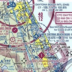
|
CAUTION: Diagram may not be current

| Airport distance calculator |
|---|
|
|
| Sunrise and sunset |
|---|
|
Times for 19-Apr-2024
| | Local
(UTC-4) | | Zulu
(UTC) |
|---|
| Morning civil twilight | | 06:29 | | 10:29 |
| Sunrise | | 06:54 | | 10:54 |
| Sunset | | 19:52 | | 23:52 |
| Evening civil twilight | | 20:16 | | 00:16 |
|
| Current date and time |
|---|
| Zulu (UTC) | 19-Apr-2024 21:20:43 |
|---|
| Local (UTC-4) | 19-Apr-2024 17:20:43 |
|---|
|
| METAR |
|---|
| KEVB | 192047Z 09008KT 10SM FEW045 28/21 A3000
|
KDAB
10nm NW | 192053Z 09007KT 10SM FEW050 28/21 A3000 RMK AO2 SLP158 T02780206 56014
|
KOMN
17nm NW | 192050Z 09008KT 7SM CLR 27/22 A3000
|
KDED
18nm W | 192055Z AUTO 26008KT 10SM BKN065 32/16 A2999 RMK AO2 T03230156
|
|
| TAF |
|---|
KDAB
10nm NW | 191737Z 1918/2018 08008KT P6SM FEW050 FM200000 VRB03KT P6SM FEW050 FM201500 28006KT P6SM SKC
|
|
| NOTAMs |
|---|
NOTAMs are issued by the DoD/FAA and will open in a separate window not controlled by AirNav.
|
|


