FAA INFORMATION EFFECTIVE 16 APRIL 2026
Location
| FAA Identifier: | F49 |
| Lat/Long: | 33-29-06.8378N 101-39-42.0400W
33-29.113963N 101-39.700667W
33.4852327,-101.6616778
(estimated) |
| Elevation: | 3126.5 ft. / 953.0 m (surveyed) |
| Variation: | 06E (2020) |
| From city: | 2 miles N of SLATON, TX |
| Time zone: | UTC -5 (UTC -6 during Standard Time) |
| Zip code: | 79364 |
Airport Operations
| Airport use: | Open to the public |
| Activation date: | 05/1968 |
| Control tower: | no |
| ARTCC: | FORT WORTH CENTER |
| FSS: | FORT WORTH FLIGHT SERVICE STATION |
| NOTAMs facility: | FTW (NOTAM-D service available) |
| Attendance: | MON-FRI 0800-1700 |
| Wind indicator: | lighted |
| Segmented circle: | yes |
| Lights: | MIRL RWY 18/36 NONSTD PCL: 3-X ON, 5-X OFF - CTAF. |
| Beacon: | white-green (lighted land airport)
Operates sunset to sunrise. |
Airport Communications
| CTAF/UNICOM: | 123.0 |
| LUBBOCK APPROACH: | 119.2 |
| LUBBOCK DEPARTURE: | 119.2 |
| WX ASOS at LBB (13 nm NW): | PHONE 806-766-6432 |
Nearby radio navigation aids
| VOR radial/distance | | VOR name | | Freq | | Var |
|---|
| LBBr125/18.2 | | LUBBOCK VORTAC | | 109.20 | | 11E |
| PVWr159/36.6 | | PLAINVIEW VOR/DME | | 112.90 | | 11E |
Airport Services
| Fuel available: | 100LL JET-A |
| Parking: | hangars and tiedowns |
| Airframe service: | MINOR |
| Powerplant service: | MINOR |
Runway Information
Runway 18/36
| Dimensions: | 4244 x 75 ft. / 1294 x 23 m |
| Surface: | asphalt, in good condition |
| Weight bearing capacity: | |
| Runway edge lights: | medium intensity |
| RUNWAY 18 | | RUNWAY 36 |
| Latitude: | 33-29.401033N | | 33-28.708537N |
| Longitude: | 101-39.599092W | | 101-39.718753W |
| Elevation: | 3122.8 ft. | | 3112.6 ft. |
| Traffic pattern: | left | | left |
| Runway heading: | 182 magnetic, 188 true | | 002 magnetic, 008 true |
| Markings: | nonprecision, in good condition | | nonprecision, in good condition |
| Visual slope indicator: | 2-light PAPI on left (3.00 degrees glide path)
PAPI OTS INDEFLY. | | 2-light PAPI on left (3.00 degrees glide path)
PAPI OTS INDEFLY. |
| Touchdown point: | yes, no lights | | yes, no lights |
| Obstructions: | 23 ft. pole, 762 ft. from runway, 258 ft. right of centerline, 24:1 slope to clear | | none |
Runway 8/26
| Dimensions: | 1720 x 65 ft. / 524 x 20 m |
| Surface: | turf, in poor condition
RWY SFC ROUGH. |
| RUNWAY 8 | | RUNWAY 26 |
| Latitude: | 33-29.249833N | | 33-29.271067N |
| Longitude: | 101-39.972683W | | 101-39.635250W |
| Elevation: | 3126.5 ft. | | 3122.5 ft. |
| Traffic pattern: | left | | left |
| Runway heading: | 080 magnetic, 086 true | | 260 magnetic, 266 true |
| Markings: | none | | none |
| Touchdown point: | yes, no lights | | yes, no lights |
| Obstructions: | 6 ft. brush, 57 ft. from runway, 9:1 slope to clear | | none |
Airport Ownership and Management from official FAA records
| Ownership: | Publicly-owned |
| Owner: | CITY OF SLATON
130 S 9TH ST
SLATON, TX 79364
Phone 806-828-2000 |
| Manager: | ROBERT NEAL
12106 FM 400
SLATON, TX 79364
Phone 806-828-5892
F.B.O. LESEE. |
Additional Remarks
| - | ACFT NOT VSB FM OPPSITE ENDS OF RWY. |
| - | AEROBATIC ACTVT SR-SS, MOD USE ON WKENDS. |
| - | FOR CD CTC FORT WORTH ARTCC AT 817-858-7584. |
| - | 3457 FT MSL, 348 FT AGL TWR, 1.75 NM SW OF ARPT. |
| - | RWY 08/26 CLSD PERMLY. |
Instrument Procedures
NOTE: All procedures below are presented as PDF files. If you need a reader for these files, you should download the free Adobe Reader.NOT FOR NAVIGATION. Please procure official charts for flight.
FAA instrument procedures published for use from 16 April 2026 at 0901Z to 14 May 2026 at 0900Z.
IAPs - Instrument Approach Procedures |
|---|
| RNAV (GPS) RWY 18 | |
download (190KB) |
| RNAV (GPS) RWY 36 | |
download (195KB) |
| NOTE: Special Take-Off Minimums/Departure Procedures apply | |
download (300KB) |
Other nearby airports with instrument procedures:
F82 - Lubbock Executive Airpark (8 nm W)
KLBB - Lubbock Preston Smith International Airport (13 nm NW)
8F3 - Crosbyton Municipal Airport (23 nm E)
KBFE - Terry County Airport (33 nm SW)
41F - Floydada Municipal Airport (35 nm NE)
|
|

Road maps at:
MapQuest
Bing
Google
| Aerial photo |
|---|
WARNING: Photo may not be current or correct
 Photo taken 26-Jul-2009
Do you have a better or more recent aerial photo of City of Slaton/Larry T Neal Memorial Airport that you would like to share? If so, please send us your photo.
|
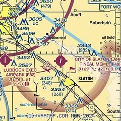
| Sectional chart |
|---|
|
| Airport distance calculator |
|---|
|
|
| Sunrise and sunset |
|---|
|
Times for 30-Apr-2026
| | Local
(UTC-5) | | Zulu
(UTC) |
|---|
| Morning civil twilight | | 06:34 | | 11:34 |
| Sunrise | | 07:00 | | 12:00 |
| Sunset | | 20:28 | | 01:28 |
| Evening civil twilight | | 20:54 | | 01:54 |
|
| Current date and time |
|---|
| Zulu (UTC) | 30-Apr-2026 08:39:04 |
|---|
| Local (UTC-5) | 30-Apr-2026 03:39:04 |
|---|
|
| METAR |
|---|
KLBB
13nm NW | 300753Z 11010KT 10SM BKN250 11/06 A3001 RMK AO2 SLP133 T01110056
|
|
| TAF |
|---|
KLBB
13nm NW | 300533Z 3006/0106 10011KT P6SM BKN200 FM301300 08011KT P6SM BKN015 OVC035 FM301800 09010KT P6SM OVC200 FM010300 07009KT 6SM BR OVC009
|
|
| NOTAMs |
|---|
NOTAMs are issued by the DoD/FAA and will open in a separate window not controlled by AirNav.
|
|


