FAA INFORMATION EFFECTIVE 14 MAY 2026
Location
| FAA Identifier: | FA54 |
| Lat/Long: | 26-51-13.4700N 082-15-09.3700W
26-51.224500N 082-15.156167W
26.8537417,-82.2526028
(estimated) |
| Elevation: | 7 ft. / 2 m (estimated) |
| Variation: | 05W (2015) |
| From city: | 2 miles NE of PLACIDA, FL |
| Time zone: | UTC -4 (UTC -5 during Standard Time) |
| Zip code: | 33981 |
Airport Operations
| Airport use: | Private use. Permission required prior to landing |
| Control tower: | no |
| ARTCC: | MIAMI CENTER |
| FSS: | SAINT PETERSBURG FLIGHT SERVICE STATION |
| NOTAMs facility: | FDC (NOTAM-D service not available) |
| Attendance: | 0800-1700 |
| Wind indicator: | yes |
| Segmented circle: | no |
| Lights: | ACTVT REIL RWY 5 & 23; PAPI RWY 5 & 23; MIRL RWY 05/23 - CTAF. |
| Beacon: | white-green (lighted land airport)
ACTVT BCN - 130.65. |
| Landing fee: | yes |
Airport Communications
| CTAF: | 130.65 |
| FORT MYERS APPROACH: | 127.05 |
| FORT MYERS DEPARTURE: | 127.05 |
| CLEARANCE DELIVERY: | 121.625 |
| LUBBR STAR: | 119.65 |
| WX ASOS at PGD (15 nm E): | 135.675 (941-639-0076) |
| WX AWOS-3 at VNC (16 nm NW): | 119.275 (941-486-2718) |
Nearby radio navigation aids
| VOR radial/distance | | VOR name | | Freq | | Var |
|---|
| RSWr309/32.1 | | LEE COUNTY VORTAC | | 114.15 | | 02W |
| SRQr158/37.1 | | SARASOTA VOR/DME | | 117.00 | | 05W |
Airport Services
| Fuel available: | 100LL JET-A+ |
| Parking: | hangars and tiedowns |
| Bottled oxygen: | NONE |
| Bulk oxygen: | NONE |
Runway Information
Runway 5/23
| Dimensions: | 6000 x 100 ft. / 1829 x 30 m |
| Surface: | asphalt, in excellent condition |
| Weight bearing capacity: | | Single wheel: | 30.0 | | Double wheel: | 100.0 |
|
| Runway edge lights: | medium intensity |
| RUNWAY 5 | | RUNWAY 23 |
| Latitude: | 26-50.899167N | | 26-51.549833N |
| Longitude: | 082-15.572333W | | 082-14.740000W |
| Elevation: | 7.0 ft. | | 7.0 ft. |
| Traffic pattern: | right | | left |
| Runway heading: | 054 magnetic, 049 true | | 234 magnetic, 229 true |
| Displaced threshold: | 250 ft. | | 446 ft. |
| Markings: | nonprecision, in good condition | | nonprecision, in good condition |
| Visual slope indicator: | 4-light PAPI on left (3.00 degrees glide path) | | 4-light PAPI on left (3.00 degrees glide path) |
| Runway end identifier lights: | yes | | yes |
| Touchdown point: | yes, no lights | | yes, no lights |
| Obstructions: | 61 ft. trees, 1242 ft. from runway, 60 ft. right of centerline, 20:1 slope to clear | | 32 ft. pline, 600 ft. from runway, 150 ft. right of centerline, 20:1 slope to clear |
Airport Ownership and Management from official FAA records
| Ownership: | Privately-owned |
| Owner: | BK IV AS LLC D/B/A CORAL CREEK ARPT
ATTN: STEPHANIE NEWMAN, 18130 EDISON AVENUE
CHESTERFIELD, MO 63005
Phone 636-532-9205 |
| Manager: | MOE HUNN
11901 GASPARILLA ROAD
PLACIDA, FL 33946
Phone (941) 214-3012
ADDL CTC STEPHANIE NEWMAN 636-532-9205; SNEWMAN@SPIRITFLIGHTEAST.COM |
Additional Remarks
| - | ARPT ADVISORY - 130.65 |
| - | 54A AWOS-3PT IS ASSOCIATED WITH CORAL CREEK AIRPORT FA54. |
| - | FOR CD CTC FORT MYERS APCH AT 239-416-1026, WHEN APCH CLSD CTC MIAMI ARTCC AT 305-716-1731. |
Instrument Procedures
NOTE: All procedures below are presented as PDF files. If you need a reader for these files, you should download the free Adobe Reader.NOT FOR NAVIGATION. Please procure official charts for flight.
FAA instrument procedures published for use from 14 May 2026 at 0901Z to 11 June 2026 at 0900Z.
STARs - Standard Terminal Arrivals |
|---|
| LUBBR FOUR (RNAV) | |
2 pages:
[1] [2] (420KB) |
| PIKKR SEVEN (RNAV) | |
download (204KB) |
Other nearby airports with instrument procedures:
KPGD - Punta Gorda Airport (15 nm E)
KVNC - Venice Municipal Airport (16 nm NW)
KFMY - Page Field Airport (26 nm SE)
X06 - Arcadia Municipal Airport (30 nm NE)
KRSW - Southwest Florida International Airport (33 nm SE)
|
|

Road maps at:
MapQuest
Bing
Google
| Aerial photo |
|---|
WARNING: Photo may not be current or correct

Do you have a better or more recent aerial photo of Coral Creek Airport that you would like to share? If so, please send us your photo.
|
| Sectional chart |
|---|
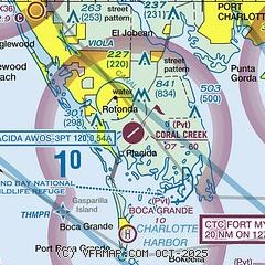
|
| Airport distance calculator |
|---|
|
|
| Sunrise and sunset |
|---|
|
Times for 03-Jun-2026
| | Local
(UTC-4) | | Zulu
(UTC) |
|---|
| Morning civil twilight | | 06:10 | | 10:10 |
| Sunrise | | 06:36 | | 10:36 |
| Sunset | | 20:18 | | 00:18 |
| Evening civil twilight | | 20:44 | | 00:44 |
|
| Current date and time |
|---|
| Zulu (UTC) | 03-Jun-2026 19:43:47 |
|---|
| Local (UTC-4) | 03-Jun-2026 15:43:47 |
|---|
|
| METAR |
|---|
KPGD
14nm E | 031853Z 08011KT 10SM FEW029 BKN046 29/22 A3006 RMK AO2 SLP178 T02940217
|
KVNC
16nm NW | 031915Z AUTO 10008KT 10SM SCT028 SCT036 BKN050 OVC060 29/22 A3003 RMK AO2 T02860224 $
|
KFMY
26nm SE | 031912Z 05007KT 10SM BKN025 OVC110 28/22 A3004 RMK AO2 RAE01 P0000 T02780222
|
|
| TAF |
|---|
KPGD
14nm E | 031727Z 0318/0418 06011KT P6SM VCSH SCT020 BKN040 OVC100 TEMPO 0320/0323 VRB10G20KT 4SM TSRA BKN020CB FM040000 06012KT P6SM OVC040 FM040500 06010KT P6SM SCT040 OVC100 FM041400 08015G25KT P6SM BKN050 OVC100
|
|
| NOTAMs |
|---|
NOTAMs are issued by the DoD/FAA and will open in a separate window not controlled by AirNav.
|
|


