FAA INFORMATION EFFECTIVE 09 JULY 2026
Location
| FAA Identifier: | FWS |
| Lat/Long: | 32-33-54.4810N 097-18-30.3820W
32-33.908017N 097-18.506367W
32.5651336,-97.3084394
(estimated) |
| Elevation: | 700.4 ft. / 213.5 m (surveyed) |
| Variation: | 03E (2025) |
| From city: | 14 miles S of FORT WORTH, TX |
| Time zone: | UTC -5 (UTC -6 during Standard Time) |
| Zip code: | 76028 |
Airport Operations
| Airport use: | Open to the public |
| Activation date: | 07/1988 |
| Control tower: | yes |
| ARTCC: | FORT WORTH CENTER |
| FSS: | FORT WORTH FLIGHT SERVICE STATION |
| NOTAMs facility: | FWS (NOTAM-D service available) |
| Attendance: | 0700-2200 |
| Wind indicator: | lighted |
| Segmented circle: | yes |
| Lights: | ACTVT MALSR RWY 36L - CTAF. WHEN ATCT CLSD MIRL RWY 18R/36L PRESET ON MED INTST. |
| Beacon: | white-green (lighted land airport)
Operates sunset to sunrise. |
Airport Communications
| CTAF: | 124.625 |
| UNICOM: | 122.7 |
| ATIS: | 120.025 |
| WX AWOS-3PT: | 120.025 (817-426-4172) |
| SPINKS GROUND: | 119.475 [0700-2000] |
| SPINKS TOWER: | 124.625 [0700-2000] |
| LONE STAR APPROACH: | 135.975 |
| LONE STAR DEPARTURE: | 135.975 |
| BOTCH DP: | 135.975 |
| DALLAS AREA DP: | 135.975 |
| DODJE STAR: | 125.2 125.9 |
| GARLAND DP: | 135.975 |
| JOE POOL DP: | 135.975 |
| LIKES STAR: | 125.8 ;SOUTH 135.975 ;NORTH |
| MOTZA STAR: | 118.1 ;SOUTH 125.8 ;NORTH |
| NANDR RNAV DP: | 135.975 |
| REEKO STAR: | 125.2 |
| SASIE STAR: | 124.3 |
| SWVAY STAR: | 135.975 |
| TRUUK RNAV STAR: | 124.3 |
| WESAT STAR: | 118.1 ;SOUTH 125.8 ;NORTH |
| WX ASOS at GKY (12 nm NE): | 127.375 (817-557-0251) |
| WX AWOS-3 at CPT (14 nm SW): | 119.525 (817-641-4135) |
| WX AWOS-3P at GPM (15 nm NE): | 118.475 (972-606-1433) |
| WX ASOS at FTW (16 nm N): | PHONE 817-740-3346 |
Nearby radio navigation aids
| VOR radial/distance | | VOR name | | Freq | | Var |
|---|
| FUZr193/20.5 | | RANGER VORTAC | | 115.70 | | 06E |
| TTTr211/22.7 | | MAVERICK VOR/DME | | 113.10 | | 06E |
| CVEr220/28.2 | | COWBOY VOR/DME | | 116.20 | | 06E |
| MQPr097/36.1 | | MILLSAP VORTAC | | 117.70 | | 09E |
Airport Services
| Fuel available: | 100LL JET-A
100LL:100LL FULL AND SELF-SERVE. |
| Parking: | hangars and tiedowns |
| Airframe service: | MAJOR |
| Powerplant service: | MAJOR |
Runway Information
Runway 18R/36L
| Dimensions: | 6002 x 100 ft. / 1829 x 30 m |
| Surface: | asphalt, in good condition |
| Weight bearing capacity: | | Single wheel: | 60.0 | | Double wheel: | 70.0 | | Double tandem: | 100.0 |
|
| Runway edge lights: | medium intensity |
| RUNWAY 18R | | RUNWAY 36L |
| Latitude: | 32-34.350867N | | 32-33.361033N |
| Longitude: | 097-18.579250W | | 097-18.581467W |
| Elevation: | 700.4 ft. | | 689.1 ft. |
| Traffic pattern: | right | | left |
| Runway heading: | 177 magnetic, 180 true | | 357 magnetic, 360 true |
| Markings: | precision, in good condition | | precision, in good condition |
| Visual slope indicator: | 4-light PAPI on left (3.00 degrees glide path) | | 4-light PAPI on left (3.00 degrees glide path) |
| Approach lights: | | | MALSR: 1,400 foot medium intensity approach lighting system with runway alignment indicator lights |
| Touchdown point: | yes, no lights | | yes, no lights |
| Instrument approach: | | | ILS |
| Obstructions: | 100 ft. pline, marked, 4150 ft. from runway, 39:1 slope to clear | | 42 ft. trees, 1300 ft. from runway, 280 ft. right of centerline, 26:1 slope to clear |
Runway 18L/36R
| Dimensions: | 3660 x 60 ft. / 1116 x 18 m |
| Surface: | turf, in good condition |
| Operational restrictions: | AVBL ONLY DURG DALGT/VFR AND DRY WEATHER SFC CONDS. |
| RUNWAY 18L | | RUNWAY 36R |
| Latitude: | 32-34.295167N | | 32-33.691667N |
| Longitude: | 097-18.385000W | | 097-18.385000W |
| Elevation: | 694.2 ft. | | 695.0 ft. |
| Traffic pattern: | left | | right |
| Runway heading: | 177 magnetic, 180 true | | 357 magnetic, 000 true |
| Markings: | none, in fair condition | | none, in fair condition |
| Touchdown point: | yes, no lights | | yes, no lights |
| Obstructions: | none | | 8 ft. gnd, 320 ft. from runway, 40:1 slope to clear |
Airport Ownership and Management from official FAA records
| Ownership: | Publicly-owned |
| Owner: | CITY OF FORT WORTH
201 AMERICAN CONCOURSE, SUITE 330
FORT WORTH, TX 76106
Phone 817-392-5400 |
| Manager: | JOE HAMMOND
450 ALSBURY CT.
FORT WORTH, TX 76028
Phone 817-392-5430 |
Additional Remarks
| - | NOISE ABATEMENT PROCEDURE: AVOID NOISE SENSITIVE AREAS ALL QUADRANT OF ARPT; MAINTAIN ALTITUDES AT OR ABOVE 1000 FT AGL OVER THESE AREAS. |
| - | HEL SKIDDING OPNS PROHIBITED. |
| - | TWY A UNLIGHTED. |
| - | BIRDS & WILDLIFE INVOF ARPT. |
| - | ROTORCRAFT OPNS PROHIBITED IN SELF SVC FUEL AREAS. |
| - | FOR CD WHEN ATCT IS CLSD CTC LONE STAR APCH AT 972-615-2799. |
| - | ROTORCRAFT OPNS PROHIBITED ON TWY A BTN TWY H AND TWY A2. |
Instrument Procedures
NOTE: All procedures below are presented as PDF files. If you need a reader for these files, you should download the free Adobe Reader.NOT FOR NAVIGATION. Please procure official charts for flight.
FAA instrument procedures published for use from 09 July 2026 at 0901Z to 06 August 2026 at 0900Z.
STARs - Standard Terminal Arrivals |
|---|
| DODJE SIX **NEW** | |
2 pages:
[1] [2] (673KB) |
| MOTZA ONE **NEW** | |
2 pages:
[1] [2] (424KB) |
| REEKO THREE (RNAV) **NEW** | |
download (214KB) |
| SASIE EIGHT **NEW** | |
2 pages:
[1] [2] (437KB) |
| SWVAY FOUR (RNAV) **NEW** | |
download (239KB) |
| TRUUK THREE (RNAV) **NEW** | |
download (198KB) |
| WESAT THREE (RNAV) **NEW** | |
download (210KB) |
IAPs - Instrument Approach Procedures |
|---|
| ILS OR LOC RWY 36L **CHANGED** | |
download (225KB) |
| RNAV (GPS) RWY 18R **CHANGED** | |
download (204KB) |
| RNAV (GPS) RWY 36L **CHANGED** | |
download (204KB) |
| NOTE: Special Alternate Minimums apply | |
download (117KB) |
Departure Procedures |
|---|
| BOTCH TWO (RNAV) | |
2 pages:
[1] [2] (354KB) |
| DALLAS FOUR | |
2 pages:
[1] [2] (330KB) |
| GARLAND SIX | |
2 pages:
[1] [2] (327KB) |
| JOE POOL EIGHT | |
2 pages:
[1] [2] (446KB) |
| KINGDOM FIVE | |
2 pages:
[1] [2] (351KB) |
| KUSSO THREE (RNAV) | |
2 pages:
[1] [2] (328KB) |
| NANDR FOUR (RNAV) | |
2 pages:
[1] [2] (328KB) |
| TEXOMA FIVE | |
2 pages:
[1] [2] (436KB) |
| WORTH ONE | |
2 pages:
[1] [2] (417KB) |
| NOTE: Special Take-Off Minimums/Departure Procedures apply | |
download (301KB) |
Other nearby airports with instrument procedures:
KGKY - Arlington Municipal Airport (12 nm NE)
KNFW - Fort Worth Naval Air Station JRB (Carswell Field) Airport (14 nm NW)
KCPT - Cleburne Regional Airport (14 nm SW)
50F - Bourland Field Airport (14 nm W)
KGPM - Grand Prairie Municipal Airport (15 nm NE)
KFTW - Fort Worth Meacham International Airport (16 nm N)
|
|

Road maps at:
MapQuest
Bing
Google
| Aerial photo |
|---|
WARNING: Photo may not be current or correct
 Photo by Jeff Law
Photo taken 28-Aug-2014
looking southeast.
Photo by Jeff Law
Photo taken 28-Aug-2014
looking southeast.
Do you have a better or more recent aerial photo of Fort Worth Spinks Airport that you would like to share? If so, please send us your photo.
|
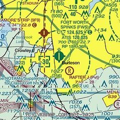
| Sectional chart |
|---|
|
CAUTION: Diagram may not be current
 Download PDF
of official airport diagram from the FAA
| Airport distance calculator |
|---|
|
|
| Sunrise and sunset |
|---|
|
Times for 20-Jul-2026
| | Local
(UTC-5) | | Zulu
(UTC) |
|---|
| Morning civil twilight | | 06:09 | | 11:09 |
| Sunrise | | 06:37 | | 11:37 |
| Sunset | | 20:35 | | 01:35 |
| Evening civil twilight | | 21:02 | | 02:02 |
|
| Current date and time |
|---|
| Zulu (UTC) | 20-Jul-2026 17:41:36 |
|---|
| Local (UTC-5) | 20-Jul-2026 12:41:36 |
|---|
|
| METAR |
|---|
| KFWS | 201650Z 19005KT 7SM CLR 34/22 A2997
|
KGKY
12nm NE | 201653Z 00000KT 10SM CLR 33/22 A2996 RMK AO2 SLP135 T03330217 $
|
KNFW
14nm NW | 201552Z 27004KT 10SM CLR 33/22 A2997 RMK AO2 SLP131 T03280217
|
KCPT
14nm SW | 201715Z AUTO VRB04KT 10SM CLR 34/20 A2993 RMK AO2 T03390196 $
|
KGPM
15nm NE | 201715Z AUTO 30003KT 10SM CLR 34/20 A2997 RMK AO2 T03390202
|
KFTW
16nm N | 201653Z 20006KT 10SM CLR 33/22 A2996 RMK AO2 SLP132 T03330217
|
|
| TAF |
|---|
KGKY
12nm NE | 201436Z 2015/2112 19007KT P6SM FEW060
|
KNFW
14nm NW | 201500Z 2015/2115 VRB06KT 9999 SCT070 QNH2983INS TX39/2022Z TN27/2112Z FN20070
|
KFTW
16nm N | 201436Z 2015/2112 19007KT P6SM FEW060
|
|
| NOTAMs |
|---|
NOTAMs are issued by the DoD/FAA and will open in a separate window not controlled by AirNav.
|
|


