FAA INFORMATION EFFECTIVE 16 MAY 2024
Location
| FAA Identifier: | GGI |
| Lat/Long: | 41-42-35.6000N 092-44-09.5000W
41-42.593333N 092-44.158333W
41.7098889,-92.7359722
(estimated) |
| Elevation: | 1008.4 ft. / 307.4 m (surveyed) |
| Variation: | 02E (2000) |
| From city: | 1 mile S of GRINNELL, IA |
| Time zone: | UTC -5 (UTC -6 during Standard Time) |
| Zip code: | 50112 |
Airport Operations
| Airport use: | Open to the public |
| Activation date: | 11/1987 |
| Control tower: | no |
| ARTCC: | CHICAGO CENTER |
| FSS: | FORT DODGE FLIGHT SERVICE STATION |
| NOTAMs facility: | GGI (NOTAM-D service available) |
| Attendance: | MON-FRI 0800-1700, ALL SAT 0800-1200 |
| Wind indicator: | lighted |
| Segmented circle: | no |
| Lights: | MIRL RWY 13/31 PRESET ON LOW INTST; TO INCR INTST & ACTVT PAPI & REIL RWYS 13 & 31- CTAF. |
| Beacon: | white-green (lighted land airport)
Operates sunset to sunrise. |
Airport Communications
| CTAF/UNICOM: | 122.8 |
| WX AWOS-3: | 120.725 (641-236-9720) |
| WX AWOS-3 at TNU (13 nm W): | 132.275 (641-791-3302) |
- APCH/DEP SVC PRVDD BY CHICAGO ARTCC ON FREQS 127.05/282.35 (DES MOINES RCAG).
Nearby radio navigation aids
| VOR radial/distance | | VOR name | | Freq | | Var |
|---|
| TNUr102/17.3 | | NEWTON VOR/DME | | 112.50 | | 03E |
| NDB name | | Hdg/Dist | | Freq | | Var | | ID |
|---|
| PELLA | | 025/20.6 | | 257 | | 02E | | PEA | .--. . .- |
Airport Services
| Fuel available: | 100LL JET-A
100LL:FOR FUEL AFT HRS CALL (641) 236-0188. |
| Parking: | hangars and tiedowns |
| Airframe service: | MAJOR |
| Powerplant service: | MAJOR |
Runway Information
Runway 13/31
| Dimensions: | 5200 x 75 ft. / 1585 x 23 m |
| Surface: | concrete/grooved, in excellent condition |
| Weight bearing capacity: | | PCN 12 /R/C/W/U | | Single wheel: | 30.0 | | Double wheel: | 30.0 |
|
| Runway edge lights: | medium intensity |
| RUNWAY 13 | | RUNWAY 31 |
| Latitude: | 41-42.874787N | | 41-42.312707N |
| Longitude: | 092-44.589812W | | 092-43.727900W |
| Elevation: | 988.8 ft. | | 1007.8 ft. |
| Traffic pattern: | left | | left |
| Runway heading: | 129 magnetic, 131 true | | 309 magnetic, 311 true |
| Displaced threshold: | 200 ft. | | 200 ft. |
| Markings: | nonprecision, in good condition | | nonprecision, in good condition |
| Visual slope indicator: | 2-light PAPI on left (3.00 degrees glide path) | | 2-light PAPI on left (3.00 degrees glide path) |
| Runway end identifier lights: | yes | | yes |
| Touchdown point: | yes, no lights | | yes, no lights |
| Obstructions: | 40 ft. tree, 1230 ft. from runway, 53 ft. left of centerline, 25:1 slope to clear
RWY 13 APCH SLP 35:1 TO DSPLCD THR. | | 52 ft. tree, 1109 ft. from runway, 84 ft. left of centerline, 17:1 slope to clear
RWY 31 APCH SLP 25:1 TO DSPLCD THR. |
Airport Ownership and Management from official FAA records
| Ownership: | Publicly-owned |
| Owner: | CITY OF GRINNELL
CITY HALL 927 4TH AVE
GRINNELL, IA 50112
Phone 641-236-2605 |
| Manager: | RON LOWRY
1607 W ST S
GRINNELL, IA 50112
Phone 641-236-0188 |
Airport Operational Statistics
| Aircraft based on the field: | | 19 | | Single engine airplanes: | | 17 | | Jet airplanes: | | 1 | | Helicopters: | | 1 |
| |  | |
| Aircraft operations: avg 101/week * | | 60% | local general aviation | | 40% | transient general aviation | | * for 12-month period ending 11 April 2022 | |
Additional Remarks
| - | RY 31 IS CALM WIND RY. |
| - | FOR CD IF UNA TO CTC ON FSS FREQ, CTC CHICAGO ARTCC AT 630-906-8921. |
Instrument Procedures
NOTE: All procedures below are presented as PDF files. If you need a reader for these files, you should download the free Adobe Reader.NOT FOR NAVIGATION. Please procure official charts for flight.
FAA instrument procedures published for use from 16 May 2024 at 0901Z to 13 June 2024 at 0900z.
IAPs - Instrument Approach Procedures |
|---|
| RNAV (GPS) RWY 13 | |
download (220KB) |
| RNAV (GPS) RWY 31 | |
download (195KB) |
| VOR/DME RWY 31 | |
download (189KB) |
| NOTE: Special Alternate Minimums apply | |
download (25KB) |
| NOTE: Special Take-Off Minimums/Departure Procedures apply | |
download (158KB) |
Other nearby airports with instrument procedures:
KTNU - Newton Municipal Airport-Earl Johnson Field (13 nm W)
KPEA - Pella Municipal Airport (21 nm SW)
KTZT - Belle Plaine Municipal Airport (23 nm NE)
KMIW - Marshalltown Municipal Airport (25 nm N)
KOXV - Knoxville Municipal Airport (30 nm SW)
|
|

Road maps at:
MapQuest
Bing
Google
| Aerial photo |
|---|
WARNING: Photo may not be current or correct

Do you have a better or more recent aerial photo of Grinnell Regional Airport that you would like to share? If so, please send us your photo.
|
| Sectional chart |
|---|
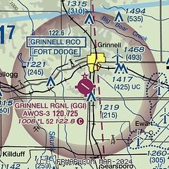
|
| Airport distance calculator |
|---|
|
|
| Sunrise and sunset |
|---|
|
Times for 17-May-2024
| | Local
(UTC-5) | | Zulu
(UTC) |
|---|
| Morning civil twilight | | 05:17 | | 10:17 |
| Sunrise | | 05:49 | | 10:49 |
| Sunset | | 20:25 | | 01:25 |
| Evening civil twilight | | 20:57 | | 01:57 |
|
| Current date and time |
|---|
| Zulu (UTC) | 17-May-2024 17:21:43 |
|---|
| Local (UTC-5) | 17-May-2024 12:21:43 |
|---|
|
| METAR |
|---|
| KGGI | 171655Z AUTO 16005KT 10SM CLR 26/13 A2979 RMK AO2 T02580125
|
KTNU
13nm W | 171655Z AUTO 23005G13KT 10SM CLR 26/10 A2977 RMK A01
|
|
| TAF |
|---|
KOTM
39nm S | 171122Z 1712/1812 18004KT P6SM SKC TEMPO 1712/1714 2SM BR FEW001 FM171700 17007KT P6SM FEW250
|
KDSM
43nm W | 171122Z 1712/1812 18006KT P6SM SCT150 FM171700 19010KT P6SM FEW250 FM180100 16007KT P6SM SKC
|
KCID
47nm E | 171120Z 1712/1812 00000KT P6SM SKC FM171600 18008KT P6SM SKC
|
|
| NOTAMs |
|---|
NOTAMs are issued by the DoD/FAA and will open in a separate window not controlled by AirNav.
|
|

