FAA INFORMATION EFFECTIVE 18 APRIL 2024
Location
| FAA Identifier: | GVE |
| Lat/Long: | 38-09-21.5860N 078-09-56.8080W
38-09.359767N 078-09.946800W
38.1559961,-78.1657800
(estimated) |
| Elevation: | 454 ft. / 138 m (estimated) |
| Variation: | 10W (2010) |
| From city: | 3 miles NE of GORDONSVILLE, VA |
| Time zone: | UTC -4 (UTC -5 during Standard Time) |
| Zip code: | 22942 |
Airport Operations
| Airport use: | Open to the public |
| Activation date: | 03/1940 |
| Control tower: | no |
| ARTCC: | WASHINGTON CENTER |
| FSS: | LEESBURG FLIGHT SERVICE STATION |
| NOTAMs facility: | DCA (NOTAM-D service available) |
| Attendance: | UNATNDD |
| Wind indicator: | lighted |
| Segmented circle: | no |
| Lights: | ACTIVATE MIRL RY 05/23 - CTAF. |
| Beacon: | white-green (lighted land airport)
Operates sunset to sunrise. |
Airport Communications
| CTAF/UNICOM: | 123.0 |
| WX AWOS-3: | 120.225 (540-832-2095) |
| POTOMAC APPROACH: | 132.85 |
| POTOMAC DEPARTURE: | 132.85 |
| WX AWOS-3 at OMH (8 nm NE): | 118.075 (540-672-0505) |
| WX AWOS-3 at LKU (13 nm SE): | 119.475 (540-967-1983) |
| WX ASOS at CHO (14 nm W): | PHONE 434-973-5024 |
- COMMUNICATIONS PRVDD BY LEESBURG RADIO ON FREQ 122.1R/115.6T (GORDONSVILLE RCO).
Nearby radio navigation aids
| VOR radial/distance | | VOR name | | Freq | | Var |
|---|
| GVEr002/8.6 | | GORDONSVILLE VORTAC | | 115.60 | | 06W |
| CSNr212/32.4 | | CASANOVA VORTAC | | 116.30 | | 06W |
| BRVr263/39.8 | | BROOKE VORTAC | | 114.50 | | 09W |
| NDB name | | Hdg/Dist | | Freq | | Var | | ID |
|---|
| NAILR | | 224/21.7 | | 351 | | 10W | | MSQ | -- ... --.- |
| SHANNON | | 269/34.4 | | 237 | | 10W | | EZF | . --.. ..-. |
| CAVERNS | | 165/35.6 | | 245 | | 09W | | LUA | .-.. ..- .- |
Airport Services
| Parking: | tiedowns |
| Airframe service: | NONE |
| Powerplant service: | NONE |
| Bottled oxygen: | NONE |
| Bulk oxygen: | NONE |
Runway Information
Runway 5/23
| Dimensions: | 2300 x 40 ft. / 701 x 12 m |
| Surface: | asphalt, in excellent condition |
| Weight bearing capacity: | |
| Runway edge lights: | medium intensity |
| RUNWAY 5 | | RUNWAY 23 |
| Latitude: | 38-09.209850N | | 38-09.508617N |
| Longitude: | 078-10.094100W | | 078-09.798933W |
| Elevation: | 453.0 ft. | | 442.0 ft. |
| Traffic pattern: | left | | left |
| Runway heading: | 048 magnetic, 038 true | | 228 magnetic, 218 true |
| Displaced threshold: | no | | 440 ft. |
| Markings: | basic, in good condition | | basic, in good condition |
| Visual slope indicator: | panels that may or may not be lighted, on right | | panels that may or may not be lighted, on right |
| Touchdown point: | yes, no lights | | yes, no lights |
| Obstructions: | 11 ft. tree, 217 ft. from runway, 46 ft. left of centerline, 1:1 slope to clear | | 77 ft. tree, 567 ft. from runway, 130 ft. right of centerline, 4:1 slope to clear
LINE OF TREES 120 FT S OF RWY CNTRLN. |
Airport Ownership and Management from official FAA records
| Ownership: | Publicly-owned |
| Owner: | TOWN OF GORDONSVILLE
P.O. BOX 276
GORDONSVILLE, VA 22942
Phone 540-832-2233 |
| Manager: | DEBORAH S. KENDALL, TOWN MGR
PO BOX 276
GORDONSVILLE, VA 22942
Phone (540) 832-2233 |
Airport Operational Statistics
| Aircraft based on the field: | | 23 | | Single engine airplanes: | | 21 | | Multi engine airplanes: | | 1 | | Helicopters: | | 1 |
| |  | |
| Aircraft operations: avg 30/day * | | 74% | local general aviation | | 22% | transient general aviation | | 3% | military | | <1% | air taxi | | * for 12-month period ending 30 June 2023 | |
Additional Remarks
| - | FOR CD CTC POTOMAC APCH AT 866-640-4124. |
Instrument Procedures
NOTE: All procedures below are presented as PDF files. If you need a reader for these files, you should download the free Adobe Reader.NOT FOR NAVIGATION. Please procure official charts for flight.
FAA instrument procedures published for use from 18 April 2024 at 0901Z to 16 May 2024 at 0900Z.
IAPs - Instrument Approach Procedures |
|---|
| RNAV (GPS)-A | |
download (178KB) |
| RNAV (GPS)-B | |
download (185KB) |
| NOTE: Special Take-Off Minimums/Departure Procedures apply | |
download (140KB) |
Other nearby airports with instrument procedures:
KOMH - Orange County Airport (8 nm NE)
KLKU - Louisa County Airport/Freeman Field (13 nm SE)
KCHO - Charlottesville-Albemarle Airport (14 nm W)
7W4 - Lake Anna Airport (23 nm SE)
KCJR - Culpeper Regional Airport (26 nm NE)
|
|

Road maps at:
MapQuest
Bing
Google
| Aerial photo |
|---|
WARNING: Photo may not be current or correct
 Photo taken 26-Oct-2008
Do you have a better or more recent aerial photo of Gordonsville Municipal Airport that you would like to share? If so, please send us your photo.
|
| Sectional chart |
|---|
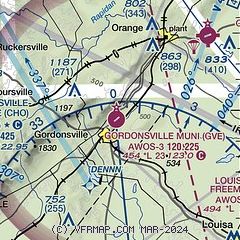
|
| Airport distance calculator |
|---|
|
|
| Sunrise and sunset |
|---|
|
Times for 19-Apr-2024
| | Local
(UTC-4) | | Zulu
(UTC) |
|---|
| Morning civil twilight | | 06:04 | | 10:04 |
| Sunrise | | 06:31 | | 10:31 |
| Sunset | | 19:52 | | 23:52 |
| Evening civil twilight | | 20:20 | | 00:20 |
|
| Current date and time |
|---|
| Zulu (UTC) | 19-Apr-2024 13:06:59 |
|---|
| Local (UTC-4) | 19-Apr-2024 09:06:59 |
|---|
|
| METAR |
|---|
| KGVE | 191255Z AUTO 00000KT 3SM OVC005 12/12 A3009 RMK AO1 T01220116
|
KOMH
8nm NE | 191255Z AUTO 12007KT 2SM BR OVC004 11/11 A3011 RMK AO2
|
KLKU
13nm SE | 191255Z AUTO 11004KT 1 3/4SM BR OVC003 11/11 A3011 RMK AO2 T01150112
|
KCHO
13nm W | 191253Z 14006KT 2SM HZ OVC004 14/12 A3008 RMK AO2 SLP180 T01440117
|
|
| TAF |
|---|
KCHO
13nm W | 191130Z 1912/2012 11003KT 6SM -DZ OVC007 FM191600 16005KT P6SM OVC015 FM192000 17005KT P6SM VCSH SCT015 BKN035 FM200400 03003KT 4SM BR SCT007 BKN015
|
|
| NOTAMs |
|---|
NOTAMs are issued by the DoD/FAA and will open in a separate window not controlled by AirNav.
|
|

