FAA INFORMATION EFFECTIVE 14 MAY 2026
Location
| FAA Identifier: | HXD |
| Lat/Long: | 32-13-28.1820N 080-41-50.6430W
32-13.469700N 080-41.844050W
32.2244950,-80.6974008
(estimated) |
| Elevation: | 19.3 ft. / 5.9 m (surveyed) |
| Variation: | 07W (2005) |
| From city: | 3 miles E of HILTON HEAD ISLAND, SC |
| Time zone: | UTC -4 (UTC -5 during Standard Time) |
| Zip code: | 29926 |
Airport Operations
| Airport use: | Open to the public |
| Control tower: | yes |
| ARTCC: | JACKSONVILLE CENTER |
| FSS: | ANDERSON FLIGHT SERVICE STATION |
| NOTAMs facility: | HXD (NOTAM-D service available) |
| Attendance: | 0600-2200 |
| Wind indicator: | lighted |
| Segmented circle: | yes |
| Lights: | ACTVT REILS RWY 03 & 21; PAPI RWY 03 & 21; MIRL RWY 03/21 - CTAF. |
| Beacon: | white-green (lighted land airport)
Operates sunset to sunrise. |
| Fire and rescue: | ARFF index B |
| Airline operations: | CLSD TO UNSKED ACR OPNS WITH MORE THAN 30 PSGR SEATS EXCP 24 HRS PPR CALL AMGR (843) 255-2950 |
Airport Communications
| CTAF: | 118.975 |
| ATIS: | 121.4 |
| WX AWOS-3PT: | 121.4 (843-342-5072) |
| HILTON HEAD GROUND: | 121.1 [0700-2100] |
| HILTON HEAD TOWER: | 118.975 [0700-2100] |
| SAVANNAH APPROACH: | 125.3 |
| SAVANNAH DEPARTURE: | 125.3 |
| CLEARANCE DELIVERY: | 121.1 123.85 ;WHEN HXD TWR CLSD |
| WX AWOS-3 at ARW (12 nm N): | 119.675 (843-524-1000) |
- APCH/DEP SVC PRVDD BY JACKSONVILLE ARTCC ON FREQS 132.925/363.2 (SAVANNAH RCAG) WHEN SAVANNAH APCH CTL CLSD.
Nearby radio navigation aids
| VOR radial/distance | | VOR name | | Freq | | Var |
|---|
| SVNr062/25.9 | | HUNTER VOR/DME | | 111.60 | | 02W |
| SAVr086/25.9 | | SAVANNAH VORTAC | | 115.95 | | 06W |
Airport Services
| Fuel available: | 100LL JET-A |
| Parking: | tiedowns |
| Airframe service: | MAJOR |
| Powerplant service: | MAJOR |
| Bottled oxygen: | NONE |
| Bulk oxygen: | NONE |
Runway Information
Runway 3/21
| Dimensions: | 5000 x 100 ft. / 1524 x 30 m |
| Surface: | asphalt/grooved, in good condition |
| Weight bearing capacity: | | Single wheel: | 55.0 | | Double wheel: | 75.0 |
|
| Runway edge lights: | medium intensity |
| RUNWAY 3 | | RUNWAY 21 |
| Latitude: | 32-13.099320N | | 32-13.840073N |
| Longitude: | 080-42.057138W | | 080-41.630937W |
| Elevation: | 18.8 ft. | | 11.1 ft. |
| Traffic pattern: | left | | left |
| Runway heading: | 033 magnetic, 026 true | | 213 magnetic, 206 true |
| Displaced threshold: | 297 ft. | | 403 ft. |
| Declared distances: | TORA:5000 TODA:5000 ASDA:5000 LDA:4703 | | TORA:5000 TODA:5000 ASDA:5000 LDA:4597 |
| Markings: | nonprecision, in good condition | | nonprecision, in good condition |
| Visual slope indicator: | 4-light PAPI on left (3.00 degrees glide path)
PAPI UNUSBL BYD 7 DEGS LEFT OF CNTRLN. | | 4-light PAPI on right (3.00 degrees glide path) |
| Runway end identifier lights: | yes | | yes |
| Touchdown point: | yes, no lights | | yes, no lights |
| Instrument approach: | | | LOC/DME |
| Obstructions: | 56 ft. tree, 1325 ft. from runway, 250 ft. right of centerline, 20:1 slope to clear | | 55 ft. tree, 1300 ft. from runway, 225 ft. right of centerline, 20:1 slope to clear
33:1 TO DSPLCD THLD ; TREES AT 1600 FT. |
Airport Ownership and Management from official FAA records
| Ownership: | Publicly-owned |
| Owner: | BEAUFORT COUNTY
120 BEACH CITY ROAD
HILTON HEAD ISLAND, SC 29926
Phone 843-255-2950 |
| Manager: | JON REMBOLD
120 BEACH CITY ROAD
HILTON HEAD ISLAND, SC 29926
Phone 843-255-2952 |
Additional Remarks
| A39-03/21 | PCR VALUE: 420/F/B/X/T |
| E60-21 | ENGINEERED MATERIALS ARRESTING SYSTEM (EMAS) 211 FT IN LENGTH BY 105 FT IN WIDTH LCTD AT THE DER 21. |
| E60-03 | ENGINEERED MATERIALS ARRESTING SYSTEM (EMAS) 207 FT IN LENGTH BY 105 FT IN WIDTH LCTD AT THE DER 03. |
| - | NOISE ABATEMENT PROCS IN EFC, CTC OPS (843) 255-2960. |
| - | BIRDS ON & INVOF ARPT. |
| - | PARASAIL OPNS WITHIN 3 NM RADIUS OF SAV 009 DEGS/15 NM, SFC TO 1500 DURG DALGT HRS. |
| - | DEER ON AND INVOF ARPT. |
Instrument Procedures
NOTE: All procedures below are presented as PDF files. If you need a reader for these files, you should download the free Adobe Reader.NOT FOR NAVIGATION. Please procure official charts for flight.
FAA instrument procedures published for use from 14 May 2026 at 0901Z to 11 June 2026 at 0900Z.
IAPs - Instrument Approach Procedures |
|---|
| RNAV (GPS) RWY 03 | |
download (239KB) |
| RNAV (GPS) RWY 21 | |
download (296KB) |
| LOC RWY 21 | |
download (287KB) |
| VOR-A | |
download (286KB) |
| BROAD CREEK VISUAL RWY 03 | |
download (171KB) |
| NOTE: Special Alternate Minimums apply | |
download (51KB) |
| NOTE: Special Take-Off Minimums/Departure Procedures apply | |
download (273KB) |
Other nearby airports with instrument procedures:
KARW - Beaufort Executive Airport (12 nm N)
KNBC - Beaufort Marine Corps Air Station (Merritt Field) Airport (15 nm N)
KSVN - Hunter Army Airfield (26 nm SW)
KSAV - Savannah/Hilton Head International Airport (26 nm W)
KRBW - Lowcountry Regional Airport (42 nm N)
|
|

Road maps at:
MapQuest
Bing
Google
| Aerial photo |
|---|
WARNING: Photo may not be current or correct
 Photo courtesy of Pilot Getaways magazine
www.pilotgetaways.com/
Do you have a better or more recent aerial photo of Hilton Head Airport that you would like to share? If so, please send us your photo.
|
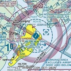
| Sectional chart |
|---|
|
| Airport distance calculator |
|---|
|
|
| Sunrise and sunset |
|---|
|
Times for 01-Jun-2026
| | Local
(UTC-4) | | Zulu
(UTC) |
|---|
| Morning civil twilight | | 05:50 | | 09:50 |
| Sunrise | | 06:18 | | 10:18 |
| Sunset | | 20:23 | | 00:23 |
| Evening civil twilight | | 20:51 | | 00:51 |
|
| Current date and time |
|---|
| Zulu (UTC) | 01-Jun-2026 18:17:27 |
|---|
| Local (UTC-4) | 01-Jun-2026 14:17:27 |
|---|
|
| METAR |
|---|
| KHXD | 011750Z 31006KT 280V350 10 SM SCT018 BKN035 27/22 A2996
|
KNBC
15nm N | 011756Z 29006KT 7SM -RA SCT019 SCT041 OVC080 27/22 A2995 RMK AO2 RAB34 SLP142 VIS NE 6 P0000 60000 T02670222 10289 20217 58007
|
|
| TAF |
|---|
KNBC
15nm N | 011500Z 0117/0215 VRB06KT 9999 BKN020 BKN040 OVC060 QNH2990INS TEMPO 0118/0122 9000 -RA BR FM012200 VRB03KT 9999 SCT010 BKN040 QNH2989INS FM020200 VRB03KT 9999 SCT040 QNH2989INS TX30/0120Z TN22/0210Z AMD 1710
|
|
| NOTAMs |
|---|
NOTAMs are issued by the DoD/FAA and will open in a separate window not controlled by AirNav.
|
|


