FAA INFORMATION EFFECTIVE 14 MAY 2026
Location
| FAA Identifier: | I35 |
| Lat/Long: | 36-51-33.5930N 083-21-30.5080W
36-51.559883N 083-21.508467W
36.8593314,-83.3584744
(estimated)
EST |
| Elevation: | 1564.1 ft. / 476.7 m (surveyed) |
| Variation: | 04W (1985) |
| From city: | 2 miles NW of HARLAN, KY |
| Time zone: | UTC -4 (UTC -5 during Standard Time) |
| Zip code: | 40806 |
Airport Operations
| Airport use: | Open to the public |
| Activation date: | 11/1961 |
| Control tower: | no |
| ARTCC: | INDIANAPOLIS CENTER |
| FSS: | LOUISVILLE FLIGHT SERVICE STATION |
| NOTAMs facility: | LOU (NOTAM-D service available) |
| Attendance: | 0900-DUSK
AFT HR - 606-273-9220. |
| Wind indicator: | lighted |
| Segmented circle: | yes |
| Lights: | SR-SS ACTVT REILS RWY 08 & 26; MIRLS RWY 08/26 - CTAF |
| Beacon: | white-green (lighted land airport)
DALGT ONLY. |
Airport Communications
| CTAF/UNICOM: | 122.8 |
| WX AWOS-3: | 118.35 (606-573-9104) |
| WX AWOS-3 at 0VG (14 nm SE): | 120.125 (276-346-3333) |
- APCH/DEP SVC PRVDD BY INDIANAPOLIS ARTCC (ZID) ON FREQS 124.625/371.925 (LONDON 2 RCAG).
Nearby radio navigation aids
| VOR radial/distance | | VOR name | | Freq | | Var |
|---|
| LOZr109/37.5 | | LONDON VOR/DME | | 116.55 | | 03W |
Airport Services
| Fuel available: | 100LL JET-A+ |
| Parking: | hangars and tiedowns |
Runway Information
Runway 8/26
| Dimensions: | 3461 x 75 ft. / 1055 x 23 m |
| Surface: | asphalt, in good condition |
| Weight bearing capacity: | |
| Runway edge lights: | medium intensity
DALGT ONLY. |
| Operational restrictions: | TREES BOTH SIDES VIOLATE 7:1 TRSN SFC. |
| RUNWAY 8 | | RUNWAY 26 |
| Latitude: | 36-51.491763N | | 36-51.627997N |
| Longitude: | 083-21.852953W | | 083-21.163897W |
| Elevation: | 1523.9 ft. | | 1564.1 ft. |
| Traffic pattern: | left | | left |
| Runway heading: | 080 magnetic, 076 true | | 260 magnetic, 256 true |
| Markings: | nonprecision, in good condition | | nonprecision, in good condition |
| Visual slope indicator: | 2-box VASI on left (5.00 degrees glide path)
DALGT ONLY; OTS. | | |
| Runway end identifier lights: | yes
DALGT ONLY. | | yes
DALGT ONLY. |
| Touchdown point: | yes, no lights | | yes, no lights |
| Obstructions: | 189 ft. trees, 2852 ft. from runway, 463 ft. left of centerline, 14:1 slope to clear | | 57 ft. trees, 382 ft. from runway, 244 ft. right of centerline, 3:1 slope to clear |
Airport Ownership and Management from official FAA records
| Ownership: | Publicly-owned |
| Owner: | HARLAN COUNTY ARPT BOARD
P.O. BOX 892
HARLAN, KY 40831
Phone (606) 573-9140 |
| Manager: | MARK MIRACLE
P.O. BOX 884, APT: 1494 HWY 1084 BAXTER, KY 40806
HARLAN, KY 40831
Phone 606-573-9140 |
Additional Remarks
| - | CTN: MTUS TRRN; PSBL TURB. |
| - | FOR CD CTC INDIANAPOLIS ARTCC AT 317-247-2411. |
| - | CREDIT CARD FUEL AVBL H24. |
Instrument Procedures
NOTE: All procedures below are presented as PDF files. If you need a reader for these files, you should download the free Adobe Reader.NOT FOR NAVIGATION. Please procure official charts for flight.
FAA instrument procedures published for use from 14 May 2026 at 0901Z to 11 June 2026 at 0900Z.
IAPs - Instrument Approach Procedures |
|---|
| RNAV (GPS)-A | |
download (179KB) |
| NOTE: Special Alternate Minimums apply | |
download (136KB) |
| NOTE: Special Take-Off Minimums/Departure Procedures apply | |
download (382KB) |
Other nearby airports with instrument procedures:
0VG - Lee County Airport (14 nm SE)
1A6 - Middlesboro/Bell County Airport (24 nm SW)
3A2 - New Tazewell Municipal Airport (29 nm S)
KCPF - Wendell H Ford Airport (32 nm N)
KRVN - Hawkins County Airport (33 nm SE)
|
|

Road maps at:
MapQuest
Bing
Google
| Aerial photo |
|---|
WARNING: Photo may not be current or correct
 Photo by Adam Miracle
Photo taken 27-Dec-2017
looking east.
Photo by Adam Miracle
Photo taken 27-Dec-2017
looking east.
Do you have a better or more recent aerial photo of Tucker-Guthrie Memorial Airport that you would like to share? If so, please send us your photo.
|
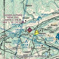
| Sectional chart |
|---|
|
| Airport distance calculator |
|---|
|
|
| Sunrise and sunset |
|---|
|
Times for 27-May-2026
| | Local
(UTC-4) | | Zulu
(UTC) |
|---|
| Morning civil twilight | | 05:49 | | 09:49 |
| Sunrise | | 06:19 | | 10:19 |
| Sunset | | 20:42 | | 00:42 |
| Evening civil twilight | | 21:12 | | 01:12 |
|
| Current date and time |
|---|
| Zulu (UTC) | 27-May-2026 15:38:40 |
|---|
| Local (UTC-4) | 27-May-2026 11:38:40 |
|---|
|
| METAR |
|---|
| KI35 | 271455Z AUTO 24004KT 10SM BKN027 OVC036 24/19 A3010 RMK AO2 T02440188
|
K0VG
14nm SE | 271515Z AUTO 23009G14KT 210V270 10SM SCT020 BKN026 BKN039 25/20 A3010 RMK AO2
|
|
| TAF |
|---|
KLOZ
37nm W | 271139Z 2712/2812 20005KT P6SM VCSH SCT035 BKN050 TEMPO 2712/2716 BKN025 BKN050 FM271600 24008KT P6SM SCT035 SCT150 TEMPO 2716/2720 3SM TSRA BR BKN030CB FM280000 25004KT P6SM SCT035 TEMPO 2805/2809 3SM TSRA BR BKN010CB OVC150 FM280900 VRB03KT 2SM BR BKN005
|
KJKL
44nm N | 271139Z 2712/2812 VRB03KT P6SM VCSH SCT035 BKN050 TEMPO 2712/2716 BKN025 BKN050 FM271600 26003KT P6SM SCT035 SCT150 TEMPO 2716/2720 3SM TSRA BR BKN030CB FM280000 VRB03KT P6SM SCT035 TEMPO 2805/2809 3SM TSRA BR BKN010CB OVC150 FM280900 VRB03KT 2SM BR BKN005
|
|
| NOTAMs |
|---|
NOTAMs are issued by the DoD/FAA and will open in a separate window not controlled by AirNav.
|
|

