FAA INFORMATION EFFECTIVE 18 APRIL 2024
Location
| FAA Identifier: | IOW |
| Lat/Long: | 41-38-23.2000N 091-32-53.3000W
41-38.386667N 091-32.888333W
41.6397778,-91.5481389
(estimated) |
| Elevation: | 683.7 ft. / 208.4 m (surveyed) |
| Variation: | 01W (2020) |
| From city: | 2 miles SW of IOWA CITY, IA |
| Time zone: | UTC -5 (UTC -6 during Standard Time) |
| Zip code: | 52246 |
Airport Operations
| Airport use: | Open to the public |
| Activation date: | 04/1946 |
| Control tower: | no |
| ARTCC: | CHICAGO CENTER |
| FSS: | FORT DODGE FLIGHT SERVICE STATION |
| NOTAMs facility: | IOW (NOTAM-D service available) |
| Attendance: | 0630-2030 |
| Wind indicator: | lighted |
| Segmented circle: | yes |
| Lights: | MIRL RWY 07/25 & 12/30 PRESET LOW INTST; TO INCR INTST & ACTVT PAPI RWY 07 & 25; REIL RWY 07 & 25 - CTAF. |
| Beacon: | white-green (lighted land airport)
Operates sunset to sunrise. |
Airport Communications
| CTAF/UNICOM: | 122.8 |
| WX ASOS: | 128.075 (319-339-9491) |
| CEDAR RAPIDS APPROACH: | 119.7 |
| CHICAGO ARTCC APPROACH: | 134.05 |
| CEDAR RAPIDS DEPARTURE: | 119.7 |
| CHICAGO ARTCC DEPARTURE: | 134.05 |
| CLEARANCE DELIVERY: | 119.05 |
| WX ASOS at CID (16 nm NW): | PHONE 319-558-5153 |
- APCH/DEP SVC PRVDD BY CHICAGO ARTCC ON FREQS 132.8/328.4 (CEDAR RAPIDS RCAG) WHEN CEDAR RAPIDS APCH CTL CLSD.
Nearby radio navigation aids
| VOR radial/distance | | VOR name | | Freq | | Var |
|---|
| IOWr017/7.8 | | IOWA CITY VOR/DME | | 116.20 | | 05E |
| CIDr139/18.3 | | CEDAR RAPIDS VOR/DME | | 114.10 | | 05E |
Airport Services
| Fuel available: | 100LL JET-A |
| Parking: | hangars and tiedowns |
| Airframe service: | MAJOR |
| Powerplant service: | MAJOR |
| Bottled oxygen: | NONE |
| Bulk oxygen: | NONE |
Runway Information
Runway 7/25
| Dimensions: | 5002 x 100 ft. / 1525 x 30 m |
| Surface: | concrete/grooved, in good condition |
| Weight bearing capacity: | | PCN 15 /R/C/W/T | | Single wheel: | 25.0 | | Double wheel: | 45.0 |
|
| Runway edge lights: | medium intensity |
| RUNWAY 7 | | RUNWAY 25 |
| Latitude: | 41-38.293335N | | 41-38.563640N |
| Longitude: | 091-33.466775W | | 091-32.429782W |
| Elevation: | 683.7 ft. | | 650.5 ft. |
| Traffic pattern: | right | | left |
| Runway heading: | 072 magnetic, 071 true | | 252 magnetic, 251 true |
| Displaced threshold: | no | | 130 ft. |
| Declared distances: | TORA:5002 TODA:5152 ASDA:5002 LDA:5002 | | TORA:5002 TODA:5002 ASDA:5002 LDA:4872 |
| Markings: | nonprecision, in fair condition | | nonprecision, in fair condition |
| Visual slope indicator: | 4-light PAPI on left (3.50 degrees glide path) | | 4-light PAPI on left (3.00 degrees glide path) |
| Runway end identifier lights: | yes | | yes |
| Touchdown point: | yes, no lights | | yes, no lights |
| Obstructions: | 88 ft. pole, 2079 ft. from runway, 263 ft. right of centerline, 21:1 slope to clear | | 46 ft. tree, 950 ft. from runway, 50 ft. left of centerline, 16:1 slope to clear
RY 25 APCH SLOPE 23:1 TO DSPLCD THLD. |
Runway 12/30
| Dimensions: | 3900 x 75 ft. / 1189 x 23 m |
| Surface: | concrete/grooved, in fair condition |
| Weight bearing capacity: | | PCN 6 /R/C/W/T | | Single wheel: | 15.0 | | Double wheel: | 20.0 |
|
| Runway edge lights: | medium intensity |
| RUNWAY 12 | | RUNWAY 30 |
| Latitude: | 41-38.514360N | | 41-38.149083N |
| Longitude: | 091-33.163303W | | 091-32.459210W |
| Elevation: | 661.3 ft. | | 648.7 ft. |
| Traffic pattern: | right | | left |
| Runway heading: | 126 magnetic, 125 true | | 306 magnetic, 305 true |
| Markings: | nonprecision, in fair condition | | nonprecision, in fair condition |
| Touchdown point: | yes, no lights | | yes, no lights |
| Obstructions: | 85 ft. tree, 1454 ft. from runway, 25 ft. left of centerline, 14:1 slope to clear | | 84 ft. tree, 1327 ft. from runway, 409 ft. left of centerline, 13:1 slope to clear |
Airport Ownership and Management from official FAA records
| Ownership: | Publicly-owned |
| Owner: | CITY OF IOWA CITY
410 EAST WASHINGTON
IOWA CITY, IA 52240
Phone 319-356-5010 |
| Manager: | MICHAEL THARP
1801 S. RIVERSIDE
IOWA CITY, IA 52246
Phone 319-356-5045 |
Airport Operational Statistics
| Aircraft based on the field: | | 76 | | Single engine airplanes: | | 64 | | Multi engine airplanes: | | 1 | | Jet airplanes: | | 6 | | Helicopters: | | 2 | | Gliders airplanes: | | 3 |
- ULTRALIGHT ACTIVITY DISCOURAGED-RDO RQRD.
| |  | |
| Aircraft operations: avg 91/day * | | 68% | transient general aviation | | 19% | local general aviation | | 11% | air taxi | | 1% | military | | * for 12-month period ending 27 May 2022 | |
Additional Remarks
| - | NOISE ABATEMENT PROCEDURES IN EFFECT, CTC ARPT MGR 319-356-5045. |
| - | RY 25 DESIGNATED AS CALM WIND RY. |
| - | WATERFOWL & DEER ON & INVOF ARPT. |
| - | HEL ACTIVITY 3/4 MILE N OF ARPT INVOF UNIVERSITY OF IOWA HOSPITAL. |
| - | NUMEROUS UNLGTD CRANES 200 FT AGL 2 NM RDS OF ARPT. |
| - | GLIDER ACTIVITY ON & INVOF ARPT. |
| - | STADIUM WITHIN 3NM, CHECK FOR EVENTS. |
Instrument Procedures
NOTE: All procedures below are presented as PDF files. If you need a reader for these files, you should download the free Adobe Reader.NOT FOR NAVIGATION. Please procure official charts for flight.
FAA instrument procedures published for use from 18 April 2024 at 0901Z to 16 May 2024 at 0900Z.
IAPs - Instrument Approach Procedures |
|---|
| RNAV (GPS) RWY 25 | |
download (280KB) |
| RNAV (GPS) RWY 30 | |
download (239KB) |
| VOR-A | |
download (175KB) |
| NOTE: Special Alternate Minimums apply | |
download (61KB) |
| NOTE: Special Take-Off Minimums/Departure Procedures apply | |
download (432KB) |
Other nearby airports with instrument procedures:
KCID - The Eastern Iowa Airport (16 nm NW)
8C4 - Mathews Memorial Airport (19 nm NE)
KAWG - Washington Municipal Airport (23 nm S)
C17 - Marion Airport (23 nm N)
KMUT - Muscatine Municipal Airport (24 nm SE)
|
|

Road maps at:
MapQuest
Bing
Google
| Aerial photo |
|---|
WARNING: Photo may not be current or correct
 Photo courtesy of City of Iowa City
Taken in August 2010
looking north.
Photo courtesy of City of Iowa City
Taken in August 2010
looking north.
Do you have a better or more recent aerial photo of Iowa City Municipal Airport that you would like to share? If so, please send us your photo.
|
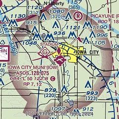
| Sectional chart |
|---|
|
CAUTION: Diagram may not be current

| Airport distance calculator |
|---|
|
|
| Sunrise and sunset |
|---|
|
Times for 19-Apr-2024
| | Local
(UTC-5) | | Zulu
(UTC) |
|---|
| Morning civil twilight | | 05:50 | | 10:50 |
| Sunrise | | 06:19 | | 11:19 |
| Sunset | | 19:51 | | 00:51 |
| Evening civil twilight | | 20:20 | | 01:20 |
|
| Current date and time |
|---|
| Zulu (UTC) | 19-Apr-2024 06:10:44 |
|---|
| Local (UTC-5) | 19-Apr-2024 01:10:44 |
|---|
|
| METAR |
|---|
| KIOW | 190552Z AUTO 31006KT 10SM CLR 05/01 A3016 RMK AO2 SLP216 T00500011 10106 20050 401110050 53016
|
KCID
16nm NW | 190552Z AUTO 32006KT 10SM CLR 02/01 A3014 RMK AO2 SLP211 T00220006 10100 20022 401060022 51016
|
|
| TAF |
|---|
KCID
16nm NW | 190524Z 1906/2006 33007KT P6SM SCT030 FM191400 29015G25KT P6SM SCT200 FM191800 29022G32KT P6SM SCT250 FM200000 29009KT P6SM FEW250
|
|
| NOTAMs |
|---|
NOTAMs are issued by the DoD/FAA and will open in a separate window not controlled by AirNav.
|
|


