FAA INFORMATION EFFECTIVE 14 MAY 2026
Location
| FAA Identifier: | AAT |
| Lat/Long: | 41-28-58.3000N 120-33-55.5000W
41-28.971667N 120-33.925000W
41.4828611,-120.5654167
(estimated) |
| Elevation: | 4378.3 ft. / 1334.5 m (surveyed) |
| Variation: | 16E (2005) |
| From city: | 1 mile W of ALTURAS, CA |
| Time zone: | UTC -7 (UTC -8 during Standard Time) |
| Zip code: | 96101 |
Airport Operations
| Airport use: | Open to the public |
| Activation date: | 10/1941 |
| Control tower: | no |
| ARTCC: | SEATTLE CENTER |
| FSS: | RENO FLIGHT SERVICE STATION |
| NOTAMs facility: | AAT (NOTAM-D service available) |
| Attendance: | 0800-1700 |
| Wind indicator: | lighted |
| Segmented circle: | yes |
| Lights: | ACTVT REIL RWY 03 & 31; VASI RWY 03; MIRL RWY 13/31; LIRL RWY 03/21 - CTAF. |
| Beacon: | white-green (lighted land airport)
Operates sunset to sunrise. |
Airport Communications
| CTAF/UNICOM: | 122.8 |
| WX ASOS: | 124.175 (530-708-6221) |
- APCH/DEP CTL SVC PRVDD BY SEATTLE ARTCC (ZSE) ON FREQS 127.6/346.35 (KLAMATH FALLS RCAG).
Airport Services
| Fuel available: | 100LL JET-A |
| Parking: | tiedowns |
| Airframe service: | NONE |
| Powerplant service: | NONE |
Runway Information
Runway 13/31
| Dimensions: | 4228 x 50 ft. / 1289 x 15 m |
| Surface: | asphalt, in good condition |
| Weight bearing capacity: | |
| Runway edge lights: | medium intensity |
| RUNWAY 13 | | RUNWAY 31 |
| Latitude: | 41-29.258548N | | 41-28.666080N |
| Longitude: | 120-34.180330W | | 120-33.694573W |
| Elevation: | 4369.1 ft. | | 4378.1 ft. |
| Traffic pattern: | right | | left |
| Runway heading: | 132 magnetic, 148 true | | 312 magnetic, 328 true |
| Markings: | nonprecision, in fair condition | | nonprecision, in fair condition |
| Runway end identifier lights: | no | | yes |
| Touchdown point: | yes, no lights | | yes, no lights |
| Obstructions: | 16 ft. road, 300 ft. from runway, 150 ft. left of centerline, 6:1 slope to clear
RY 13 APCH RATIO 28:1 FM DSPLCD THR. | | 15 ft. rr, 250 ft. from runway, 250 ft. left of centerline, 3:1 slope to clear |
Runway 3/21
| Dimensions: | 2506 x 60 ft. / 764 x 18 m |
| Surface: | asphalt, in good condition |
| Weight bearing capacity: | | Single wheel: | 12.0, GROSS PAVEMENT STRENGTH PROVIDED BY AIRPORT MANAGER. |
|
| Runway edge lights: | low intensity |
| RUNWAY 3 | | RUNWAY 21 |
| Latitude: | 41-28.845098N | | 41-29.130533N |
| Longitude: | 120-34.103887W | | 120-33.707682W |
| Elevation: | 4365.4 ft. | | 4378.0 ft. |
| Traffic pattern: | left | | right |
| Runway heading: | 030 magnetic, 046 true | | 210 magnetic, 226 true |
| Markings: | basic, in fair condition | | basic, in fair condition |
| Visual slope indicator: | 2-box VASI on left (3.00 degrees glide path) | | |
| Runway end identifier lights: | yes | | no |
| Touchdown point: | yes, no lights | | yes, no lights |
| Obstructions: | 23 ft. rr, 275 ft. from runway, 3:1 slope to clear
RWY 03 APCH RATIO 22:1 FM DSPLCD THLD. | | 20 ft. tree, 380 ft. from runway, 9:1 slope to clear
RW 21 APCH RATIO 35:1 FM DSPLCD THLD. |
Airport Ownership and Management from official FAA records
| Ownership: | Publicly-owned |
| Owner: | CITY OF ALTURAS
200 NORTH STREET
ALTURAS, CA 96101
Phone 530-233-2512
OPERD BY CITY OF ALTURAS. |
| Manager: | WARREN FARNAM
200 NORTH STREET
ALTURAS, CA 96101
Phone 530-233-2377
PUBLIC WORKS IN ALTURAS. FBO AT ARPT 530-233-5125 OR 530-708-1852. |
Additional Remarks
| - | NO TKOF RY 03 TO NE EXCP DURG ADVERSE WIND COND. 150 FT MIN ALT OVER HOUSES. |
| - | WILDLIFE REFUGES TO THE SW; SOUTH AND SE PRESENT POTENTIAL BIRD HAZARDS TO ACFT FROM OCT THRU APR. |
| - | FIRE FIGHTTING ACFT SEASONAL MAY-OCT. |
| - | ARRIVALS RY 21 DISCOURAGED DUE TO SCHOOL ON APCH. |
| - | DEER ON AND IN THE VICINITY OF ARPT. |
| - | FOR CD CTC SEATTLE ARTCC AT 253-351-3694. |
Instrument Procedures
NOTE: All procedures below are presented as PDF files. If you need a reader for these files, you should download the free Adobe Reader.NOT FOR NAVIGATION. Please procure official charts for flight.
FAA instrument procedures published for use from 14 May 2026 at 0901Z to 11 June 2026 at 0900Z.
IAPs - Instrument Approach Procedures |
|---|
| RNAV (GPS) RWY 31 **CHANGED** | |
download (190KB) |
| NOTE: Special Alternate Minimums apply | |
download (49KB) |
Departure Procedures |
|---|
| CHOIR THREE (RNAV) | |
download (140KB) |
|
|---|
| BACHS TWO (OBSTACLE) (RNAV) | |
download (218KB) |
| NOTE: Special Take-Off Minimums/Departure Procedures apply | |
download (128KB) |
Other nearby airports with instrument procedures:
KLKV - Lake County Airport (41 nm N)
KLMT - Crater Lake/Klamath Regional Airport (66 nm NW)
KSVE - Susanville Municipal Airport (66 nm S)
KAHC - Amedee Army Airfield (75 nm S)
O05 - Rogers Field Airport (78 nm SW)
|
|

Road maps at:
MapQuest
Bing
Google
| Aerial photo |
|---|
WARNING: Photo may not be current or correct
 Photo taken 07-Jul-2013
looking north-northeast.
Photo taken 07-Jul-2013
looking north-northeast.
Do you have a better or more recent aerial photo of Alturas Municipal Airport that you would like to share? If so, please send us your photo.
|
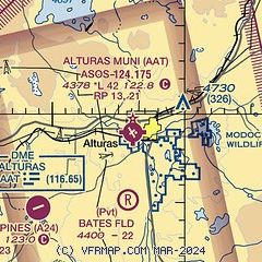
| Sectional chart |
|---|
|
| Airport distance calculator |
|---|
|
|
| Sunrise and sunset |
|---|
|
Times for 25-May-2026
| | Local
(UTC-7) | | Zulu
(UTC) |
|---|
| Morning civil twilight | | 05:03 | | 12:03 |
| Sunrise | | 05:36 | | 12:36 |
| Sunset | | 20:23 | | 03:23 |
| Evening civil twilight | | 20:55 | | 03:55 |
|
| Current date and time |
|---|
| Zulu (UTC) | 25-May-2026 21:54:46 |
|---|
| Local (UTC-7) | 25-May-2026 14:54:46 |
|---|
|
| METAR |
|---|
| KAAT | 252055Z AUTO 24021G30KT 10SM CLR 24/04 A2982 RMK AO2 PK WND 24030/2054 SLP058 T02440039 58029
|
|
| NOTAMs |
|---|
NOTAMs are issued by the DoD/FAA and will open in a separate window not controlled by AirNav.
|
|

