FAA INFORMATION EFFECTIVE 09 JULY 2026
Location
| FAA Identifier: | AVQ |
| Lat/Long: | 32-24-34.4000N 111-13-06.2000W
32-24.573333N 111-13.103333W
32.4095556,-111.2183889
(estimated) |
| Elevation: | 2031.5 ft. / 619.2 m (surveyed) |
| Variation: | 12E (2000) |
| From city: | 15 miles NW of MARANA, AZ |
| Time zone: | UTC -7 (year round; does not observe DST) |
| Zip code: | 85653 |
Airport Operations
| Airport use: | Open to the public |
| Control tower: | no |
| ARTCC: | ALBUQUERQUE CENTER |
| FSS: | PRESCOTT FLIGHT SERVICE STATION |
| NOTAMs facility: | PRC (NOTAM-D service available) |
| Attendance: | 0700-1730 |
| Wind indicator: | lighted |
| Segmented circle: | yes |
| Lights: | ACTVT REIL RWY 12 & 30; MIRL RWY 03/21 & 12/30 - CTAF. PAPI RWY 03, 12, 21 & 30 ON CONSLY. |
| Beacon: | white-green (lighted land airport)
Operates sunset to sunrise. |
Airport Communications
| CTAF/UNICOM: | 123.0 |
| WX AWOS-3: | 118.375 (520-682-1397) |
| TUCSON APPROACH: | 119.4 |
| TUCSON DEPARTURE: | 119.4 |
| WX AWOS-3PT at MZJ (8 nm NW): | 130.375 (520-682-3519) |
| WX AWOS-3 at RYN (16 nm S): | PHONE 520-578-0269 |
Nearby radio navigation aids
| VOR radial/distance | | VOR name | | Freq | | Var |
|---|
| TUSr309/24.4 | | TUCSON VORTAC | | 116.00 | | 12E |
| NDB name | | Hdg/Dist | | Freq | | Var | | ID |
|---|
| RYAN | | 338/16.5 | | 338 | | 12E | | RYN | .-. -.-- -. |
| ROBLES | | 008/21.4 | | 220 | | 12E | | RBJ | .-. -... .--- |
Airport Services
| Fuel available: | 100LL JET-A++ |
| Parking: | hangars and tiedowns |
| Airframe service: | MAJOR |
| Powerplant service: | MINOR |
| Bottled oxygen: | HIGH |
Runway Information
Runway 12/30
| Dimensions: | 6901 x 100 ft. / 2103 x 30 m |
| Surface: | asphalt, in good condition |
| Weight bearing capacity: | | Single wheel: | 75.0 | | Double wheel: | 100.0 | | Double tandem: | 300.0 |
|
| Runway edge lights: | medium intensity |
| Operational restrictions: | RWY 12 CALM WIND RWY. |
| RUNWAY 12 | | RUNWAY 30 |
| Latitude: | 32-25.060220N | | 32-24.248887N |
| Longitude: | 111-13.572588W | | 111-12.631970W |
| Elevation: | 2010.6 ft. | | 2031.4 ft. |
| Traffic pattern: | left | | right |
| Runway heading: | 123 magnetic, 135 true | | 303 magnetic, 315 true |
| Markings: | nonprecision, in good condition | | nonprecision, in good condition |
| Visual slope indicator: | 4-light PAPI on left (3.06 degrees glide path) | | 4-light PAPI on left (3.41 degrees glide path)
PAPI UNUSBL BYD 3.5 NM DUE TO TRRN. |
| Runway end identifier lights: | yes | | yes |
| Touchdown point: | yes, no lights | | yes, no lights |
Runway 3/21
| Dimensions: | 3892 x 75 ft. / 1186 x 23 m |
| Surface: | asphalt, in good condition |
| Weight bearing capacity: | | Single wheel: | 75.0 | | Double wheel: | 100.0 | | Double tandem: | 150.0 |
|
| Runway edge lights: | medium intensity |
| RUNWAY 3 | | RUNWAY 21 |
| Latitude: | 32-24.206318N | | 32-24.656318N |
| Longitude: | 111-13.372857W | | 111-12.833540W |
| Elevation: | 2019.0 ft. | | 2024.6 ft. |
| Traffic pattern: | right | | left |
| Runway heading: | 033 magnetic, 045 true | | 213 magnetic, 225 true |
| Displaced threshold: | 494 ft. | | no |
| Markings: | basic, in good condition | | basic, in good condition |
| Visual slope indicator: | 2-light PAPI on left (2.91 degrees glide path) | | 2-light PAPI on left (2.91 degrees glide path)
PAPI UNUSBL BYD 7.0 NM DUE TO TRRN. |
| Runway end identifier lights: | yes | | yes |
| Touchdown point: | yes, no lights | | yes, no lights |
| Obstructions: | 15 ft. road, 200 ft. from runway, 250 ft. right of centerline
APCH RATIO 50:1 TO DTHR. | | 13 ft. brush, 225 ft. from runway, 150 ft. right of centerline, 1:1 slope to clear |
Airport Ownership and Management from official FAA records
| Ownership: | Publicly-owned |
| Owner: | TOWN OF MARANA
11555 W. CIVIC CENTER DRIVE
MARANA, AZ 85653
Phone 520-382-1999 |
| Manager: | GALEN BEEM
11700 W. AVRA VALLEY RD, #91, TOWN OF MARANA
MARANA, AZ 85653
Phone 520-382-8053
520-382-2607 |
Additional Remarks
| - | AEROBATIC ACT 2 MI SE SFC-7000 FT MSL; HIGH & LOW LEVEL PRCHT TRNG NW QUAD. |
| - | FOR CD CTC TUCSON APCH AT 520-829-6121. |
| - | PREF TFC PAT ALT 3000 FT MSL, LIGHT ACFT; 3500 FT MSL, HEAVY ACFT. |
| - | FRMN FLT PPR WI 5 NM - AMGR. |
| - | SELF SVC CREDIT CARD FUEL H24. AFT HR CALL OUT FEE - 520-730-4318. |
| - | HOT AIR BALLON OPS NA. |
| - | HEL LND SE HELIPAD ONLY; FUEL & TERM RAMP LNDG NA. |
Instrument Procedures
NOTE: All procedures below are presented as PDF files. If you need a reader for these files, you should download the free Adobe Reader.NOT FOR NAVIGATION. Please procure official charts for flight.
FAA instrument procedures published for use from 09 July 2026 at 0901Z to 06 August 2026 at 0900Z.
IAPs - Instrument Approach Procedures |
|---|
| RNAV (GPS) RWY 03 | |
download (194KB) |
| RNAV (GPS) RWY 12 | |
download (198KB) |
| RNAV (GPS) RWY 21 | |
download (219KB) |
| RNAV (GPS)-E | |
download (175KB) |
| NOTE: Special Alternate Minimums apply | |
download (122KB) |
| NOTE: Special Take-Off Minimums/Departure Procedures apply | |
download (116KB) |
Other nearby airports with instrument procedures:
KRYN - Ryan Field Airport (16 nm S)
KDMA - Davis Monthan Air Force Base (22 nm SE)
KTUS - Tucson International Airport (22 nm SE)
P08 - Coolidge Municipal Airport (33 nm N)
KCGZ - Casa Grande Municipal Airport (43 nm NW)
|
|

Road maps at:
MapQuest
Bing
Google
| Aerial photo |
|---|
WARNING: Photo may not be current or correct
 Photo by David Evans
Photo taken 02-Feb-2013
looking northwest.
Photo by David Evans
Photo taken 02-Feb-2013
looking northwest.
Do you have a better or more recent aerial photo of Marana Regional Airport that you would like to share? If so, please send us your photo.
|
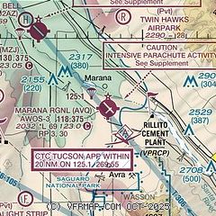
| Sectional chart |
|---|
|
| Airport distance calculator |
|---|
|
|
| Sunrise and sunset |
|---|
|
Times for 30-Jul-2026
| | Local
(UTC-7) | | Zulu
(UTC) |
|---|
| Morning civil twilight | | 05:12 | | 12:12 |
| Sunrise | | 05:39 | | 12:39 |
| Sunset | | 19:23 | | 02:23 |
| Evening civil twilight | | 19:50 | | 02:50 |
|
| Current date and time |
|---|
| Zulu (UTC) | 30-Jul-2026 21:52:55 |
|---|
| Local (UTC-7) | 30-Jul-2026 14:52:55 |
|---|
|
| METAR |
|---|
| KAVQ | 302135Z AUTO 35008KT 10SM CLR 41/12 A2987 RMK AO2
|
KMZJ
8nm NW | 302135Z AUTO 29005G13KT 10SM CLR 42/12 A2988 RMK AO2
|
KRYN
16nm S | 302045Z 29005G12KT 10SM CLR 42/11 A2992
|
|
| TAF |
|---|
KTUS
21nm SE | 301720Z 3018/3118 32008KT P6SM FEW120 SCT180 FM310500 18008KT P6SM FEW120 SCT200
|
KDMA
23nm SE | 301900Z 3019/0101 28009KT 9999 FEW160 510009 510903 QNH2990INS BECMG 3022/3023 28009KT 9999 VCTS SCT150CB QNH2990INS TEMPO 3100/3103 27012G20KT -TS BECMG 3104/3105 28009KT 9999 NSW FEW150 QNH2990INS BECMG 3108/3109 VRB06KT 9999 SCT150 QNH2998INS BECMG 3120/3121 29012G20KT 9999 FEW150 QNH2990INS TX41/3022Z TN28/3112Z
|
|
| NOTAMs |
|---|
NOTAMs are issued by the DoD/FAA and will open in a separate window not controlled by AirNav.
|
|


