FAA INFORMATION EFFECTIVE 22 JANUARY 2026
Location
| FAA Identifier: | AWG |
| Lat/Long: | 41-16-32.5000N 091-40-33.9000W
41-16.541667N 091-40.565000W
41.2756944,-91.6760833
(estimated) |
| Elevation: | 754.4 ft. / 229.9 m (surveyed) |
| Variation: | 01W (2020) |
| From city: | 2 miles SE of WASHINGTON, IA |
| Time zone: | UTC -6 (UTC -5 during Daylight Saving Time) |
| Zip code: | 52353 |
Airport Operations
| Airport use: | Open to the public |
| Activation date: | 12/1941 |
| Control tower: | no |
| ARTCC: | CHICAGO CENTER |
| FSS: | FORT DODGE FLIGHT SERVICE STATION |
| NOTAMs facility: | AWG (NOTAM-D service available) |
| Attendance: | MON-THURS 0700-1500
AVAILABLE 24/7 AT 319-653-7002 |
| Wind indicator: | lighted |
| Segmented circle: | no |
| Lights: | ACTVT MIRL RY 13/31, MIRL RY 18/36; PAPI RYS 18/36 AND 13/31 AND REIL RYS 18/36 AND 13/31- CTAF. |
| Beacon: | white-green (lighted land airport)
Operates sunset to sunrise. |
Airport Communications
| CTAF/UNICOM: | 122.7 |
| WX AWOS-3: | 127.825 (319-653-4149) |
| WX AWOS-3 at FFL (19 nm SW): | 132.025 (641-472-4548) |
- APCH/DEP SVC PRVDD BY CHICAGO ARTCC ON FREQS 135.6/370.95 (BURLINGTON RCAG).
Nearby radio navigation aids
| VOR radial/distance | | VOR name | | Freq | | Var |
|---|
| IOWr186/14.9 | | IOWA CITY VOR/DME | | 116.20 | | 05E |
| CIDr167/37.0 | | CEDAR RAPIDS VOR/DME | | 114.10 | | 05E |
Airport Services
| Fuel available: | 100LL JET-A
100LL:FUEL AVBL 24 HRS BY CREDIT CARD |
| Parking: | hangars and tiedowns |
| Airframe service: | MAJOR |
| Powerplant service: | MAJOR |
| Bottled oxygen: | NONE |
| Bulk oxygen: | HIGH |
Runway Information
Runway 18/36
| Dimensions: | 4000 x 75 ft. / 1219 x 23 m |
| Surface: | concrete/wired/combed, in good condition |
| Weight bearing capacity: | |
| Runway edge lights: | medium intensity |
| RUNWAY 18 | | RUNWAY 36 |
| Latitude: | 41-16.774295N | | 41-16.116552N |
| Longitude: | 091-40.576063W | | 091-40.622792W |
| Elevation: | 751.0 ft. | | 751.0 ft. |
| Traffic pattern: | left | | left |
| Runway heading: | 184 magnetic, 183 true | | 004 magnetic, 003 true |
| Markings: | nonprecision, in good condition | | nonprecision, in good condition |
| Visual slope indicator: | 2-light PAPI on right (4.00 degrees glide path) | | 2-light PAPI on left (3.00 degrees glide path) |
| Runway end identifier lights: | yes | | yes |
| Touchdown point: | yes, no lights | | yes, no lights |
Runway 13/31
| Dimensions: | 3401 x 60 ft. / 1037 x 18 m |
| Surface: | concrete, in excellent condition |
| Weight bearing capacity: | | PCN 5 /R/C/W/U | | Single wheel: | 28.0 |
|
| Runway edge lights: | medium intensity |
| RUNWAY 13 | | RUNWAY 31 |
| Latitude: | 41-16.850400N | | 41-16.456303N |
| Longitude: | 091-40.786318W | | 091-40.259023W |
| Elevation: | 752.7 ft. | | 754.4 ft. |
| Traffic pattern: | left | | left |
| Runway heading: | 136 magnetic, 135 true | | 316 magnetic, 315 true |
| Markings: | nonprecision, in good condition | | nonprecision, in good condition |
| Visual slope indicator: | 2-light PAPI on left (3.00 degrees glide path) | | 2-light PAPI on left (3.00 degrees glide path) |
| Runway end identifier lights: | yes | | yes |
| Touchdown point: | yes, no lights | | yes, no lights |
| Obstructions: | none | | 15 ft. road, 700 ft. from runway, 250 ft. right of centerline, 33:1 slope to clear |
Airport Ownership and Management from official FAA records
| Ownership: | Publicly-owned |
| Owner: | CITY OF WASHINGTON
215 E WASHINGTON
WASHINGTON, IA 52353
Phone 319-461-0359 |
| Manager: | KURT KUCERA
1625 SOUTH AIRPORT RD
WASHINGTON, IA 52353
Phone 319-461-0359 |
Additional Remarks
| - | RY 36 IS CALM WIND RY. |
| - | FOR CD CTC CHICAGO ARTCC AT 630-906-8921. |
Instrument Procedures
NOTE: All procedures below are presented as PDF files. If you need a reader for these files, you should download the free Adobe Reader.NOT FOR NAVIGATION. Please procure official charts for flight.
FAA instrument procedures published for use from 22 January 2026 at 0901Z to 19 February 2026 at 0900z.
IAPs - Instrument Approach Procedures |
|---|
| RNAV (GPS) RWY 13 | |
download (217KB) |
| RNAV (GPS) RWY 18 | |
download (232KB) |
| RNAV (GPS) RWY 31 | |
download (234KB) |
| RNAV (GPS) RWY 36 | |
download (226KB) |
| VOR RWY 36 | |
download (237KB) |
| NOTE: Special Alternate Minimums apply | |
download (59KB) |
| NOTE: Special Take-Off Minimums/Departure Procedures apply | |
download (239KB) |
Other nearby airports with instrument procedures:
KFFL - Fairfield Municipal Airport (19 nm SW)
KMPZ - Mount Pleasant Municipal Airport (21 nm S)
KIOW - Iowa City Municipal Airport (23 nm N)
KMUT - Muscatine Municipal Airport (24 nm E)
KOTM - Ottumwa Regional Airport (36 nm W)
|
|

Road maps at:
MapQuest
Bing
Google
| Aerial photo |
|---|
WARNING: Photo may not be current or correct
 Photo by Michael Stoneking
Photo taken 07-Jul-2009
Photo by Michael Stoneking
Photo taken 07-Jul-2009
Do you have a better or more recent aerial photo of Washington Municipal Airport that you would like to share? If so, please send us your photo.
|
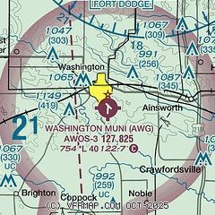
| Sectional chart |
|---|
|
| Airport distance calculator |
|---|
|
|
| Sunrise and sunset |
|---|
|
Times for 18-Feb-2026
| | Local
(UTC-6) | | Zulu
(UTC) |
|---|
| Morning civil twilight | | 06:30 | | 12:30 |
| Sunrise | | 06:58 | | 12:58 |
| Sunset | | 17:43 | | 23:43 |
| Evening civil twilight | | 18:11 | | 00:11 |
|
| Current date and time |
|---|
| Zulu (UTC) | 18-Feb-2026 18:46:47 |
|---|
| Local (UTC-6) | 18-Feb-2026 12:46:47 |
|---|
|
| METAR |
|---|
| KAWG | 181835Z AUTO 24023KT 10SM CLR 17/M10 A2955 RMK AO2
|
KFFL
20nm SW | 181830Z AUTO 24017G25KT 10SM CLR 16/M11 A2958 RMK A01
|
|
| TAF |
|---|
KOTM
36nm W | 181734Z 1818/1918 26021G30KT P6SM SKC FM182200 25017G26KT P6SM FEW250 FM190000 24010KT P6SM SCT200 FM190600 05005KT P6SM SCT200 FM190900 06007KT P6SM BKN200 FM191500 08011KT P6SM BKN100
|
KCID
37nm N | 181720Z 1818/1918 25023G35KT P6SM SKC FM190000 26014G22KT P6SM BKN250 FM190300 33006KT P6SM BKN250 FM191200 03007KT P6SM OVC250
|
KBRL
39nm SE | 181720Z 1818/1918 28017G27KT P6SM FEW250 WS020/28040KT FM182100 28013G22KT P6SM SKC FM190200 31004KT P6SM BKN250 FM191200 06007KT P6SM OVC250
|
|
| NOTAMs |
|---|
NOTAMs are issued by the DoD/FAA and will open in a separate window not controlled by AirNav.
|
|

