FAA INFORMATION EFFECTIVE 11 JUNE 2026
Location
| FAA Identifier: | BDH |
| Lat/Long: | 45-07-01.3000N 095-07-45.6000W
45-07.021667N 095-07.760000W
45.1170278,-95.1293333
(estimated) |
| Elevation: | 1126 ft. / 343.2 m (surveyed) |
| Variation: | 04E (2000) |
| From city: | 2 miles W of WILLMAR, MN |
| Time zone: | UTC -5 (UTC -6 during Standard Time) |
| Zip code: | 56201 |
Airport Operations
| Airport use: | Open to the public |
| Activation date: | 09/2006 |
| Control tower: | no |
| ARTCC: | MINNEAPOLIS CENTER |
| FSS: | PRINCETON FLIGHT SERVICE STATION |
| NOTAMs facility: | BDH (NOTAM-D service available) |
| Attendance: | 0800-1700 |
| Pattern altitude: | 2100 ft. MSL |
| Wind indicator: | lighted |
| Segmented circle: | no |
| Lights: | ACTVT OR INCR INTST MALSR RWY 13; REIL RWY 31; PAPI RWY 13 & 31; HIRL RWY 13/31 - CTAF. HIRL RWY 13/31 PRESET LOW INTST SS-SR. |
| Beacon: | white-green (lighted land airport)
Operates sunset to sunrise. |
Airport Communications
| CTAF/UNICOM: | 122.8 |
| WX AWOS-3PT: | 118.75 (320-235-8287) |
- APCH/DEP SVC PRVDD BY ZMP ON FREQS 125.5/323.1 (DARWIN RCAG).
Nearby radio navigation aids
| VOR radial/distance | | VOR name | | Freq | | Var |
|---|
| BDH at field | | WILLMAR VOR/DME | | 113.70 | | 04E |
| MVEr066/26.2 | | MONTEVIDEO VOR/DME | | 111.60 | | 05E |
| RWFr353/39.0 | | REDWOOD FALLS VOR/DME | | 113.30 | | 07E |
Airport Services
| Fuel available: | 100LL JET-A
100LL:AVBL H24 SELF SVC VIA CREDIT CARD.
A:FOR SVC AFT HRS CALL FBO AT 320-214-9669. |
| Parking: | hangars and tiedowns |
| Airframe service: | MAJOR |
| Powerplant service: | MAJOR |
| Bulk oxygen: | HIGH/LOW |
Runway Information
Runway 13/31
| Dimensions: | 5500 x 100 ft. / 1676 x 30 m |
| Surface: | asphalt, in fair condition |
| Runway edge lights: | high intensity |
| Operational restrictions: | 200 FT UNUSBL PAVEMENT BYD RWY, BOTH ENDS. |
| RUNWAY 13 | | RUNWAY 31 |
| Latitude: | 45-07.352317N | | 45-06.773870N |
| Longitude: | 095-08.429247W | | 095-07.446145W |
| Elevation: | 1123.6 ft. | | 1126.0 ft. |
| Traffic pattern: | left | | left |
| Runway heading: | 126 magnetic, 130 true | | 306 magnetic, 310 true |
| Markings: | precision, in fair condition | | precision, in fair condition |
| Visual slope indicator: | 4-light PAPI on right (3.00 degrees glide path) | | 4-light PAPI on left (3.00 degrees glide path) |
| Approach lights: | MALSR: 1,400 foot medium intensity approach lighting system with runway alignment indicator lights | | |
| Runway end identifier lights: | | | yes |
| Touchdown point: | yes, no lights | | yes, no lights |
| Instrument approach: | LOC/GS | | |
Runway 3/21
| Dimensions: | 2980 x 250 ft. / 908 x 76 m |
| Surface: | turf, in good condition |
| Runway edge markings: | YELLOW CONES. |
| Operational restrictions: | NOT PLOWED WINTER MONTHS. |
| RUNWAY 3 | | RUNWAY 21 |
| Latitude: | 45-06.744635N | | 45-07.143875N |
| Longitude: | 095-07.632807W | | 095-07.230665W |
| Elevation: | 1125.6 ft. | | 1123.0 ft. |
| Traffic pattern: | left | | left |
| Runway heading: | 031 magnetic, 035 true | | 211 magnetic, 215 true |
| Touchdown point: | yes, no lights | | yes, no lights |
Airport Ownership and Management from official FAA records
| Ownership: | Publicly-owned |
| Owner: | CITY OF WILLMAR
P.O. BOX 755
WILLMAR, MN 56201-0755
Phone 320-235-4913 |
| Manager: | ERIC RUDNINGEN
PO BOX 755, 6600 HIGHWAY 40 W
WILLMAR, MN 56201-0755
Phone 320-894-1872 |
Additional Remarks
| - | ABNDD ARPT 1 NM EAST. |
| - | FOR CD IF UNA TO CTC ON FSS FREQ, CTC MINNEAPOLIS ARTCC AT 651-463-5588. |
Instrument Procedures
NOTE: All procedures below are presented as PDF files. If you need a reader for these files, you should download the free Adobe Reader.NOT FOR NAVIGATION. Please procure official charts for flight.
FAA instrument procedures published for use from 11 June 2026 at 0901Z to 09 July 2026 at 0900z.
IAPs - Instrument Approach Procedures |
|---|
| ILS OR LOC RWY 13 **CHANGED** | |
download (237KB) |
| RNAV (GPS) RWY 13 **CHANGED** | |
download (259KB) |
| RNAV (GPS) RWY 31 **CHANGED** | |
download (245KB) |
| NOTE: Special Alternate Minimums apply **CHANGED** | |
download (176KB) |
| NOTE: Special Take-Off Minimums/Departure Procedures apply | |
download (405KB) |
Other nearby airports with instrument procedures:
KOVL - Olivia Regional Airport (21 nm S)
KPEX - Paynesville Municipal Airport (22 nm NE)
KBBB - Benson Municipal Airport (26 nm NW)
KMVE - Montevideo-Chippewa County Airport (26 nm W)
KLJF - Litchfield Municipal Airport (26 nm E)
|
|

Road maps at:
MapQuest
Bing
Google
| Aerial photo |
|---|
WARNING: Photo may not be current or correct
 Photo by Julie K. Bartley
Photo taken 10-Mar-2010
Photo by Julie K. Bartley
Photo taken 10-Mar-2010
Do you have a better or more recent aerial photo of Willmar Municipal Airport-John L Rice Field that you would like to share? If so, please send us your photo.
|
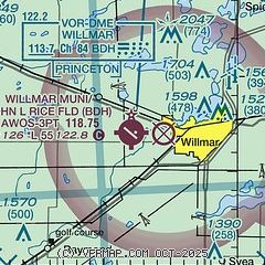
| Sectional chart |
|---|
|
| Airport distance calculator |
|---|
|
|
| Sunrise and sunset |
|---|
|
Times for 23-Jun-2026
| | Local
(UTC-5) | | Zulu
(UTC) |
|---|
| Morning civil twilight | | 04:57 | | 09:57 |
| Sunrise | | 05:35 | | 10:35 |
| Sunset | | 21:11 | | 02:11 |
| Evening civil twilight | | 21:48 | | 02:48 |
|
| Current date and time |
|---|
| Zulu (UTC) | 24-Jun-2026 01:03:03 |
|---|
| Local (UTC-5) | 23-Jun-2026 20:03:03 |
|---|
|
| METAR |
|---|
| KBDH | 240055Z AUTO 09008KT 10SM SCT011 SCT060 20/19 A3003 RMK AO2 LTG DSNT SE AND S P0001
|
|
| TAF |
|---|
KRWF
34nm S | 232101Z 2321/2418 25012G18KT 6SM -SHRA SCT050 BKN070 FM240200 23007KT P6SM BKN050 FM241300 29007KT P6SM FEW120 FM241600 29012G19KT P6SM FEW120
|
|
| NOTAMs |
|---|
NOTAMs are issued by the DoD/FAA and will open in a separate window not controlled by AirNav.
|
|

