FAA INFORMATION EFFECTIVE 11 JUNE 2026
Location
| FAA Identifier: | BFI |
| Lat/Long: | 47-31-47.9000N 122-18-07.0000W
47-31.798333N 122-18.116667W
47.5299722,-122.3019444
(estimated) |
| Elevation: | 21.6 ft. / 6.6 m (surveyed) |
| Variation: | 15E (2020) |
| From city: | 4 miles S of SEATTLE, WA |
| Time zone: | UTC -7 (UTC -8 during Standard Time) |
| Zip code: | 98108 |
Airport Operations
| Airport use: | Open to the public |
| Activation date: | 11/1938 |
| Control tower: | yes |
| ARTCC: | SEATTLE CENTER |
| FSS: | SEATTLE FLIGHT SERVICE STATION |
| NOTAMs facility: | BFI (NOTAM-D service available) |
| Attendance: | CONTINUOUS |
| Wind indicator: | lighted |
| Segmented circle: | no |
| Lights: | HIRL RY 14R/32L OPEN DUSK-DAWN. MIRL RY 14L/32R NOT OPER 0600-1500Z++. |
| Beacon: | white-green (lighted land airport)
Operates sunset to sunrise. |
| Landing fee: | yes |
| Fire and rescue: | ARFF index C |
| International operations: | international airport of entry |
Airport Communications
| UNICOM: | 122.95 |
| ATIS: | 127.75 |
| WX ASOS: | PHONE 206-658-6435 |
| BOEING GROUND: | 121.9 |
| BOEING TOWER: | 118.3 ;RWY 14L/32R 120.6 ;RWY 14R/32L & ALL IFR 257.8 |
| SEATTLE APPROACH: | 119.2 ;017-079 SEA, RWY 32 119.2 ;028-160 SEA RWY 14 120.1 ;223-289 SEA, RWY 14 120.1 ;223-301 SEA, RWY 32 120.4 ;301-340 SEA. RWY 32 125.9 125.9 ;080-125 SEA, RWY 32 125.9 ;080-125 SEA,RWY 32 125.9 ;290-315 SEA, RWY 14 126.5 ;126-222 SEA, RWY 32 126.5 ;161-222 SEA RWY 14 128.5 ;302-016 SEA, RWY 32 128.5 ;316-027 SEA, RWY 14 |
| SEATTLE DEPARTURE: | 119.2 ;017-079 SEA, RWY 32 119.2 ;028-160 SEA RWY 14 120.1 ;223-289 SEA, RWY 14 120.1 ;223-301 SEA, RWY 32 120.4 ;301-340 SEA. RWY 32 125.9 ;080-125 SEA, RWY 32 125.9 ;080-125 SEA,RWY 32 125.9 ;290-315 SEA, RWY 14 126.5 ;126-222 SEA, RWY 32 126.5 ;161-222 SEA RWY 14 128.5 ;302-016 SEA, RWY 32 128.5 ;316-027 SEA, RWY 14 |
| CLEARANCE DELIVERY: | 132.4 |
| CBAIN RNAV DP: | 120.4 |
| CLASS B: | 119.2 ;017-079 SEA, RWY 32 119.2 ;028-160 SEA RWY 14 120.1 ;223-289 SEA, RWY 14 120.1 ;223-301 SEA, RWY 32 125.9 ;080-125 SEA RWY 32 125.9 ;290-315 SEA RWY 14 126.5 ;126-222 SEA, RWY 32 126.5 ;161-222 SEA, RWY 14 128.5 ;302-016 SEA, RWY 32 128.5 ;316-027 SEA, RWY 14 |
| GLASR STAR: | 123.9 |
| IC: | 125.9 |
| JAWBN STAR: | 125.6 |
| KENT DP: | 119.2 |
| NEEDLE DP: | 120.4 |
| NRVNA RNAV DP: | 119.2 |
| OLYMPIA STAR: | 125.6 |
| WX ASOS at RNT (4 nm SE): | 126.95 (425-255-6080) |
| WX ASOS at SEA (5 nm S): | PHONE 206-214-2592 |
| WX AWOS-3PT at PWT (19 nm W): | 121.2 (360-674-2811) |
| WX ASOS at TIW (19 nm SW): | PHONE 253-858-6507 |
- FREQ 121.5 NOT AVBL.
- FREQ 118.3 (312-127) AND DEPS RWY 14L/32R.
- FREQ 120.6 (128-311) AND DEPS RWY 14R/32L AND ALL JETS; HEAVY ACFT AND IFR ARRS.
- SAID IN USE. OPERATE TRANSPONDERS WITH ALTITUDE REPORTING MODE AND ADS-B (IF EQUIPPED) ENABLED ON ALL AIRPORT SURFACES.
Nearby radio navigation aids
| VOR radial/distance | | VOR name | | Freq | | Var |
|---|
| SEAr344/5.7 | | SEATTLE VORTAC | | 116.80 | | 19E |
| PAEr162/23.4 | | PAINE VOR/DME | | 110.60 | | 20E |
Airport Services
| Fuel available: | 100LL JET-A |
| Parking: | hangars and tiedowns |
| Airframe service: | MAJOR |
| Powerplant service: | MAJOR |
| Bottled oxygen: | HIGH/LOW |
| Bulk oxygen: | HIGH/LOW |
Runway Information
Runway 14R/32L
| Dimensions: | 10007 x 200 ft. / 3050 x 61 m |
| Surface: | asphalt/grooved, in good condition |
| Weight bearing capacity: | | Single wheel: | 100.0 | | Double wheel: | 200.0 | | Double tandem: | 500.0 | | Dual double tandem: | 800.0 |
|
| Runway edge lights: | high intensity |
| RUNWAY 14R | | RUNWAY 32L |
| Latitude: | 47-32.432570N | | 47-31.004198N |
| Longitude: | 122-18.681257W | | 122-17.473663W |
| Elevation: | 17.8 ft. | | 21.0 ft. |
| Traffic pattern: | right | | left |
| Runway heading: | 135 magnetic, 150 true | | 315 magnetic, 330 true |
| Displaced threshold: | no | | 887 ft. |
| Declared distances: | TORA:10000 TODA:10000 ASDA:9120 LDA:9120 | | TORA:10000 TODA:10000 ASDA:10000 LDA:9120 |
| Markings: | precision, in good condition | | precision, in good condition |
| Visual slope indicator: | 4-light PAPI on left (3.00 degrees glide path) | | 4-light PAPI on left (3.10 degrees glide path) |
| RVR equipment: | touchdown, rollout | | touchdown, rollout |
| Approach lights: | MALSF: 1,400 foot medium intensity approach lighting system with sequenced flashers | | |
| Runway end identifier lights: | | | yes |
| Touchdown point: | yes, no lights | | yes, no lights |
| Instrument approach: | ILS/DME | | ILS/DME |
| Obstructions: | 12 ft. fence, 240 ft. from runway, 425 ft. right of centerline, 3:1 slope to clear | | 27 ft. rr, 200 ft. from runway, 375 ft. right of centerline, 40:1 slope to clear
FENCE/ROAD/POLES/RR TRACKS WITHIN EAST EDGE OF PRIM SFC. |
Runway 14L/32R
| Dimensions: | 3709 x 100 ft. / 1131 x 30 m |
| Surface: | asphalt/grooved, in fair condition |
| Weight bearing capacity: | | Single wheel: | 120.0, LTD TO USE BY ACFT UP TO 12,500 LBS. | | Double wheel: | 250.0 | | Double tandem: | 550.0 | | Dual double tandem: | 1109.0 |
|
| Runway edge lights: | medium intensity |
| Operational restrictions: | RWY 14L/32R NOT AVBL FOR PART 121/PART 380 OPS WITH SKED PAX CARRYING OPS MORE THAN 9 PAX SEATS AND NON-SKED PAX CARRYING OPS MORE THAN 30 PAX SEATS. |
| RUNWAY 14L | | RUNWAY 32R |
| Latitude: | 47-32.281095N | | 47-31.751612N |
| Longitude: | 122-18.447615W | | 122-18.000033W |
| Elevation: | 17.4 ft. | | 17.1 ft. |
| Traffic pattern: | left | | right |
| Runway heading: | 135 magnetic, 150 true | | 315 magnetic, 330 true |
| Displaced threshold: | 250 ft. | | 375 ft. |
| Markings: | basic, in good condition | | basic, in good condition |
| Visual slope indicator: | 2-light PAPI on left (3.00 degrees glide path) | | 2-light PAPI on left (3.00 degrees glide path) |
| Runway end identifier lights: | yes | | yes |
| Touchdown point: | yes, no lights | | yes, no lights |
| Obstructions: | none | | 210 ft. tree, 5000 ft. from runway, 625 ft. right of centerline, 22:1 slope to clear
APCH RATIO 27:1 FM DSPLCD THLD. |
Airport Ownership and Management from official FAA records
| Ownership: | Publicly-owned |
| Owner: | KING COUNTY
516 THIRD AVE
SEATTLE, WA 98104
Phone (206) 296-7380 |
| Manager: | JOHN PARROTT, AAE
7277 PERIMETER ROAD SOUTH
SEATTLE, WA 98108-3844
Phone 206-296-7334
JPARROTT@KINGCOUNTY.GOV. |
Additional Remarks
| A39-14R/32L | PCR VALUE: 770/R/C/W/T |
| A39-14L/32R | PCR VALUE: 310/F/B/X/T |
| - | GA ITNRNT/TSNT PRKG AVBL. CTC ARPT OPS 206-296-7334. |
| - | TWR 80 FT AGL LCTD 1200 FT N AND 900 FT W OF THLD RY 14R. |
| - | FOR NOISE ABATEMENT PROCEDURES, CONTACT NOISE OFFICE AT (206) 296-7334. |
| - | EXTENSIVE HELICOPTER TRAINING ACTIVITY ON TAXIWAY B. |
| - | FOR MUSEUM OF FLT TSNT ACFT PRKG, PPR, CALL MUSEUM OF FLT SCTY (206) 920-9770. |
| - | TAXIWAY ZULU AND 880' SPECIAL USE PAVEMENT AVAILABLE 72 HOURS PRIOR PERMISSION REQUIRED. CONTACT AIRPORT OPERATIONS 206-296-7334. |
| - | TPA RWY 14L/32R 1000 MSL; RWY 14R/32L 800 MSL. |
| - | EMERG FREQ 121.5 NOT MNT AT TWR. |
| - | FOR BOEING MILITARY FLIGHT CENTER RAMP PERMISSION, CTC RAMP COORDINATOR 206-225-0989, 72 HOUR PRIOR PERMISSION REQUIRED, 96 HOUR PRIOR PERMISSION REQUIRED IF ORDNANCES/MUNITIONS INSTALLED OR IF ORDNANCES/MUNITIONS STORAGE IS REQUIRED. LIMITED LOX SERVICE MEETING MIL-PRF-27210J, TYPE II AVAILABLE FOR MILITARY FLIGHT CENTER TRANSIENT AIRCRAFT, CONTACT 96 HOURS PRIOR WITH NEEDED VOLUME AND AIRCRAFT TYPE. PRIOR TO ARRIVAL ONTO BOEING COMMERCIAL AIRPLANE RAMP, CTC BOEING SEATTLE AT 123.425 OR CALL 206-662-4500. ADVANCED PERMISSION TO ACCESS BOEING COMMERCIAL AIRPLANE RAMP ONLY, CTC 206-544-5900 M-F 1600Z-0000Z. |
| - | FOR CD WHEN ATCT IS CLSD CTC SEATTLE APCH AT 206-214-4722. |
| - | VFR PILOTS SHLD REVIEW & EXPC VFR PROCS PRIOR TO ARR/DEP. |
| - | TOUCH AND GO LNDGS PROHIBITED 2200-0700. |
| - | BIRD FLOCKS WITHIN ARPT VICINITY. - CHECK LOCAL ADVISORIES. |
| - | FLIGHT NOTIFICATION SERVICE (ADCUS) AVBL. |
| - | 14' ANT (MKD/LGTD) 230' FM RY 14L END 125' R. |
| - | TWY A1 & TWY A FROM A1-A3 RSTRD TO ACFT UP TO 150000 LBS AND LESS THAN 108 FT WINGSPAN. |
| - | TWYS A2; A4: A6; &B2 RSTD TO ACFT UP TO 12500 LBS. TWY A9 RSTD TO ACFT UP TO 60000LBS. |
Instrument Procedures
NOTE: All procedures below are presented as PDF files. If you need a reader for these files, you should download the free Adobe Reader.NOT FOR NAVIGATION. Please procure official charts for flight.
FAA instrument procedures published for use from 11 June 2026 at 0901Z to 09 July 2026 at 0900z.
STARs - Standard Terminal Arrivals |
|---|
| CHINS FIVE **NEW** | |
2 pages:
[1] [2] (344KB) |
| GLASR THREE **NEW** | |
2 pages:
[1] [2] (366KB) |
| JAWBN SEVEN **NEW** | |
download (195KB) |
| OLYMPIA TWO **NEW** | |
2 pages:
[1] [2] (303KB) |
| SKYKO ONE **NEW** | |
download (232KB) |
IAPs - Instrument Approach Procedures |
|---|
| ILS OR LOC RWY 14R | |
download (349KB) |
| ILS OR LOC RWY 32L | |
download (282KB) |
| RNAV (RNP) Z RWY 14R | |
download (303KB) |
| RNAV (RNP) Z RWY 32L | |
download (284KB) |
| RNAV (GPS) Y RWY 14R | |
download (313KB) |
| RNAV (GPS) Y RWY 32L | |
download (295KB) |
| HARBOR VISUAL RWY 14R | |
download (267KB) |
| NOTE: Special Alternate Minimums apply | |
download (212KB) |
Departure Procedures |
|---|
| CBAIN ONE (RNAV) | |
download (249KB) |
| KENT ONE | |
download (219KB) |
| NEEDLE THREE | |
download (174KB) |
| NRVNA ONE (RNAV) | |
download (232KB) |
| NOTE: Special Take-Off Minimums/Departure Procedures apply | |
download (530KB) |
Other nearby airports with instrument procedures:
KRNT - Renton Municipal Airport (4 nm SE)
KSEA - Seattle-Tacoma International Airport (5 nm S)
S50 - Auburn Municipal Airport (13 nm S)
KPWT - Bremerton National Airport (19 nm W)
KTIW - Tacoma Narrows Airport (19 nm SW)
|
|

Road maps at:
MapQuest
Bing
Google
| Aerial photo |
|---|
WARNING: Photo may not be current or correct
 Photo by Trent Thomas
Photo taken 24-Aug-2022
facing NW at 7,500 MSL.
Photo by Trent Thomas
Photo taken 24-Aug-2022
facing NW at 7,500 MSL.
Do you have a better or more recent aerial photo of Boeing Field/King County International Airport that you would like to share? If so, please send us your photo.
|
| Sectional chart |
|---|
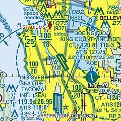
|
CAUTION: Diagram may not be current
 Download PDF
of official airport diagram from the FAA
| Airport distance calculator |
|---|
|
|
| Sunrise and sunset |
|---|
|
Times for 01-Jul-2026
| | Local
(UTC-7) | | Zulu
(UTC) |
|---|
| Morning civil twilight | | 04:37 | | 11:37 |
| Sunrise | | 05:17 | | 12:17 |
| Sunset | | 21:09 | | 04:09 |
| Evening civil twilight | | 21:49 | | 04:49 |
|
| Current date and time |
|---|
| Zulu (UTC) | 01-Jul-2026 08:07:23 |
|---|
| Local (UTC-7) | 01-Jul-2026 01:07:23 |
|---|
|
| METAR |
|---|
| KBFI | 010753Z 17006KT 10SM FEW036 13/09 A3006 RMK AO2 SLP177 T01280089 401780122
|
KRNT
4nm SE | 010753Z AUTO 20004KT 10SM OVC036 14/09 A3006 RMK AO2 SLP183 T01390089 401780128
|
KSEA
5nm S | 010753Z 21006KT 10SM FEW017 BKN032 12/08 A3006 RMK AO2 SLP186 T01220083 401780111 $
|
KPWT
18nm W | 010756Z AUTO 20004KT 10SM SCT012 11/10 A3005 RMK AO2 SLP181 T01110100 401610111
|
KTIW
19nm SW | 010753Z AUTO 21005KT 10SM SCT021 BKN034 12/09 A3006 RMK AO2 SLP179 T01170089
|
|
| TAF |
|---|
| KBFI | 010522Z 0106/0206 20005KT P6SM SCT040 BKN070 FM011000 17006KT P6SM BKN030 FM011500 18007KT P6SM SCT008 OVC025 FM012100 20006KT P6SM SCT030 BKN040 FM020300 VRB03KT P6SM BKN050
|
KSEA
5nm S | 010522Z 0106/0212 22005KT P6SM SCT040 BKN060 FM011000 19007KT P6SM BKN025 FM011500 20008KT P6SM SCT008 OVC015 FM012100 23008KT P6SM SCT025 BKN035 FM020300 26005KT P6SM BKN040
|
KPWT
18nm W | 010522Z 0106/0206 20007KT P6SM OVC025 FM011000 VRB03KT P6SM OVC010 FM011600 21005KT P6SM OVC015 FM012100 20006KT P6SM SCT020 BKN040 FM020300 19005KT P6SM BKN050
|
|
| NOTAMs |
|---|
NOTAMs are issued by the DoD/FAA and will open in a separate window not controlled by AirNav.
|
|


