FAA INFORMATION EFFECTIVE 11 JUNE 2026
Location
| FAA Identifier: | BJI |
| Lat/Long: | 47-30-38.6000N 094-56-05.0000W
47-30.643333N 094-56.083333W
47.5107222,-94.9347222
(estimated) |
| Elevation: | 1391.4 ft. / 424.1 m (surveyed) |
| Variation: | 01E (2015) |
| From city: | 3 miles NW of BEMIDJI, MN |
| Time zone: | UTC -5 (UTC -6 during Standard Time) |
| Zip code: | 56601 |
Airport Operations
| Airport use: | Open to the public |
| Activation date: | 09/1946 |
| Control tower: | no |
| ARTCC: | MINNEAPOLIS CENTER |
| FSS: | PRINCETON FLIGHT SERVICE STATION |
| NOTAMs facility: | BJI (NOTAM-D service available) |
| Attendance: | TUE-FRI 0600-2100, ALL SAT-SUN 0800-1700, ALL MON 0700-2100 |
| Wind indicator: | lighted |
| Segmented circle: | no |
| Lights: | HIRL RY 13/31 PRESET ON LOW INTST; TO INCR INTST & ACTVT REIL RY 07/25; MIRL RY 07/25; MALSR RY 13/31; HIRL RY 13/31 - CTAF. PAPI RY 07, RY 25, RY 13 AND RY 31 OPR CONTINUOUSLY. |
| Beacon: | white-green (lighted land airport)
Operates sunset to sunrise. |
| Fire and rescue: | ARFF index A |
| Airline operations: | 48 HR PPR FOR UNSKED ACR OPNS WITH MORE THAN 30 PSGR SEATS, CALL AMGR 218-444-2438. |
Airport Communications
| CTAF/UNICOM: | 122.8 |
| WX AWOS-3: | 119.275 (218-755-2575) |
- APCH/DEP SVC PRVDD BY MINNEAPOLIS ARTCC (ZMP) ON FREQS 134.75/251.1 (BEMIDJI RCAG).
Nearby radio navigation aids
| VOR radial/distance | | VOR name | | Freq | | Var |
|---|
| IDJ at field | | LAKE BEMIDJI VOR/DME | | 110.00 | | 01E |
Airport Services
| Fuel available: | 100LL JET-A |
| Parking: | hangars and tiedowns |
| Airframe service: | MAJOR |
| Powerplant service: | MAJOR |
| Bottled oxygen: | HIGH/LOW |
| Bulk oxygen: | NONE |
Runway Information
Runway 13/31
| Dimensions: | 7004 x 150 ft. / 2135 x 46 m |
| Surface: | asphalt/grooved, in excellent condition |
| Weight bearing capacity: | | Single wheel: | 75.0 | | Double wheel: | 200.0 |
|
| Runway edge lights: | high intensity |
| RUNWAY 13 | | RUNWAY 31 |
| Latitude: | 47-31.106735N | | 47-30.306525N |
| Longitude: | 094-56.808098W | | 094-55.585013W |
| Elevation: | 1391.2 ft. | | 1384.2 ft. |
| Traffic pattern: | left | | left |
| Runway heading: | 133 magnetic, 134 true | | 313 magnetic, 314 true |
| Declared distances: | TORA:7002 TODA:7002 ASDA:7002 LDA:7002 | | TORA:7002 TODA:7002 ASDA:7002 LDA:7002 |
| Markings: | precision, in good condition | | precision, in good condition |
| Visual slope indicator: | 4-light PAPI on left (3.00 degrees glide path) | | 4-light PAPI on left (3.00 degrees glide path) |
| Approach lights: | MALSR: 1,400 foot medium intensity approach lighting system with runway alignment indicator lights | | MALSR: 1,400 foot medium intensity approach lighting system with runway alignment indicator lights |
| Runway end identifier lights: | no | | no |
| Touchdown point: | yes, no lights | | yes, no lights |
| Instrument approach: | | | ILS |
| Obstructions: | 68 ft. trees, 2278 ft. from runway, 362 ft. left of centerline, 30:1 slope to clear | | none |
Runway 7/25
| Dimensions: | 5700 x 150 ft. / 1737 x 46 m |
| Surface: | asphalt/grooved, in excellent condition |
| Weight bearing capacity: | | Single wheel: | 86.0 | | Double wheel: | 150.0 | | Double tandem: | 269.0 |
|
| Runway edge lights: | medium intensity |
| RUNWAY 7 | | RUNWAY 25 |
| Latitude: | 47-30.434870N | | 47-30.693322N |
| Longitude: | 094-56.610138W | | 094-55.279985W |
| Elevation: | 1383.9 ft. | | 1379.9 ft. |
| Traffic pattern: | left | | left |
| Runway heading: | 073 magnetic, 074 true | | 253 magnetic, 254 true |
| Declared distances: | TORA:5700 TODA:5700 ASDA:5700 LDA:5700 | | TORA:5700 TODA:5700 ASDA:5700 LDA:5700 |
| Markings: | nonprecision, in good condition | | precision, in good condition |
| Visual slope indicator: | 4-light PAPI on left (3.00 degrees glide path) | | 4-light PAPI on left (3.00 degrees glide path) |
| Runway end identifier lights: | yes | | yes |
| Touchdown point: | yes, no lights | | yes, no lights |
| Instrument approach: | | | ILS/DME |
| Obstructions: | none | | 35 ft. trees, 1294 ft. from runway, 600 ft. right of centerline, 31:1 slope to clear |
Airport Ownership and Management from official FAA records
| Ownership: | Publicly-owned |
| Owner: | CITY OF BEMIDJI / BELTRAMI CO
3824 MOBERG DRIVE, STE. 101
BEMIDJI, MN 56601
Phone 218-444-2438 |
| Manager: | KYLE CHRISTIANSEN
3824 MOBERG DRIVE, STE 101
BEMIDJI, MN 56601
Phone 218-558-5190
APT MAINT SUPVR, PHONE 218-558-5190. APRT DIRECTOR EMAIL KYLE.CHRISTIANSEN@BEMIDJIAIRPORT.ORG . |
Additional Remarks
| A39-13/31 | PCR VALUE: 380/F/A/X/T |
| A39-07/25 | PCR VALUE: 310/F/A/X/T |
| - | DEER & BIRDS ON & INVOF ARPT. |
| - | SNOW REMOVAL CREWS MONTR CTAF DURG ALL ACR OPS FOR AIRFIELD COND INFO. |
| - | ARFF CREWS MONTR CTAF DURG ALL ACR OPS. |
| - | FOR CD IF UNA TO CTC ON FSS FREQ, CTC MINNEAPOLIS ARTCC AT 651-463-5588. |
Instrument Procedures
NOTE: All procedures below are presented as PDF files. If you need a reader for these files, you should download the free Adobe Reader.NOT FOR NAVIGATION. Please procure official charts for flight.
FAA instrument procedures published for use from 11 June 2026 at 0901Z to 09 July 2026 at 0900z.
IAPs - Instrument Approach Procedures |
|---|
| ILS OR LOC RWY 25 | |
download (229KB) |
| ILS OR LOC RWY 31 | |
download (246KB) |
| RNAV (GPS) RWY 13 | |
download (221KB) |
| RNAV (GPS) RWY 25 | |
download (260KB) |
| RNAV (GPS) RWY 31 | |
download (251KB) |
| VOR/DME RWY 13 | |
download (232KB) |
| NOTE: Special Alternate Minimums apply | |
download (27KB) |
| NOTE: Special Take-Off Minimums/Departure Procedures apply | |
download (156KB) |
Other nearby airports with instrument procedures:
Y49 - Walker Municipal Airport (24 nm SE)
KFSE - Fosston Municipal Airport/Anderson Field (34 nm W)
KPKD - Park Rapids Municipal Airport-Konshok Field (37 nm S)
3N8 - Mahnomen County Airport (43 nm W)
KXVG - Longville Municipal Airport (43 nm SE)
|
|

Road maps at:
MapQuest
Bing
Google
| Aerial photo |
|---|
WARNING: Photo may not be current or correct
 Photo by Mark Robinson
Photo taken 20-Aug-2021
looking SW.
Photo by Mark Robinson
Photo taken 20-Aug-2021
looking SW.
Do you have a better or more recent aerial photo of Bemidji Regional Airport that you would like to share? If so, please send us your photo.
|
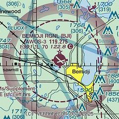
| Sectional chart |
|---|
|
| Airport distance calculator |
|---|
|
|
| Sunrise and sunset |
|---|
|
Times for 22-Jun-2026
| | Local
(UTC-5) | | Zulu
(UTC) |
|---|
| Morning civil twilight | | 04:43 | | 09:43 |
| Sunrise | | 05:24 | | 10:24 |
| Sunset | | 21:20 | | 02:20 |
| Evening civil twilight | | 22:00 | | 03:00 |
|
| Current date and time |
|---|
| Zulu (UTC) | 22-Jun-2026 15:07:16 |
|---|
| Local (UTC-5) | 22-Jun-2026 10:07:16 |
|---|
|
| METAR |
|---|
| KBJI | 221455Z AUTO 08004KT 10SM CLR 18/07 A3015 RMK AO2 T01840067
|
|
| TAF |
|---|
| KBJI | 221120Z 2212/2312 VRB03KT P6SM SCT150
|
|
| NOTAMs |
|---|
NOTAMs are issued by the DoD/FAA and will open in a separate window not controlled by AirNav.
|
|

