FAA INFORMATION EFFECTIVE 25 DECEMBER 2025
Location
| FAA Identifier: | BML |
| Lat/Long: | 44-34-31.3000N 071-10-33.3000W
44-34.521667N 071-10.555000W
44.5753611,-71.1759167
(estimated) |
| Elevation: | 1161.3 ft. / 354.0 m (surveyed) |
| Variation: | 16W (2010) |
| From city: | 7 miles N of BERLIN, NH |
| Time zone: | UTC -5 (UTC -4 during Daylight Saving Time) |
| Zip code: | 03588 |
Airport Operations
| Airport use: | Open to the public |
| Activation date: | 12/1946 |
| Control tower: | no |
| ARTCC: | BOSTON CENTER |
| FSS: | BANGOR FLIGHT SERVICE STATION |
| NOTAMs facility: | BML (NOTAM-D service available) |
| Attendance: | 0800-1600 |
| Wind indicator: | lighted |
| Segmented circle: | no |
| Lights: | ACTVT REIL RWY 18 & 36, PAPI RWY 18, HIRL RWY 18/36 - CTAF. |
| Beacon: | white-green (lighted land airport)
Operates sunset to sunrise. |
| Landing fee: | no, CORPORATE AND CHTR ACFT LDG FEE FOR ALL PISTON, TURBOPROP & JET ACFT. LDG FEE WAIVED WITH FUEL PURCHASE & OVNGT PRKG, CORPORATE & CHTR ACFT OVNGT PRKG FEE. CTC AMGR. |
Airport Communications
| CTAF/UNICOM: | 122.7 |
| WX ASOS: | 135.175 (603-449-3328) |
| WX AWOS-AV at 0B1 (18 nm SE): | 119.075 (207-512-2516) |
- APCH/DEP SVC PRVDD BY BOSTON ARTCC ON FREQS 135.7/282.2 (BERLIN RCAG).
Nearby radio navigation aids
| NDB name | | Hdg/Dist | | Freq | | Var | | ID |
|---|
| MAHN | | 077/25.3 | | 386 | | 17W | | GMA | --. -- .- |
Airport Services
| Fuel available: | 100LL JET-A
100LL:SELF-SERVE 100LL AVBL 24 HRS WITH CREDIT CARD SYSTEM. FOR JET A AFTER HRS CALL 603-915-0214. |
| Parking: | tiedowns |
| Airframe service: | MINOR |
| Powerplant service: | MINOR |
| Bottled oxygen: | NONE |
| Bulk oxygen: | NONE |
Runway Information
Runway 18/36
| Dimensions: | 5200 x 100 ft. / 1585 x 30 m |
| Surface: | asphalt, in good condition |
| Weight bearing capacity: | | Single wheel: | 53.0 | | Double wheel: | 82.0 | | Double tandem: | 140.0 |
|
| Runway edge lights: | high intensity |
| RUNWAY 18 | | RUNWAY 36 |
| Latitude: | 44-34.921758N | | 44-34.122420N |
| Longitude: | 071-10.769483W | | 071-10.341882W |
| Elevation: | 1161.3 ft. | | 1130.4 ft. |
| Traffic pattern: | left | | left |
| Runway heading: | 175 magnetic, 159 true | | 355 magnetic, 339 true |
| Markings: | nonprecision, in good condition | | nonprecision, in good condition |
| Visual slope indicator: | 4-light PAPI on left (3.50 degrees glide path) | | |
| Runway end identifier lights: | yes | | yes |
| Touchdown point: | yes, no lights | | yes, no lights |
| Obstructions: | 17 ft. trees, 335 ft. from runway, 115 ft. left of centerline, 7:1 slope to clear | | 51 ft. trees, 711 ft. from runway, 151 ft. right of centerline, 10:1 slope to clear |
Airport Ownership and Management from official FAA records
| Ownership: | Publicly-owned |
| Owner: | CITY OF BERLIN
168 MAIN ST
BERLIN, NH 03570
Phone 603-752-7532 |
| Manager: | MARCEL LEVEILLE
800 EAST SIDE RIVER RD.
MILAN, NH 03588
Phone 603-449-2168
AMGR AFT HRS FONE 603-915-0214. |
Additional Remarks
| - | OBSTN LGTS ON ANT POLES; HAZARD BCNS ON SURROUNDING HILLS. |
| - | WILDLIFE ON & INVOF ARPT. |
| - | COLD TEMPERATURE AIRPORT. ALTITUDE CORRECTION REQUIRED AT OR BELOW -28C. |
| - | FOR CD IF UNA TO CTC ON FSS FREQ, CTC BOSTON ARTCC AT 603-879-6859. |
| - | RENTAL CARS & CATERING AVBL BY REQ, CALL 603-915-0214. |
Instrument Procedures
NOTE: All procedures below are presented as PDF files. If you need a reader for these files, you should download the free Adobe Reader.NOT FOR NAVIGATION. Please procure official charts for flight.
FAA instrument procedures published for use from 25 December 2025 at 0901z to 22 January 2026 at 0900z.
IAPs - Instrument Approach Procedures |
|---|
| RNAV (GPS) RWY 18 | |
download (253KB) |
| NOTE: Special Alternate Minimums apply | |
download (153KB) |
| NOTE: Special Take-Off Minimums/Departure Procedures apply | |
download (510KB) |
Other nearby airports with instrument procedures:
0B1 - Bethel Regional Airport (18 nm SE)
KHIE - Mount Washington Regional Airport (20 nm SW)
M57 - Rangeley Lake Seaplane Base (31 nm NE)
8B0 - Stephen A Bean Municipal Airport (33 nm NE)
KCDA - Caledonia County Airport (36 nm W)
|
|

Road maps at:
MapQuest
Bing
Google
| Aerial photo |
|---|
WARNING: Photo may not be current or correct
 Photo by Pete Chaisson- Portland Flight Services
Photo taken 21-Aug-2014
looking west.
Photo by Pete Chaisson- Portland Flight Services
Photo taken 21-Aug-2014
looking west.
Do you have a better or more recent aerial photo of Berlin Regional Airport that you would like to share? If so, please send us your photo.
|
| Sectional chart |
|---|
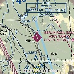
|
| Airport distance calculator |
|---|
|
|
| Sunrise and sunset |
|---|
|
Times for 14-Jan-2026
| | Local
(UTC-5) | | Zulu
(UTC) |
|---|
| Morning civil twilight | | 06:47 | | 11:47 |
| Sunrise | | 07:20 | | 12:20 |
| Sunset | | 16:28 | | 21:28 |
| Evening civil twilight | | 17:01 | | 22:01 |
|
| Current date and time |
|---|
| Zulu (UTC) | 15-Jan-2026 03:55:01 |
|---|
| Local (UTC-5) | 14-Jan-2026 22:55:01 |
|---|
|
| METAR |
|---|
| KBML | 150333Z AUTO 00000KT 6SM -RA BR SCT025 OVC030 01/M01 A2950 RMK AO2 P0001 T00061006
|
KMWN
19nm S | 150255Z 22030KT 1/16SM -SN FZFG DRSN VV000 M03/M03 RMK VRY LGT ICG
|
|
| TAF |
|---|
KHIE
20nm SW | 141724Z 1418/1518 00000KT P6SM SKC FM150000 00000KT P6SM -RA OVC050 FM150300 00000KT 2SM -RA BR OVC015 FM151600 16002KT 6SM BR OVC007
|
|
| NOTAMs |
|---|
NOTAMs are issued by the DoD/FAA and will open in a separate window not controlled by AirNav.
|
|

