FAA INFORMATION EFFECTIVE 11 JUNE 2026
Location
| FAA Identifier: | BXA |
| Lat/Long: | 30-48-49.2710N 089-51-53.8720W
30-48.821183N 089-51.897867W
30.8136864,-89.8649644
(estimated) |
| Elevation: | 119 ft. / 36.3 m (surveyed) |
| Variation: | 00W (2010) |
| From city: | 2 miles N of BOGALUSA, LA |
| Time zone: | UTC -5 (UTC -6 during Standard Time) |
| Zip code: | 70427 |
Airport Operations
| Airport use: | Open to the public |
| Activation date: | 10/1941 |
| Control tower: | no |
| ARTCC: | HOUSTON CENTER |
| FSS: | DE RIDDER FLIGHT SERVICE STATION |
| NOTAMs facility: | DRI (NOTAM-D service available) |
| Attendance: | 0800-1700 |
| Wind indicator: | lighted |
| Segmented circle: | no |
| Lights: | DUSK-DAWN. REIL RWYS 18 & 36; MIRL RWY 18/36 PRESET LOW INTST DUSK-DAWN; TO INCR INTST - CTAF. |
| Beacon: | white-green (lighted land airport)
Operates sunset to sunrise. |
Airport Communications
| CTAF/UNICOM: | 122.8 |
| WX AWOS-3PT: | 118.025 (985-732-6224) |
- APCH/DEP SVC PRVDD BY HOUSTON ARTCC (ZHU) ON FREQS 126.8/327.8 (MC COMB RCAG).
Nearby radio navigation aids
| VOR radial/distance | | VOR name | | Freq | | Var |
|---|
| PCUr330/16.7 | | PICAYUNE VOR/DME | | 113.95 | | 05E |
| MCBr143/35.7 | | MC COMB VORTAC | | 116.70 | | 03E |
| NDB name | | Hdg/Dist | | Freq | | Var | | ID |
|---|
| BOGALUSA | | 182/4.1 | | 353 | | 00W | | GVB | --. ...- -... |
Airport Services
| Fuel available: | 100LL JET-A
A:SINGLE POINT & OVERWING FUELING AVBL. 24 HRS SELF SERVICE WITH CREDIT CARD.
100LL:FUEL AVBL 24 HRS SELF SERVE WITH CREDIT CARD. |
| Parking: | hangars and tiedowns |
| Airframe service: | MAJOR |
| Powerplant service: | MAJOR |
| Bottled oxygen: | NONE |
| Bulk oxygen: | NONE |
Runway Information
Runway 18/36
| Dimensions: | 5002 x 100 ft. / 1525 x 30 m |
| Surface: | asphalt, in poor condition
RWY CONTAINS SVRL CRACKS WITH GRASS ERUPTION AND RAVELING. |
| Weight bearing capacity: | |
| Runway edge lights: | medium intensity |
| Runway edge markings: | MARKINGS ARE FADED AND COVERED WITH MOLD. |
| RUNWAY 18 | | RUNWAY 36 |
| Latitude: | 30-49.233833N | | 30-48.409702N |
| Longitude: | 089-51.874375W | | 089-51.920182W |
| Elevation: | 118.7 ft. | | 110.5 ft. |
| Traffic pattern: | left | | left |
| Runway heading: | 183 magnetic, 183 true | | 003 magnetic, 003 true |
| Markings: | nonprecision, in poor condition | | nonprecision, in poor condition |
| Visual slope indicator: | 2-light PAPI on left (3.00 degrees glide path) | | 2-light PAPI on left (3.00 degrees glide path) |
| Runway end identifier lights: | yes | | yes |
| Touchdown point: | yes, no lights | | yes, no lights |
| Instrument approach: | LOCALIZER | | |
| Obstructions: | 87 ft. trees, 1005 ft. from runway, 350 ft. right of centerline, 9:1 slope to clear | | 79 ft. trees, 2011 ft. from runway, 283 ft. right of centerline, 22:1 slope to clear |
Airport Ownership and Management from official FAA records
| Ownership: | Publicly-owned |
| Owner: | CITY OF BOGALUSA
PO DRAWER 1179
BOGALUSA, LA 70429-1179
Phone 985-732-6200 |
| Manager: | ALAN WADE
401 WALKER STREET
BOGALUSA, LA 70427
Phone 985-516-3888
AFTER HOURS 985-750-0485. |
Additional Remarks
| - | FOR CD CTC HOUSTON ARTCC AT 281-230-5622. |
| - | CTC AMGR FOR DSGND RAMP SPACE FOR PUB USE |
Instrument Procedures
NOTE: All procedures below are presented as PDF files. If you need a reader for these files, you should download the free Adobe Reader.NOT FOR NAVIGATION. Please procure official charts for flight.
FAA instrument procedures published for use from 11 June 2026 at 0901Z to 09 July 2026 at 0900z.
IAPs - Instrument Approach Procedures |
|---|
| RNAV (GPS) RWY 18 | |
download (207KB) |
| RNAV (GPS) RWY 36 | |
download (206KB) |
| LOC RWY 18 | |
download (242KB) |
| NOTE: Special Alternate Minimums apply | |
download (158KB) |
| NOTE: Special Take-Off Minimums/Departure Procedures apply | |
download (326KB) |
Other nearby airports with instrument procedures:
M13 - Poplarville/Pearl River County Airport (19 nm E)
KMJD - Picayune Municipal Airport (22 nm SE)
KASD - Slidell Airport (28 nm S)
0R0 - Columbia/Marion County Airport (29 nm N)
KHDC - Hammond Northshore Regional Airport (34 nm SW)
|
|

Road maps at:
MapQuest
Bing
Google
| Aerial photo |
|---|
WARNING: Photo may not be current or correct
 Photo by J. Shaw
Photo taken 16-Jun-2011
looking south.
Photo by J. Shaw
Photo taken 16-Jun-2011
looking south.
Do you have a better or more recent aerial photo of George R Carr Memorial Air Field that you would like to share? If so, please send us your photo.
|
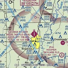
| Sectional chart |
|---|
|
| Airport distance calculator |
|---|
|
|
| Sunrise and sunset |
|---|
|
Times for 01-Jul-2026
| | Local
(UTC-5) | | Zulu
(UTC) |
|---|
| Morning civil twilight | | 05:33 | | 10:33 |
| Sunrise | | 06:01 | | 11:01 |
| Sunset | | 20:06 | | 01:06 |
| Evening civil twilight | | 20:33 | | 01:33 |
|
| Current date and time |
|---|
| Zulu (UTC) | 02-Jul-2026 03:39:40 |
|---|
| Local (UTC-5) | 01-Jul-2026 22:39:40 |
|---|
|
| METAR |
|---|
| KBXA | 020315Z AUTO 00000KT 10SM CLR 26/24 A3005 RMK AO2 T02550236
|
|
| TAF |
|---|
KHDC
34nm SW | 011731Z 0118/0218 05007KT P6SM SCT040 PROB30 0118/0124 4SM -TSRA BKN030CB FM020100 00000KT P6SM FEW045 SCT250
|
KASD
34nm S | 011731Z 0118/0218 07007KT P6SM SKC PROB30 0118/0123 4SM -TSRA BKN030CB FM021500 08005KT P6SM SCT250
|
|
| NOTAMs |
|---|
NOTAMs are issued by the DoD/FAA and will open in a separate window not controlled by AirNav.
|
|

