FAA INFORMATION EFFECTIVE 09 JULY 2026
Location
| FAA Identifier: | CDR |
| Lat/Long: | 42-50-15.2077N 103-05-43.4469W
42-50.253462N 103-05.724115W
42.8375577,-103.0954019
(estimated) |
| Elevation: | 3297.8 ft. / 1005.2 m (surveyed) |
| Variation: | 07E (2020) |
| From city: | 4 miles W of CHADRON, NE |
| Time zone: | UTC -6 (UTC -7 during Standard Time) |
| Zip code: | 69337 |
Airport Operations
| Airport use: | Open to the public |
| Activation date: | 04/1940 |
| Control tower: | no |
| ARTCC: | DENVER CENTER |
| FSS: | COLUMBUS FLIGHT SERVICE STATION |
| NOTAMs facility: | CDR (NOTAM-D service available) |
| Attendance: | 0800-1600 |
| Wind indicator: | lighted |
| Segmented circle: | yes |
| Lights: | ACTVT HIRL RY 03/21 & MIRL RY 12/30; REIL RY 21 & RY 30 ; PAPI RYS 12/30; VASI RYS 03/21; MALSR RY 03 - CTAF. |
| Beacon: | white-green (lighted land airport)
Operates sunset to sunrise. |
Airport Communications
| CTAF/UNICOM: | 122.8 |
| WX ASOS: | 118.05 (308-880-5992) |
- APCH/DEP CTL SVC PRVDD BY DENVER ARTCC (ZDV) ON FREQS 127.95/338.2 (CRAWFORD RCAG).
Nearby radio navigation aids
| VOR radial/distance | | VOR name | | Freq | | Var |
|---|
| TSTr017/19.3 | | TOADSTOOL VOR/DME | | 113.40 | | 13E |
| NDB name | | Hdg/Dist | | Freq | | Var | | ID |
|---|
| WHITNEY | | at field | | 275 | | 07E | | HIN | .... .. -. |
| DAWES | | 028/6.1 | | 362 | | 07E | | CD | -.-. -.. |
Airport Services
| Fuel available: | 100LL JET-A |
| Parking: | hangars and tiedowns |
| Airframe service: | MAJOR |
| Powerplant service: | MAJOR |
Runway Information
Runway 3/21
| Dimensions: | 5998 x 100 ft. / 1828 x 30 m |
| Surface: | concrete, in excellent condition |
| Weight bearing capacity: | | PCN 12 /R/B/W/T | | Single wheel: | 30.0 | | Double wheel: | 55.0 | | Double tandem: | 90.0 |
|
| Runway edge lights: | high intensity |
| RUNWAY 3 | | RUNWAY 21 |
| Latitude: | 42-49.979082N | | 42-50.786902N |
| Longitude: | 103-06.019768W | | 103-05.248553W |
| Elevation: | 3297.8 ft. | | 3268.7 ft. |
| Traffic pattern: | left | | left |
| Runway heading: | 028 magnetic, 035 true | | 208 magnetic, 215 true |
| Displaced threshold: | 289 ft. | | 498 ft. |
| Declared distances: | TORA:5998 TODA:5998 ASDA:5500 LDA:5211 | | TORA:5998 TODA:5998 ASDA:5500 LDA:5500 |
| Markings: | precision, in good condition | | nonprecision, in good condition |
| Visual slope indicator: | 4-box VASI on left (3.00 degrees glide path) | | 4-box VASI on left (3.00 degrees glide path) |
| Approach lights: | MALSR: 1,400 foot medium intensity approach lighting system with runway alignment indicator lights | | |
| Runway end identifier lights: | no | | yes |
| Touchdown point: | yes, no lights | | yes, no lights |
| Instrument approach: | ILS | | |
| Obstructions: | none
APCH RATIO 45:1 FM DSPLCD THR. | | 14 ft. brush, 331 ft. from runway, 426 ft. left of centerline, 9:1 slope to clear |
Runway 12/30
| Dimensions: | 4400 x 75 ft. / 1341 x 23 m |
| Surface: | concrete, in excellent condition |
| Weight bearing capacity: | | PCN 10 /R/B/W/T | | Single wheel: | 21.0 | | Double wheel: | 30.0 |
|
| Runway edge lights: | medium intensity |
| RUNWAY 12 | | RUNWAY 30 |
| Latitude: | 42-50.284243N | | 42-49.869533N |
| Longitude: | 103-06.250037W | | 103-05.443443W |
| Elevation: | 3293.7 ft. | | 3283.7 ft. |
| Traffic pattern: | left | | left |
| Runway heading: | 118 magnetic, 125 true | | 298 magnetic, 305 true |
| Declared distances: | TORA:4400 TODA:4400 ASDA:4400 LDA:4400 | | TORA:4400 TODA:4400 ASDA:4400 LDA:4400 |
| Markings: | nonprecision, in good condition | | nonprecision, in good condition |
| Visual slope indicator: | 4-light PAPI on left (3.00 degrees glide path) | | 4-light PAPI on left (3.00 degrees glide path) |
| Runway end identifier lights: | | | yes |
| Touchdown point: | yes, no lights | | yes, no lights |
| Obstructions: | 15 ft. trees, 936 ft. from runway, 169 ft. right of centerline, 49:1 slope to clear | | 35 ft. road, 1400 ft. from runway, 220 ft. left of centerline, 34:1 slope to clear |
Airport Ownership and Management from official FAA records
| Ownership: | Publicly-owned |
| Owner: | CITY OF CHADRON
P.O. BOX 390
CHADRON, NE 69337-0390
Phone 308-432-0505 |
| Manager: | MR. TOM MENKE
P.O. BOX 390
CHADRON, NE 69337-0390
Phone 308-432-0505
ROGER STEVENS ON SITE AIRPORT OPERATIONS SUPERVISOR. ARPT OFFICE 308-615-9007 |
Additional Remarks
| - | FOR CD IF UNA TO CTC ON FSS FREQ, CTC DENVER ARTCC AT 303-651-4257. |
Instrument Procedures
NOTE: All procedures below are presented as PDF files. If you need a reader for these files, you should download the free Adobe Reader.NOT FOR NAVIGATION. Please procure official charts for flight.
FAA instrument procedures published for use from 09 July 2026 at 0901Z to 06 August 2026 at 0900Z.
IAPs - Instrument Approach Procedures |
|---|
| ILS OR LOC RWY 03 **CHANGED** | |
download (255KB) |
| RNAV (GPS) RWY 03 **CHANGED** | |
download (316KB) |
| RNAV (GPS) RWY 12 **CHANGED** | |
download (247KB) |
| RNAV (GPS) RWY 21 **CHANGED** | |
download (253KB) |
| RNAV (GPS) RWY 30 **CHANGED** | |
download (252KB) |
| NDB RWY 21 **CHANGED** | |
download (182KB) |
| NOTE: Special Alternate Minimums apply **CHANGED** | |
download (146KB) |
| NOTE: Special Take-Off Minimums/Departure Procedures apply | |
download (196KB) |
Other nearby airports with instrument procedures:
KIEN - Pine Ridge Airport (28 nm NE)
9V5 - Modisett Airport (29 nm E)
KHSR - Hot Springs Municipal Airport (34 nm N)
KGRN - Gordon Municipal Airport (41 nm E)
KAIA - Alliance Municipal Airport (49 nm S)
|
|

Road maps at:
MapQuest
Bing
Google
| Aerial photo |
|---|
WARNING: Photo may not be current or correct

Do you have a better or more recent aerial photo of Chadron Municipal Airport that you would like to share? If so, please send us your photo.
|
| Sectional chart |
|---|
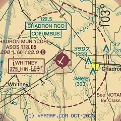
|
| Airport distance calculator |
|---|
|
|
| Sunrise and sunset |
|---|
|
Times for 27-Jul-2026
| | Local
(UTC-6) | | Zulu
(UTC) |
|---|
| Morning civil twilight | | 05:07 | | 11:07 |
| Sunrise | | 05:40 | | 11:40 |
| Sunset | | 20:18 | | 02:18 |
| Evening civil twilight | | 20:51 | | 02:51 |
|
| Current date and time |
|---|
| Zulu (UTC) | 27-Jul-2026 21:30:29 |
|---|
| Local (UTC-6) | 27-Jul-2026 15:30:29 |
|---|
|
| METAR |
|---|
| KCDR | 272053Z AUTO 16023G32KT 10SM FEW120 38/12 A2992 RMK AO2 PK WND 15032/2046 LTG DSNT NW-NE SLP095 T03780122 58009
|
|
| TAF |
|---|
| KCDR | 271740Z 2718/2818 29010KT P6SM FEW120 FM271900 17012G20KT P6SM BKN120 PROB30 2722/2802 VRB35G45KT 6SM -TSRA OVC080CB FM280200 07011KT P6SM VCSH OVC100 FM281000 VRB05KT P6SM SCT150
|
|
| NOTAMs |
|---|
NOTAMs are issued by the DoD/FAA and will open in a separate window not controlled by AirNav.
|
|

