FAA INFORMATION EFFECTIVE 19 FEBRUARY 2026
Location
| FAA Identifier: | CNU |
| Lat/Long: | 37-40-04.3820N 095-29-12.1760W
37-40.073033N 095-29.202933W
37.6678839,-95.4867156
(estimated) |
| Elevation: | 1002.5 ft. / 305.6 m (surveyed) |
| Variation: | 01E (2030) |
| From city: | 2 miles SW of CHANUTE, KS |
| Time zone: | UTC -6 (UTC -5 during Daylight Saving Time) |
| Zip code: | 66720 |
Airport Operations
| Airport use: | Open to the public |
| Activation date: | 04/1940 |
| Control tower: | no |
| ARTCC: | KANSAS CITY CENTER |
| FSS: | WICHITA FLIGHT SERVICE STATION |
| NOTAMs facility: | CNU (NOTAM-D service available) |
| Attendance: | SUN 1200-1700, ALL MON-SAT 0800-1700
FOR AFT HRS EMERG CALL (620) 305-9689. |
| Wind indicator: | lighted |
| Segmented circle: | yes |
| Lights: | ACTVT REIL RWY 18 & 36; PAPI RWY 18 & 36; MIRL RWY 18/36 - CTAF. |
| Beacon: | white-green (lighted land airport)
DUSK-2300 |
Airport Communications
| CTAF/UNICOM: | 122.7 |
| WX ASOS: | 127.075 (620-431-6781) |
| WX AWOS-3PT at K88 (13 nm N): | 128.325 (620-365-1466) |
- APCH/DEP CTL SVC PRVDD BY KANSAS CITY ARTCC (ZKC) ON FREQS 132.9/279.5 (CHANUTE RCAG).
Airport Services
| Fuel available: | 100LL JET-A |
| Parking: | hangars and tiedowns |
| Airframe service: | NONE |
| Powerplant service: | NONE |
| Bottled oxygen: | NONE |
| Bulk oxygen: | NONE |
Runway Information
Runway 18/36
| Dimensions: | 4254 x 75 ft. / 1297 x 23 m |
| Surface: | asphalt, in good condition |
| Weight bearing capacity: | | PCN 5 /F/C/Y/U | | Single wheel: | 12.0 |
|
| Runway edge lights: | medium intensity |
| RUNWAY 18 | | RUNWAY 36 |
| Latitude: | 37-40.421123N | | 37-39.724942N |
| Longitude: | 095-29.151992W | | 095-29.253862W |
| Elevation: | 982.1 ft. | | 1002.5 ft. |
| Traffic pattern: | left | | left |
| Runway heading: | 186 magnetic, 187 true | | 006 magnetic, 007 true |
| Displaced threshold: | no | | 269 ft. |
| Markings: | nonprecision, in fair condition | | nonprecision, in fair condition |
| Visual slope indicator: | 2-light PAPI on left (3.00 degrees glide path) | | 2-light PAPI on left (3.00 degrees glide path) |
| Runway end identifier lights: | yes | | yes |
| Touchdown point: | yes, no lights | | yes, no lights |
| Obstructions: | 48 ft. tree, 693 ft. from runway, 190 ft. left of centerline, 10:1 slope to clear
+25 FT TREE 173 FRM AER 18, 190 FT L OF CL. | | 23 ft. rr, 270 ft. from runway, 3:1 slope to clear
APCH RATIO 32:1 FROM DSPLCD THR. |
Airport Ownership and Management from official FAA records
| Ownership: | Publicly-owned |
| Owner: | CITY OF CHANUTE
MEMORIAL BLDG
CHANUTE, KS 66720
Phone 620-431-5296 |
| Manager: | RYAN FOLMER
800 S. COUNTRY CLUB ROAD
CHANUTE, KS 66720
Phone 620-305-9689 |
Additional Remarks
| - | ULTRALIGHT ACTV, BIRDS & WILDLIFE ON & INVOF ARPT. |
| - | COURTSEY CAR AVBL. |
| - | FOR CD IF UNA TO CTC ON FSS FREQ, CTC KANSAS CITY ARTCC AT 913-254-8508. |
Instrument Procedures
NOTE: All procedures below are presented as PDF files. If you need a reader for these files, you should download the free Adobe Reader.NOT FOR NAVIGATION. Please procure official charts for flight.
FAA instrument procedures published for use from 19 February 2026 at 0901Z to 19 March 2026 at 0900Z.
IAPs - Instrument Approach Procedures |
|---|
| RNAV (GPS) RWY 36 | |
download (167KB) |
| NOTE: Special Alternate Minimums apply | |
download (146KB) |
| NOTE: Special Take-Off Minimums/Departure Procedures apply | |
download (353KB) |
Other nearby airports with instrument procedures:
K88 - Allen County Airport (13 nm N)
2K7 - Neodesha Municipal Airport (16 nm SW)
KPPF - Tri-City Airport (20 nm S)
KIDP - Independence Municipal Airport (34 nm SW)
KCFV - Coffeyville Municipal Airport (35 nm S)
|
|

Road maps at:
MapQuest
Bing
Google
| Aerial photo |
|---|
WARNING: Photo may not be current or correct

Do you have a better or more recent aerial photo of Chanute Martin Johnson Airport that you would like to share? If so, please send us your photo.
|
| Sectional chart |
|---|
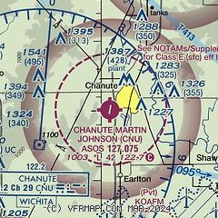
|
| Airport distance calculator |
|---|
|
|
| Sunrise and sunset |
|---|
|
Times for 20-Feb-2026
| | Local
(UTC-6) | | Zulu
(UTC) |
|---|
| Morning civil twilight | | 06:40 | | 12:40 |
| Sunrise | | 07:06 | | 13:06 |
| Sunset | | 18:05 | | 00:05 |
| Evening civil twilight | | 18:32 | | 00:32 |
|
| Current date and time |
|---|
| Zulu (UTC) | 20-Feb-2026 10:57:32 |
|---|
| Local (UTC-6) | 20-Feb-2026 04:57:32 |
|---|
|
| METAR |
|---|
| KCNU | 201052Z AUTO 26006KT 10SM CLR M07/M10 A2995 RMK AO2 SLP148 T10671100
|
KK88
13nm N | 201035Z AUTO 30007G14KT 10SM CLR M06/M09 A2991 RMK AO2
|
|
| TAF |
|---|
| KCNU | 200520Z 2006/2106 31014G20KT P6SM SKC FM201100 32008KT P6SM SKC FM202300 04007KT P6SM OVC090
|
|
| NOTAMs |
|---|
NOTAMs are issued by the DoD/FAA and will open in a separate window not controlled by AirNav.
|
|

