FAA INFORMATION EFFECTIVE 11 JUNE 2026
Location
| FAA Identifier: | DMO |
| Lat/Long: | 38-42-26.7000N 093-10-33.3000W
38-42.445000N 093-10.555000W
38.7074167,-93.1759167
(estimated) |
| Elevation: | 909.7 ft. / 277.3 m (surveyed) |
| Variation: | 03E (2000) |
| From city: | 2 miles E of SEDALIA, MO |
| Time zone: | UTC -5 (UTC -6 during Standard Time) |
| Zip code: | 65301 |
Airport Operations
| Airport use: | Open to the public |
| Activation date: | 10/1952 |
| Control tower: | no |
| ARTCC: | KANSAS CITY CENTER |
| FSS: | COLUMBIA FLIGHT SERVICE STATION |
| NOTAMs facility: | DMO (NOTAM-D service available) |
| Attendance: | MON-FRI 0700-1800, ALL SAT-SUN 0800-1800 |
| Wind indicator: | lighted |
| Segmented circle: | yes |
| Lights: | ACTVT REIL RWY 18 & 36; MIRL RWY 18/36 & 05/23 - CTAF. PAPI RWY 18 & 36 ON 24 HRS. |
| Beacon: | white-green (lighted land airport)
Operates sunset to sunrise. |
Airport Communications
| CTAF/UNICOM: | 122.8 |
| WX ASOS: | 120.525 (660-826-8225) |
| WHITEMAN APPROACH: | 127.45 |
| WHITEMAN DEPARTURE: | 125.925 |
- APCH/DEP SVC PRVDD BY KANSAS CITY ARTCC ON FREQS 135.575/323.15 (KNOB NOSTER RCAG) WHEN WHITEMAN APCH CTL CLSD.
Airport Services
| Fuel available: | 100LL JET-A |
| Parking: | tiedowns |
| Airframe service: | MAJOR |
| Powerplant service: | MAJOR |
| Bottled oxygen: | NONE |
| Bulk oxygen: | HIGH/LOW |
Runway Information
Runway 18/36
| Dimensions: | 5500 x 100 ft. / 1676 x 30 m |
| Surface: | concrete, in excellent condition |
| Weight bearing capacity: | | PCN 17 /R/C/W/T | | Single wheel: | 50.0 | | Double wheel: | 65.0 |
|
| Runway edge lights: | medium intensity |
| RUNWAY 18 | | RUNWAY 36 |
| Latitude: | 38-43.009825N | | 38-42.104172N |
| Longitude: | 093-10.342647W | | 093-10.376710W |
| Elevation: | 882.1 ft. | | 900.4 ft. |
| Traffic pattern: | left | | right |
| Runway heading: | 179 magnetic, 182 true | | 359 magnetic, 002 true |
| Markings: | nonprecision, in good condition | | nonprecision, in good condition |
| Visual slope indicator: | 4-light PAPI on left (3.00 degrees glide path) | | 4-light PAPI on left (3.00 degrees glide path) |
| Runway end identifier lights: | yes | | yes |
| Touchdown point: | yes, no lights | | yes, no lights |
Runway 5/23
| Dimensions: | 3519 x 50 ft. / 1073 x 15 m |
| Surface: | asphalt, in fair condition |
| Weight bearing capacity: | | PCN 7 /F/D/X/T | | Single wheel: | 19.0 |
|
| Runway edge lights: | medium intensity |
| RUNWAY 5 | | RUNWAY 23 |
| Latitude: | 38-42.100228N | | 38-42.437197N |
| Longitude: | 093-11.159675W | | 093-10.557630W |
| Elevation: | 909.5 ft. | | 884.3 ft. |
| Traffic pattern: | left | | right |
| Runway heading: | 051 magnetic, 054 true | | 231 magnetic, 234 true |
| Markings: | basic, in good condition | | basic, in good condition |
| Touchdown point: | yes, no lights | | yes, no lights |
| Obstructions: | 54 ft. tree, 615 ft. from runway, 270 ft. left of centerline, 7:1 slope to clear | | 15 ft. brush, 243 ft. from runway, 125 ft. left of centerline, 2:1 slope to clear
BRUSH 5-6 FT TALL 130-200 FT FM THR 130 FT RIGHT. |
Airport Ownership and Management from official FAA records
| Ownership: | Publicly-owned |
| Owner: | CITY OF SEDALIA
200 S. OSAGE
SEDALIA, MO 65301
Phone 660-827-3000 |
| Manager: | MITCHELL MULLEN
1900 E BOONEVILLE
SEDALIA, MO 65301
Phone 660-826-4128 |
Additional Remarks
| A105 | ARMY NATIONAL GUARD TRAINING. |
| - | WILDLIFE ON RYS EARLY MORNING & DUSK. |
| - | 100LL SELF SERVICE AVBL 24/7 |
| - | JET A AVBL AFTER HOURS - $80 FEE - CALL 660-826-8100 |
| - | FOR CD IF UNA TO CTC ON FSS FREQ, CTC WHITEMAN APCH AT 660-687-3132. WHEN WHITEMAN APCH IS CLSD, CTC KANSAS CITY ARTCC AT 913-254-8508. |
Instrument Procedures
NOTE: All procedures below are presented as PDF files. If you need a reader for these files, you should download the free Adobe Reader.NOT FOR NAVIGATION. Please procure official charts for flight.
FAA instrument procedures published for use from 11 June 2026 at 0901Z to 09 July 2026 at 0900z.
IAPs - Instrument Approach Procedures |
|---|
| RNAV (GPS) RWY 18 | |
download (219KB) |
| RNAV (GPS) RWY 36 | |
download (236KB) |
| NOTE: Special Alternate Minimums apply | |
download (40KB) |
| NOTE: Special Take-Off Minimums/Departure Procedures apply | |
download (166KB) |
Other nearby airports with instrument procedures:
KSZL - Whiteman Air Force Base (17 nm W)
KRAW - Warsaw Municipal Airport (23 nm S)
KMHL - Marshall Memorial Municipal Airport (23 nm N)
KVER - Jesse Viertel Memorial Airport (27 nm NE)
KRCM - Skyhaven Airport (30 nm W)
|
|

Road maps at:
MapQuest
Bing
Google
| Aerial photo |
|---|
WARNING: Photo may not be current or correct
 Photo taken 12-Jul-2010
looking south.
Photo taken 12-Jul-2010
looking south.
Do you have a better or more recent aerial photo of Sedalia Regional Airport that you would like to share? If so, please send us your photo.
|
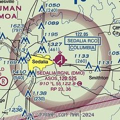
| Sectional chart |
|---|
|
| Airport distance calculator |
|---|
|
|
| Sunrise and sunset |
|---|
|
Times for 28-Jun-2026
| | Local
(UTC-5) | | Zulu
(UTC) |
|---|
| Morning civil twilight | | 05:19 | | 10:19 |
| Sunrise | | 05:51 | | 10:51 |
| Sunset | | 20:41 | | 01:41 |
| Evening civil twilight | | 21:12 | | 02:12 |
|
| Current date and time |
|---|
| Zulu (UTC) | 28-Jun-2026 10:10:11 |
|---|
| Local (UTC-5) | 28-Jun-2026 05:10:11 |
|---|
|
| METAR |
|---|
KSZL
17nm W | 280855Z AUTO 16007KT 10SM CLR 25/23 A2979 RMK AO2 LTG DSNT NE SLP081 T02530233 57005
|
|
| TAF |
|---|
KSZL
17nm W | 271900Z 2719/2901 18009KT 9999 BKN025 QNH2985INS BECMG 2804/2805 18009KT 9999 FEW060 QNH2983INS BECMG 2807/2808 18009KT 9999 SKC WS020/21035KT QNH2980INS BECMG 2813/2814 18010G20KT 9999 SKC QNH2984INS BECMG 2817/2818 20015G25KT 9999 SCT050 510004 QNH2977INS BECMG 2900/2901 20012KT 9999 FEW060 QNH2978INS TX33/2819Z TN24/2812Z LAST NO AMDS AFT 2721 NEXT 2911
|
|
| NOTAMs |
|---|
NOTAMs are issued by the DoD/FAA and will open in a separate window not controlled by AirNav.
|
|

