FAA INFORMATION EFFECTIVE 11 JUNE 2026
Location
| FAA Identifier: | DUG |
| Lat/Long: | 31-28-08.2000N 109-36-13.5000W
31-28.136667N 109-36.225000W
31.4689444,-109.6037500
(estimated) |
| Elevation: | 4150.2 ft. / 1265.0 m (surveyed) |
| Variation: | 12E (1980) |
| From city: | 8 miles NW of DOUGLAS BISBEE, AZ |
| Time zone: | UTC -7 (year round; does not observe DST) |
| Zip code: | 85607 |
Airport Operations
| Airport use: | Open to the public |
| Activation date: | 09/1942 |
| Control tower: | no |
| ARTCC: | ALBUQUERQUE CENTER |
| FSS: | PRESCOTT FLIGHT SERVICE STATION |
| NOTAMs facility: | DUG (NOTAM-D service available) |
| Attendance: | MON-FRI 0700-1500 |
| Wind indicator: | lighted |
| Segmented circle: | yes |
| Lights: | ACTVT VASI RWY 17; MIRL RWY 17/35 - CTAF. |
| Beacon: | white-green (lighted land airport)
Operates sunset to sunrise. |
| International operations: | international airport of entry |
Airport Communications
| CTAF/UNICOM: | 123.0 |
| WX ASOS: | 119.275 (520-364-7208) |
| WX AWOS-2 at P03 (7 nm SW): | 119.925 (520-417-4114) |
- COMMUNICATIONS PRVDD BY PRESCOTT RADIO ON FREQ 122.6 (DOUGLAS RCO).
- APCH/DEP SVC PRVDD BY ALBUQUERQUE ARTCC (ABQ) ON 134.45/327.15 (SILVER CITY RCAG & 133.0/281.5 TUCSON RCAG).
Nearby radio navigation aids
| VOR radial/distance | | VOR name | | Freq | | Var |
|---|
| DUG at field | | DOUGLAS VORTAC | | 108.80 | | 13E |
| FHUr088/39.1 | | LIBBY VOR/DME | | 113.60 | | 13E |
Airport Services
| Fuel available: | 100LL JET-A1+
100LL:SELF SVC - AMGR. |
| Parking: | tiedowns |
Runway Information
Runway 17/35
| Dimensions: | 6430 x 100 ft. / 1960 x 30 m |
| Surface: | asphalt/rubberized friction seal coat, in good condition
RFSC 100 FT WIDE. |
| Weight bearing capacity: | | Single wheel: | 30.0 | | Double wheel: | 160.0 | | Double tandem: | 250.0 |
|
| Runway edge lights: | medium intensity |
| RUNWAY 17 | | RUNWAY 35 |
| Latitude: | 31-28.430585N | | 31-27.370300N |
| Longitude: | 109-36.269198W | | 109-36.264912W |
| Elevation: | 4124.5 ft. | | 4088.9 ft. |
| Traffic pattern: | left | | left |
| Runway heading: | 168 magnetic, 180 true | | 348 magnetic, 360 true |
| Markings: | nonprecision, in fair condition | | nonprecision, in fair condition |
| Visual slope indicator: | 2-box VASI on left (3.25 degrees glide path) | | |
| Runway end identifier lights: | no | | no |
| Touchdown point: | yes, no lights | | yes, no lights |
Runway 8/26
| Dimensions: | 4966 x 60 ft. / 1514 x 18 m |
| Surface: | asphalt, in fair condition |
| Weight bearing capacity: | |
| Operational restrictions: | DALGT VFR OPS ONLY. |
| RUNWAY 8 | | RUNWAY 26 |
| Latitude: | 31-28.444142N | | 31-28.441600N |
| Longitude: | 109-36.646697W | | 109-35.691178W |
| Elevation: | 4115.6 ft. | | 4150.0 ft. |
| Traffic pattern: | left | | left |
| Runway heading: | 078 magnetic, 090 true | | 258 magnetic, 270 true |
| Markings: | basic, in fair condition | | basic, in fair condition |
| Touchdown point: | yes, no lights | | yes, no lights |
| Obstructions: | 8 ft. brush, 264 ft. from runway, 44 ft. right of centerline, 8:1 slope to clear
3- 10 FT BRUSH 0-200 FT FM THR 40-125 FT R OF CNTRLN. | | 5 ft. brush, 201 ft. from runway, 70 ft. left of centerline
4-6 FT BRUSH 20-200 FT FM THR 75 FT BOTH SIDES OF CNTRLN. |
Airport Ownership and Management from official FAA records
| Ownership: | Publicly-owned |
| Owner: | COCHISE COUNTY
1415 W. MELODY LANE BLDG F
BISBEE, AZ 85603
Phone 520-432-9268 |
| Manager: | DARRELL CROWLEY
1415 W. MELODY LANE BLDG F
BISBEE, AZ 85603
Phone 520-432-9742
EMERG - 520-559-8708. |
Additional Remarks
| - | WILDLIFE ON OR INVOF ARPT. |
| - | FOR CD IF UNA TO CTC ON FSS FREQ, CTC ALBUQUERQUE ARTCC AT 505-856-4561. |
| A58-17 | 20 FT ACFT TAIL HEIGHT RWY 08/26 AT 55 FT TO CNTRLN; APCH SLOPE 04:1 AT THR. |
Instrument Procedures
NOTE: All procedures below are presented as PDF files. If you need a reader for these files, you should download the free Adobe Reader.NOT FOR NAVIGATION. Please procure official charts for flight.
FAA instrument procedures published for use from 11 June 2026 at 0901Z to 09 July 2026 at 0900z.
IAPs - Instrument Approach Procedures |
|---|
| RNAV (GPS) RWY 17 | |
download (204KB) |
| VOR/DME RWY 17 | |
download (226KB) |
| VOR RWY 17 | |
download (166KB) |
| NOTE: Special Alternate Minimums apply | |
download (119KB) |
| NOTE: Special Take-Off Minimums/Departure Procedures apply | |
download (113KB) |
Other nearby airports with instrument procedures:
KFHU - Sierra Vista Municipal Airport-Libby Army Airfield (39 nm W)
P33 - Cochise County Airport (49 nm N)
KOLS - Nogales International Airport (64 nm W)
KDMA - Davis Monthan Air Force Base (77 nm NW)
KTUS - Tucson International Airport (79 nm NW)
|
|

Road maps at:
MapQuest
Bing
Google
| Aerial photo |
|---|
WARNING: Photo may not be current or correct

Do you have a better or more recent aerial photo of Bisbee Douglas International Airport that you would like to share? If so, please send us your photo.
|
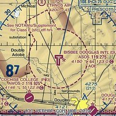
| Sectional chart |
|---|
|
CAUTION: Diagram may not be current

| Airport distance calculator |
|---|
|
|
| Sunrise and sunset |
|---|
|
Times for 27-Jun-2026
| | Local
(UTC-7) | | Zulu
(UTC) |
|---|
| Morning civil twilight | | 04:49 | | 11:49 |
| Sunrise | | 05:17 | | 12:17 |
| Sunset | | 19:26 | | 02:26 |
| Evening civil twilight | | 19:54 | | 02:54 |
|
| Current date and time |
|---|
| Zulu (UTC) | 27-Jun-2026 22:58:48 |
|---|
| Local (UTC-7) | 27-Jun-2026 15:58:48 |
|---|
|
| METAR |
|---|
| KDUG | 272156Z AUTO 26018G30KT 10SM CLR 37/07 A3001 RMK AO2 PK WND 25030/2152 SLP075 T03670067 TSNO
|
|
| TAF |
|---|
| KDUG | 271720Z 2718/2818 24011G19KT P6SM SCT120 SCT200 FM272000 25018G28KT P6SM SCT120 BKN200 FM280300 25010KT P6SM SCT120 FM280700 20007KT P6SM FEW120
|
|
| NOTAMs |
|---|
NOTAMs are issued by the DoD/FAA and will open in a separate window not controlled by AirNav.
|
|


