FAA INFORMATION EFFECTIVE 09 JULY 2026
Location
| FAA Identifier: | EED |
| Lat/Long: | 34-45-58.8486N 114-37-23.8076W
34-45.980810N 114-37.396793W
34.7663468,-114.6232799
(estimated) |
| Elevation: | 983.1 ft. / 299.6 m (surveyed) |
| Variation: | 14E (1980) |
| From city: | 5 miles S of NEEDLES, CA |
| Time zone: | UTC -7 (UTC -8 during Standard Time) |
| Zip code: | 92363 |
Airport Operations
| Airport use: | Open to the public |
| Activation date: | 05/1941 |
| Control tower: | no |
| ARTCC: | LOS ANGELES CENTER |
| FSS: | RIVERSIDE FLIGHT SERVICE STATION |
| NOTAMs facility: | EED (NOTAM-D service available) |
| Attendance: | UNATNDD |
| Wind indicator: | lighted |
| Segmented circle: | yes |
| Lights: | ACTVT MIRL RY 11/29 & RY 02/20, REIL RY 11& RY 29 - CTAF. PAPI RY 11, RY 29, RY 02 & RY 20 OPER CONTINUOUSLY. |
| Beacon: | white-green (lighted land airport)
Operates sunset to sunrise. |
| Taxiway lights: | 2 LGTS EACH SIDE MARKING RWY EXITS; REFLECTORS MARKING TWYS. |
Airport Communications
| CTAF/UNICOM: | 123.0 |
| WX ASOS: | 128.325 (760-326-4281) |
| WX AWOS-3 at HII (18 nm SE): | 119.025 (928-764-2309) |
- APCH/DEP CTL SVC PRVDD BY LOS ANGELES ARTCC (ZLA) ON FREQUENCIES 134.65/360.65 (NELSON RCAG).
Nearby radio navigation aids
| VOR radial/distance | | VOR name | | Freq | | Var |
|---|
| EEDr255/7.4 | | NEEDLES VORTAC | | 115.20 | | 15E |
| GFSr114/34.9 | | GOFFS VORTAC | | 114.40 | | 15E |
| PKEr349/40.0 | | PARKER VORTAC | | 117.90 | | 15E |
Airport Services
| Fuel available: | 100LL JET-A
A:JET A FUEL AVBL 24 HRS SELF SVC
100LL:100LL FUEL AVBL 24 HRS SELF SRV |
| Parking: | tiedowns |
| Airframe service: | MINOR |
| Powerplant service: | MINOR |
| Bottled oxygen: | NONE |
| Bulk oxygen: | NONE |
Runway Information
Runway 11/29
| Dimensions: | 5005 x 100 ft. / 1526 x 30 m |
| Surface: | asphalt, in poor condition
CRACKS IN PAVEMENT |
| Weight bearing capacity: | | Single wheel: | 16.0 | | Double wheel: | 32.0 |
|
| Runway edge lights: | medium intensity |
| Runway edge markings: | NSTD MARKINGS FOR INSTR APCH; BSC INSTEAD OF NPI MARKINGS. |
| RUNWAY 11 | | RUNWAY 29 |
| Latitude: | 34-46.023500N | | 34-45.622267N |
| Longitude: | 114-38.018567W | | 114-37.145083W |
| Elevation: | 983.1 ft. | | 918.5 ft. |
| Traffic pattern: | left | | left |
| Runway heading: | 105 magnetic, 119 true | | 285 magnetic, 299 true |
| Markings: | basic, in fair condition | | basic, in fair condition |
| Visual slope indicator: | 2-light PAPI on left (3.00 degrees glide path) | | 2-light PAPI on left (3.00 degrees glide path) |
| Runway end identifier lights: | yes | | yes |
| Touchdown point: | yes, no lights | | yes, no lights |
Runway 2/20
| Dimensions: | 4235 x 100 ft. / 1291 x 30 m |
| Surface: | asphalt, in poor condition
CRACKS IN PAVEMENT. |
| Weight bearing capacity: | | Single wheel: | 16.0 | | Double wheel: | 32.0 |
|
| Runway edge lights: | medium intensity |
| RUNWAY 2 | | RUNWAY 20 |
| Latitude: | 34-45.862500N | | 34-46.472400N |
| Longitude: | 114-37.384167W | | 114-36.972083W |
| Elevation: | 929.4 ft. | | 843.9 ft. |
| Traffic pattern: | left | | left |
| Runway heading: | 015 magnetic, 029 true | | 195 magnetic, 209 true |
| Markings: | nonprecision, in fair condition | | nonprecision, in fair condition |
| Visual slope indicator: | 2-light PAPI on left (3.00 degrees glide path) | | 2-light PAPI on left (3.00 degrees glide path) |
| Touchdown point: | yes, no lights | | yes, no lights |
Airport Ownership and Management from official FAA records
| Ownership: | Publicly-owned |
| Owner: | CO OF SAN BERNARDINO
268 HOSPITALITY LANE, SUITE 302
SAN BERNARDINO, CA 92415
Phone 909-387-7810 |
| Manager: | TESS COOK
711 AIRPORT RD
NEEDLES, CA 92363
Phone 909-327-8740 |
Additional Remarks
| - | UNLGTD MTN WEST & SOUTH OF ARPT APRX 3200' MSL. |
| - | FOR CD IF UNA TO CTC ON FSS FREQ, CTC LOS ANGELES ARTCC AT 661-575-2079. |
Instrument Procedures
NOTE: All procedures below are presented as PDF files. If you need a reader for these files, you should download the free Adobe Reader.NOT FOR NAVIGATION. Please procure official charts for flight.
FAA instrument procedures published for use from 09 July 2026 at 0901Z to 06 August 2026 at 0900Z.
IAPs - Instrument Approach Procedures |
|---|
| RNAV (GPS) RWY 29 | |
download (283KB) |
| VOR-A | |
download (262KB) |
| NOTE: Special Alternate Minimums apply | |
download (118KB) |
| NOTE: Special Take-Off Minimums/Departure Procedures apply | |
download (134KB) |
Other nearby airports with instrument procedures:
KHII - Lake Havasu City Airport (18 nm SE)
KIFP - Laughlin/Bullhead International Airport (24 nm N)
P20 - Avi Suquilla Airport (41 nm SE)
KIGM - Kingman Airport (45 nm NE)
KBLH - Blythe Airport (69 nm S)
|
|

Road maps at:
MapQuest
Bing
Google
| Aerial photo |
|---|
WARNING: Photo may not be current or correct

Do you have a better or more recent aerial photo of Needles Airport that you would like to share? If so, please send us your photo.
|
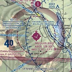
| Sectional chart |
|---|
|
| Airport distance calculator |
|---|
|
|
| Sunrise and sunset |
|---|
|
Times for 16-Jul-2026
| | Local
(UTC-7) | | Zulu
(UTC) |
|---|
| Morning civil twilight | | 05:09 | | 12:09 |
| Sunrise | | 05:38 | | 12:38 |
| Sunset | | 19:51 | | 02:51 |
| Evening civil twilight | | 20:20 | | 03:20 |
|
| Current date and time |
|---|
| Zulu (UTC) | 17-Jul-2026 05:28:29 |
|---|
| Local (UTC-7) | 16-Jul-2026 22:28:29 |
|---|
|
| METAR |
|---|
| KEED | 170456Z AUTO 19008KT 10SM CLR 35/18 A2979 RMK AO2 SLP048 T03500178
|
KHII
18nm SE | 170515Z AUTO 13010KT 10SM CLR 35/17 A2979 RMK AO2
|
|
| TAF |
|---|
| KEED | 162120Z 1621/1718 20017G27KT P6SM FEW100 SCT150 FM170300 15009G20KT P6SM VCSH FEW100 SCT150 FM170600 16010KT P6SM VCTS FEW100CB BKN150 PROB30 1707/1712 VRB10G20KT 6SM -TSRA BKN100CB FM171400 15010KT P6SM BKN150
|
|
| NOTAMs |
|---|
NOTAMs are issued by the DoD/FAA and will open in a separate window not controlled by AirNav.
|
|

