FAA INFORMATION EFFECTIVE 18 APRIL 2024
Location
| FAA Identifier: | EIW |
| Lat/Long: | 36-32-07.1000N 089-35-59.0000W
36-32.118333N 089-35.983333W
36.5353056,-89.5997222
(estimated) |
| Elevation: | 295.8 ft. / 90.2 m (surveyed) |
| Variation: | 00E (2000) |
| From city: | 4 miles SW of NEW MADRID, MO |
| Time zone: | UTC -5 (UTC -6 during Standard Time) |
| Zip code: | 63866 |
Airport Operations
| Airport use: | Open to the public |
| Control tower: | no |
| ARTCC: | MEMPHIS CENTER |
| FSS: | SAINT LOUIS FLIGHT SERVICE STATION |
| NOTAMs facility: | STL (NOTAM-D service available) |
| Attendance: | OCT-MAR MON-FRI 0800-1630, APR-SEP MON-FRI 0800-1730, ALL SAT-SUN 0900-1630 |
| Wind indicator: | lighted |
| Segmented circle: | yes |
| Lights: | MIRL RWY 18/36 PRESET ON MED INTST; TO INCR INTST & ACTVT MIRL RWY 18/36 - CTAF. |
| Beacon: | white-green (lighted land airport)
Operates sunset to sunrise. |
Airport Communications
| CTAF/UNICOM: | 122.8 |
| WX AWOS-3PT at MAW (19 nm W): | 119.825 (573-276-9970) |
- UNICOM UNMON.
- APCH/DEP SVC PRVDD BY MEMPHIS ARTCC ON FREQS 133.65/292.15 (PADUCAH RCAG).
Nearby radio navigation aids
| NDB name | | Hdg/Dist | | Freq | | Var | | ID |
|---|
| CAIRO | | 210/36.4 | | 397 | | 00E | | CIR | -.-. .. .-. |
Airport Services
| Fuel available: | 100LL
100LL:FOR SVC AFT HRS, CALL ARPT MGR AT (573) 643-2403 OR (573) 934-3734. |
| Parking: | hangars and tiedowns |
| Powerplant service: | NONE |
Runway Information
Runway 18/36
| Dimensions: | 3200 x 60 ft. / 975 x 18 m |
| Surface: | asphalt, in good condition |
| Runway edge lights: | medium intensity |
| RUNWAY 18 | | RUNWAY 36 |
| Latitude: | 36-32.382167N | | 36-31.854833N |
| Longitude: | 089-35.984500W | | 089-35.982333W |
| Elevation: | 294.8 ft. | | 295.8 ft. |
| Traffic pattern: | left | | left |
| Runway heading: | 180 | | 360 |
| Markings: | nonprecision, in good condition | | nonprecision, in good condition |
| Touchdown point: | yes, no lights | | yes, no lights |
| Obstructions: | 15 ft. road, 300 ft. from runway, 250 ft. left and right of centerline, 6:1 slope to clear | | 22 ft. trees, 550 ft. from runway, 300 ft. left and right of centerline, 15:1 slope to clear |
Airport Ownership and Management from official FAA records
| Ownership: | Publicly-owned |
| Owner: | COUNTY OF NEW MADRID
450 MAIN STREET, PO BOX 68
NEW MADRID, MO 63869
Phone 573-748-2524 |
| Manager: | BUSTER HAMPTON
P.O. BOX 668
NEW MADRID, MO 63869
Phone (573) 643-2403
COUNTY CLERK. |
Airport Operational Statistics
| Aircraft based on the field: | | 7 | | Single engine airplanes: | | 6 | | Helicopters: | | 1 |
| |  | |
| Aircraft operations: avg 47/day * | | 72% | local general aviation | | 22% | transient general aviation | | 5% | air taxi | | <1% | military | | * for 12-month period ending 31 December 2021 | |
Additional Remarks
| - | CROP DUSTING ACFT ON & INVOF ARPT. |
| - | WATERFOWL INVOF ARPT. |
| - | FOR CD CTC MEMPHIS ARTCC AT 901-368-8453/8449. |
Instrument Procedures
NOTE: All procedures below are presented as PDF files. If you need a reader for these files, you should download the free Adobe Reader.NOT FOR NAVIGATION. Please procure official charts for flight.
FAA instrument procedures published for use from 18 April 2024 at 0901Z to 16 May 2024 at 0900Z.
IAPs - Instrument Approach Procedures |
|---|
| RNAV (GPS) RWY 18 | |
download (209KB) |
| RNAV (GPS) RWY 36 | |
download (217KB) |
| NOTE: Special Take-Off Minimums/Departure Procedures apply | |
download (421KB) |
Other nearby airports with instrument procedures:
M85 - Gideon Memorial Airport (16 nm W)
KMAW - Malden Regional Airport (19 nm W)
KCHQ - Mississippi County Airport (22 nm NE)
KDXE - Dexter Municipal Airport (22 nm NW)
KSIK - Sikeston Memorial Municipal Airport (22 nm N)
|
|

Road maps at:
MapQuest
Bing
Google
| Aerial photo |
|---|
WARNING: Photo may not be current or correct

Do you have a better or more recent aerial photo of County Memorial Airport that you would like to share? If so, please send us your photo.
|
| Sectional chart |
|---|
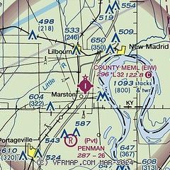
|
| Airport distance calculator |
|---|
|
|
| Sunrise and sunset |
|---|
|
Times for 23-Apr-2024
| | Local
(UTC-5) | | Zulu
(UTC) |
|---|
| Morning civil twilight | | 05:47 | | 10:47 |
| Sunrise | | 06:14 | | 11:14 |
| Sunset | | 19:39 | | 00:39 |
| Evening civil twilight | | 20:06 | | 01:06 |
|
| Current date and time |
|---|
| Zulu (UTC) | 23-Apr-2024 17:48:43 |
|---|
| Local (UTC-5) | 23-Apr-2024 12:48:43 |
|---|
|
| METAR |
|---|
KMAW
19nm W | 231735Z AUTO 20022G27KT 10SM CLR 23/06 A3002 RMK AO1 LTG DSNT NW
|
KTKX
28nm SW | 231735Z AUTO 20018G24KT 5SM HZ CLR 23/08 A3002 RMK AO2
|
KUCY
31nm E | 231735Z AUTO 21015KT 10SM CLR 21/07 A3003 RMK A01
|
KDYR
34nm S | 231656Z AUTO 21010G15KT 180V250 10SM CLR 21/08 A3008 RMK AO2 SLP190 T02060078
|
KCIR
37nm NE | 231735Z AUTO 26015G23KT 10SM OVC075 21/07 A3002 RMK AO2 T02090068
|
KPOF
37nm W | 231653Z AUTO 20015G24KT 10SM CLR 21/08 A3000 RMK AO2 PK WND 20028/1624 SLP156 T02060083
|
KHKA
38nm S | 231653Z AUTO 22018G27KT 10SM -RA CLR 23/04 A3006 RMK AO2 PK WND 21031/1643 SLP177 P0000 T02280039 $
|
|
| TAF |
|---|
KCGI
42nm N | 231120Z 2312/2412 20010KT P6SM FEW250 FM231400 21012G20KT P6SM FEW250 FM232000 22017G25KT P6SM BKN120 FM232300 25010G18KT P6SM VCSH BKN050 FM240200 29008KT P6SM VCSH OVC040 FM240500 VRB04KT P6SM BKN040
|
|
| NOTAMs |
|---|
NOTAMs are issued by the DoD/FAA and will open in a separate window not controlled by AirNav.
|
|
