FAA INFORMATION EFFECTIVE 19 FEBRUARY 2026
Location
| FAA Identifier: | EKQ |
| Lat/Long: | 36-51-19.0000N 084-51-22.1000W
36-51.316667N 084-51.368333W
36.8552778,-84.8561389
(estimated) |
| Elevation: | 962.6 ft. / 293.4 m (surveyed) |
| Variation: | 03W (1990) |
| From city: | 2 miles N of MONTICELLO, KY |
| Time zone: | UTC -5 (UTC -4 during Daylight Saving Time) |
| Zip code: | 42633 |
Airport Operations
| Airport use: | Open to the public |
| Activation date: | 10/1975 |
| Control tower: | no |
| ARTCC: | INDIANAPOLIS CENTER |
| FSS: | LOUISVILLE FLIGHT SERVICE STATION |
| NOTAMs facility: | LOU (NOTAM-D service available) |
| Attendance: | MON-SAT 0830-1730, ALL SUN UNATNDD |
| Wind indicator: | lighted |
| Segmented circle: | yes |
| Lights: | ACTVT REIL RWY 21; PAPI RWY 03/21; MIRL RWY 03/21 - CTAF. LTG PRESET LOW INTST; INCR INTST - CTAF. |
| Beacon: | white-green (lighted land airport)
Operates sunset to sunrise. |
Airport Communications
| CTAF/UNICOM: | 122.8 |
| WX AWOS-3PT: | 118.825 (606-348-0862) |
| WX AWOS-3P at K24 (15 nm NW): | 119.6 (270-343-5556) |
| WX AWOS-3 at SME (17 nm NE): | 120.050 (606-679-5710) |
- APCH/DEP SVC PRVDD BY INDIANAPOLIS ARTCC ON FREQS 124.625/371.925 (LONDON 2 RCAG).
Nearby radio navigation aids
| VOR radial/distance | | VOR name | | Freq | | Var |
|---|
| LVTr045/22.1 | | LIVINGSTON VOR/DME | | 114.35 | | 02W |
| LOZr256/37.3 | | LONDON VOR/DME | | 116.55 | | 03W |
Airport Services
| Fuel available: | 100LL JET-A+
100LL:FUEL AVBL 24/7 WITH CC. |
| Parking: | hangars and tiedowns |
| Airframe service: | NONE |
| Powerplant service: | NONE |
| Bottled oxygen: | NONE |
| Bulk oxygen: | NONE |
Runway Information
Runway 3/21
| Dimensions: | 4000 x 75 ft. / 1219 x 23 m |
| Surface: | asphalt, in good condition |
| Weight bearing capacity: | |
| Runway edge lights: | medium intensity |
| Runway edge markings: | FADED & ALGAE COVERED |
| RUNWAY 3 | | RUNWAY 21 |
| Latitude: | 36-51.048373N | | 36-51.583248N |
| Longitude: | 084-51.607203W | | 084-51.127917W |
| Elevation: | 958.6 ft. | | 962.5 ft. |
| Traffic pattern: | left | | left |
| Runway heading: | 039 magnetic, 036 true | | 219 magnetic, 216 true |
| Markings: | nonprecision, in poor condition | | nonprecision, in poor condition |
| Visual slope indicator: | 4-light PAPI on left (3.00 degrees glide path) | | 4-light PAPI on left (3.00 degrees glide path) |
| Runway end identifier lights: | yes | | yes |
| Touchdown point: | yes, no lights | | yes, no lights |
| Obstructions: | 23 ft. fence, 201 ft. from runway, 250 ft. left of centerline
FENCE 249.5 FT L PARALLEL TO RWY. | | 119 ft. tree, 1971 ft. from runway, 477 ft. right of centerline, 14:1 slope to clear |
Airport Ownership and Management from official FAA records
| Ownership: | Publicly-owned |
| Owner: | WAYNE CO ARPT BOARD
P.O. BOX 439
MONTICELLO, KY 42633
Phone 606-348-4241
606-348-4241 |
| Manager: | JERRY HAMPTON
519 AIRPORT ROAD
MONTICELLO, KY 42633
Phone (661) 205-6415 |
Additional Remarks
| - | FOR CD CTC INDIANAPOLIS ARTCC AT 317-247-2411. |
Instrument Procedures
NOTE: All procedures below are presented as PDF files. If you need a reader for these files, you should download the free Adobe Reader.NOT FOR NAVIGATION. Please procure official charts for flight.
FAA instrument procedures published for use from 19 February 2026 at 0901Z to 19 March 2026 at 0900Z.
IAPs - Instrument Approach Procedures |
|---|
| RNAV (GPS) RWY 03 **CHANGED** | |
download (242KB) |
| RNAV (GPS) RWY 21 **CHANGED** | |
download (229KB) |
| NOTE: Special Alternate Minimums apply | |
download (27KB) |
| NOTE: Special Take-Off Minimums/Departure Procedures apply | |
download (126KB) |
Other nearby airports with instrument procedures:
K24 - Russell County Airport (15 nm NW)
KSME - Lake Cumberland Regional Airport (17 nm NE)
18I - Mc Creary County Airport (24 nm SE)
KSCX - Scott Municipal Airport (27 nm SE)
2A1 - Jamestown Municipal Airport (31 nm S)
|
|

Road maps at:
MapQuest
Bing
Google
| Aerial photo |
|---|
WARNING: Photo may not be current or correct

Do you have a better or more recent aerial photo of Wayne County Airport that you would like to share? If so, please send us your photo.
|
| Sectional chart |
|---|
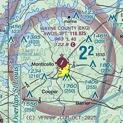
|
| Airport distance calculator |
|---|
|
|
| Sunrise and sunset |
|---|
|
Times for 28-Feb-2026
| | Local
(UTC-5) | | Zulu
(UTC) |
|---|
| Morning civil twilight | | 06:47 | | 11:47 |
| Sunrise | | 07:13 | | 12:13 |
| Sunset | | 18:31 | | 23:31 |
| Evening civil twilight | | 18:57 | | 23:57 |
|
| Current date and time |
|---|
| Zulu (UTC) | 28-Feb-2026 08:37:37 |
|---|
| Local (UTC-5) | 28-Feb-2026 03:37:37 |
|---|
|
| METAR |
|---|
| KEKQ | 280756Z AUTO 29003KT 10SM CLR M01/M01 A3005 RMK AO2 SLP174 T10061006 PNO $
|
KSME
16nm NE | 280815Z AUTO 00000KT 10SM CLR 02/02 A3000 RMK AO2
|
|
| TAF |
|---|
KSME
16nm NE | 280520Z 2806/0106 VRB03KT P6SM SKC
|
|
| NOTAMs |
|---|
NOTAMs are issued by the DoD/FAA and will open in a separate window not controlled by AirNav.
|
|

