FAA INFORMATION EFFECTIVE 11 JUNE 2026
Location
| FAA Identifier: | EWN |
| Lat/Long: | 35-04-22.2760N 077-02-34.8710W
35-04.371267N 077-02.581183W
35.0728544,-77.0430197
(estimated) |
| Elevation: | 17.9 ft. / 5.5 m (surveyed) |
| Variation: | 08W (1985) |
| From city: | 3 miles SE of NEW BERN, NC |
| Time zone: | UTC -4 (UTC -5 during Standard Time) |
| Zip code: | 28562 |
Airport Operations
| Airport use: | Open to the public |
| Activation date: | 07/1941 |
| Control tower: | yes |
| ARTCC: | WASHINGTON CENTER |
| FSS: | RALEIGH FLIGHT SERVICE STATION |
| NOTAMs facility: | EWN (NOTAM-D service available) |
| Attendance: | 0500-2330 |
| Wind indicator: | lighted |
| Segmented circle: | no |
| Lights: | ACTVT REIL RWY 04, 22, 14 & 32; HIRL 04/22; MIRL 14/32 - CTAF. PAPI RWY 04, 22, 14 & 32 OPER CONSLY. |
| Beacon: | white-green (lighted land airport)
Operates sunset to sunrise. |
| Fire and rescue: | ARFF index B |
| Airline operations: | CLSD TO UNSKED ACR OPNS WITH MORE THAN 30 PSGR SEATS EXCP 24 HR PPR CALL AMGR 252-638-8591. |
Airport Communications
| CTAF: | 124.25 |
| WX ASOS: | 118.525 (252-514-2086) |
| NEW BERN GROUND: | 121.7 [0600-2200] |
| NEW BERN TOWER: | 124.25 [0600-2200] |
| CHERRY POINT APPROACH: | 119.35 |
| CHERRY POINT DEPARTURE: | 119.35 |
| CLEARANCE DELIVERY: | 120.525 ;WHEN EWN TWR CLSD 121.7 |
| EMERG: | 121.5 |
- APCH/DEP SVC PRVDD BY NAS CHERRY POINT APCH CNTL ON FREQ 120.525.
Nearby radio navigation aids
| VOR radial/distance | | VOR name | | Freq | | Var |
|---|
| EWN at field | | NEW BERN VOR/DME | | 113.60 | | 08W |
| ISOr130/30.9 | | KINSTON VORTAC | | 117.50 | | 05W |
| NDB name | | Hdg/Dist | | Freq | | Var | | ID |
|---|
| KATFI | | 038/3.6 | | 362 | | 08W | | EW | . .-- |
| CHOCOWINITY | | 181/26.4 | | 388 | | 08W | | RNW | .-. -. .-- |
Airport Services
| Fuel available: | 100LL JET-A |
| Parking: | hangars and tiedowns |
| Airframe service: | MAJOR |
| Powerplant service: | MAJOR |
| Bottled oxygen: | NONE |
| Bulk oxygen: | NONE |
Runway Information
Runway 4/22
| Dimensions: | 6452 x 150 ft. / 1967 x 46 m |
| Surface: | asphalt/grooved, in good condition |
| Weight bearing capacity: | | Single wheel: | 80.0 | | Double wheel: | 123.0 |
|
| Runway edge lights: | high intensity |
| RUNWAY 4 | | RUNWAY 22 |
| Latitude: | 35-03.884003N | | 35-04.798432N |
| Longitude: | 077-02.927338W | | 077-02.266663W |
| Elevation: | 13.4 ft. | | 14.5 ft. |
| Traffic pattern: | left | | left |
| Runway heading: | 039 magnetic, 031 true | | 219 magnetic, 211 true |
| Displaced threshold: | 299 ft. | | no |
| Declared distances: | TORA:6453 TODA:6453 ASDA:6053 LDA:5753 | | TORA:6453 TODA:6453 ASDA:6153 LDA:6153 |
| Markings: | precision, in good condition | | precision, in good condition |
| Visual slope indicator: | 4-light PAPI on left (3.00 degrees glide path) | | 4-light PAPI on left (3.00 degrees glide path) |
| Runway end identifier lights: | yes | | yes |
| Touchdown point: | yes, no lights | | yes, no lights |
| Instrument approach: | ILS | | |
| Obstructions: | none | | 68 ft. trees, 2543 ft. from runway, 558 ft. left of centerline, 34:1 slope to clear |
Runway 14/32
| Dimensions: | 4001 x 150 ft. / 1220 x 46 m |
| Surface: | asphalt, in good condition |
| Weight bearing capacity: | | Single wheel: | 28.0 | | Double wheel: | 45.0 |
|
| Runway edge lights: | medium intensity |
| Operational restrictions: | RWY 14/32 NOT AVBL FOR PART 121/PART 380 OPS WITH SKED PAX CARRYING OPS MORE THAN 9 PAX SEATS AND NON-SKED PAX CARRYING OPS MORE THAN 30 PAX SEATS. |
| RUNWAY 14 | | RUNWAY 32 |
| Latitude: | 35-04.622387N | | 35-04.216995N |
| Longitude: | 077-02.871970W | | 077-02.239283W |
| Elevation: | 11.6 ft. | | 17.6 ft. |
| Traffic pattern: | left | | left |
| Runway heading: | 136 magnetic, 128 true | | 316 magnetic, 308 true |
| Markings: | nonprecision, in good condition | | nonprecision, in good condition |
| Visual slope indicator: | 2-light PAPI on left (4.00 degrees glide path) | | 2-light PAPI on left (3.00 degrees glide path) |
| Runway end identifier lights: | yes | | yes |
| Touchdown point: | yes, no lights | | yes, no lights |
| Obstructions: | 28 ft. trees, 1000 ft. from runway, 500 ft. right of centerline, 20:1 slope to clear | | 26 ft. tree, 862 ft. from runway, 80 ft. left of centerline, 25:1 slope to clear |
Airport Ownership and Management from official FAA records
| Ownership: | Publicly-owned |
| Owner: | CRAVEN COUNTY
PO BOX 3258
NEW BERN, NC 28560
Phone 252-638-8591 |
| Manager: | ANDREW SHORTER
200 TERMINAL DRIVE
NEW BERN, NC 28562-6455
Phone 252-638-8591 |
Additional Remarks
| A39-14/32 | PCR VALUE: 250/F/C/X/T |
| A39-04/22 | PCR VALUE: 250/F/B/X/T |
| E60-22 | ARRESTING GEAR/SYSTEM: ENGINEERED MATERIALS ARRESTING SYSTEM (EMAS) 279.42 FT IN LENGTH BY 162 FT IN WIDTH LOCATED AT THE DEPARTURE END OF RWY 22. |
| - | MIL TACTICAL JET ACFT; STRAIGHT IN, FULL STOP LDGS ONLY; RWY 14/32 FOR EUO. |
| - | RWY 14/32 ASSOCD TWYS NOT AVBL FOR SKED ACR OPNS WITH MORE THAN 9 PSGR SEATS OR UNSKED ACR AT LEAST 31 PSGR SEATS. |
Instrument Procedures
NOTE: All procedures below are presented as PDF files. If you need a reader for these files, you should download the free Adobe Reader.NOT FOR NAVIGATION. Please procure official charts for flight.
FAA instrument procedures published for use from 11 June 2026 at 0901Z to 09 July 2026 at 0900z.
IAPs - Instrument Approach Procedures |
|---|
| ILS OR LOC RWY 04 | |
download (251KB) |
| RNAV (GPS) RWY 04 | |
download (205KB) |
| RNAV (GPS) RWY 22 | |
download (272KB) |
| VOR RWY 22 | |
download (269KB) |
| NOTE: Special Alternate Minimums apply | |
download (155KB) |
| NOTE: Special Take-Off Minimums/Departure Procedures apply | |
download (141KB) |
Other nearby airports with instrument procedures:
KNKT - Cherry Point Marine Corps Air Station (Cunningham Field) Airport (13 nm SE)
KMRH - Michael J Smith Field Airport (28 nm SE)
KNCA - New River Marine Corps Air Station (McCutcheon Field) Airport (29 nm SW)
KOCW - Washington-Warren Airport (30 nm N)
KOAJ - Albert J Ellis Airport (32 nm SW)
|
|

Road maps at:
MapQuest
Bing
Google
| Aerial photo |
|---|
WARNING: Photo may not be current or correct
 Photo by Mr. Verdier
Taken in October 2014
looking north.
Photo by Mr. Verdier
Taken in October 2014
looking north.
Do you have a better or more recent aerial photo of Coastal Carolina Regional Airport that you would like to share? If so, please send us your photo.
|
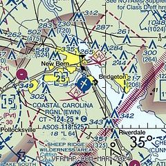
| Sectional chart |
|---|
|
 Download PDF
of official airport diagram from the FAA
| Airport distance calculator |
|---|
|
|
| Sunrise and sunset |
|---|
|
Times for 21-Jun-2026
| | Local
(UTC-4) | | Zulu
(UTC) |
|---|
| Morning civil twilight | | 05:26 | | 09:26 |
| Sunrise | | 05:55 | | 09:55 |
| Sunset | | 20:24 | | 00:24 |
| Evening civil twilight | | 20:54 | | 00:54 |
|
| Current date and time |
|---|
| Zulu (UTC) | 21-Jun-2026 21:44:04 |
|---|
| Local (UTC-4) | 21-Jun-2026 17:44:04 |
|---|
|
| METAR |
|---|
| KEWN | 212054Z 18011KT 10SM CLR 32/16 A2994 RMK AO2 SLP138 T03220161 55002
|
KNKT
14nm SE | 212055Z 18011KT 10SM FEW060 31/17 A2996 RMK AO2 SLP140 T03060172 53001
|
|
| TAF |
|---|
| KEWN | 211722Z 2118/2218 VRB04KT P6SM FEW050 FEW250 FM212000 17011KT P6SM FEW250 FM220000 18005KT P6SM FEW250 FM221500 19010KT P6SM FEW250
|
KNKT
14nm SE | 211400Z 2115/2215 VRB06KT 9999 BKN150 532409 533309 534201 QNH2992INS FM212300 18007KT 9999 SCT200 500000 QNH2994INS TEMPO 2123/2204 18007G17KT TEMPO 2208/2214 6000 BR BKN010 FM221430 20012G25KT 9999 FEW050 SCT200 QNH299INS TX32/2118Z TN23/2206Z
|
|
| NOTAMs |
|---|
NOTAMs are issued by the DoD/FAA and will open in a separate window not controlled by AirNav.
|
|


