FAA INFORMATION EFFECTIVE 09 JULY 2026
Location
| FAA Identifier: | FLY |
| Lat/Long: | 38-56-33.9710N 104-34-11.6570W
38-56.566183N 104-34.194283W
38.9427697,-104.5699047
(estimated) |
| Elevation: | 6878.1 ft. / 2096.4 m (surveyed) |
| Variation: | 07E (2025) |
| From city: | 14 miles NE of COLORADO SPRINGS, CO |
| Time zone: | UTC -6 (UTC -7 during Standard Time) |
| Zip code: | 80831 |
Airport Operations
| Airport use: | Open to the public |
| Activation date: | 11/1967 |
| Control tower: | no |
| ARTCC: | DENVER CENTER |
| FSS: | DENVER FLIGHT SERVICE STATION |
| NOTAMs facility: | DEN (NOTAM-D service available) |
| Attendance: | 0800-1700 |
| Wind indicator: | lighted |
| Segmented circle: | yes |
| Lights: | ACTVT REIL RWY 15 & 33; ACTVT & INCR INTST MIRL RWY 15/33 - CTAF. PAPI RWY 15 & 33 ON CONSLY. |
| Beacon: | white-green (lighted land airport)
Operates sunset to sunrise. |
Airport Communications
| CTAF/UNICOM: | 122.7 |
| WX AWOS-3PT: | 118.450 (719-683-5371) |
| SPRINGS APPROACH: | 124.0 |
| SPRINGS DEPARTURE: | 124.0 |
| WX ASOS at COS (10 nm SW): | 125.0 (719-694-7502) |
| WX ASOS at CO90 (17 nm SE): | 125.0 (719-637-9696) |
| WX AWOS-3 at FCS (18 nm SW): | 125.0 (719-637-9696) |
Nearby radio navigation aids
| VOR radial/distance | | VOR name | | Freq | | Var |
|---|
| BRKr084/3.0 | | BLACK FOREST VOR/DME | | 112.50 | | 08E |
| FCSr017/18.0 | | BUTTS VOR/DME | | 108.80 | | 12E |
| PUBr342/39.5 | | PUEBLO VORTAC | | 116.70 | | 08E |
| NDB name | | Hdg/Dist | | Freq | | Var | | ID |
|---|
| IRONHORSE | | 020/18.0 | | 335 | | 08E | | IHS | .. .... ... |
Airport Services
| Fuel available: | 100LL
100LL:100LL AVBL 24 HRS SELF SVC CREDIT CARD. |
| Parking: | hangars and tiedowns |
| Airframe service: | MAJOR |
| Powerplant service: | MAJOR |
| Bottled oxygen: | NONE |
| Bulk oxygen: | LOW |
Runway Information
Runway 15/33
| Dimensions: | 6001 x 60 ft. / 1829 x 18 m |
| Surface: | asphalt, in excellent condition |
| Weight bearing capacity: | |
| Runway edge lights: | medium intensity |
| RUNWAY 15 | | RUNWAY 33 |
| Latitude: | 38-57.208218N | | 38-56.276998N |
| Longitude: | 104-34.476790W | | 104-34.053608W |
| Elevation: | 6878.1 ft. | | 6791.4 ft. |
| Traffic pattern: | left | | right |
| Runway heading: | 153 magnetic, 160 true | | 333 magnetic, 340 true |
| Markings: | nonprecision, in poor condition | | nonprecision, in poor condition |
| Visual slope indicator: | 2-light PAPI on left (3.50 degrees glide path) | | 2-light PAPI on left (3.00 degrees glide path) |
| Runway end identifier lights: | yes | | yes |
| Touchdown point: | yes, no lights | | yes, no lights |
| Obstructions: | 18 ft. road, 558 ft. from runway, 115 ft. left of centerline, 19:1 slope to clear | | none |
Runway 8/26
| Dimensions: | 2126 x 35 ft. / 648 x 11 m
RWY 08/26 1149 FT GRVL ON E END OF RWY, 925 FT ASPH ON W END OF RWY. |
| Surface: | asphalt/gravel, in fair condition |
| RUNWAY 8 | | RUNWAY 26 |
| Latitude: | 38-56.756453N | | 38-56.750192N |
| Longitude: | 104-34.228658W | | 104-33.780433W |
| Elevation: | 6824.8 ft. | | 6799.4 ft. |
| Traffic pattern: | right | | left |
| Runway heading: | 084 magnetic, 091 true | | 264 magnetic, 271 true |
| Markings: | none, in poor condition | | none, in poor condition |
| Touchdown point: | yes, no lights | | yes, no lights |
Runway 16/34
| Dimensions: | 5001 x 200 ft. / 1524 x 61 m |
| Surface: | turf, in fair condition |
| RUNWAY 16 | | RUNWAY 34 |
| Latitude: | 38-56.662995N | | 38-55.886910N |
| Longitude: | 104-34.366322W | | 104-34.013498W |
| Elevation: | 6776.8 ft. | | 6776.8 ft. |
| Traffic pattern: | left | | left |
| Runway heading: | 153 magnetic, 160 true | | 333 magnetic, 340 true |
| Markings: | none, in poor condition | | none, in poor condition |
| Touchdown point: | yes, no lights | | yes, no lights |
| Obstructions: | 7 ft. berm, 72 ft. from runway, 102 ft. right of centerline, 10:1 slope to clear | | none |
Airport Ownership and Management from official FAA records
| Ownership: | Privately-owned |
| Owner: | MEADOW LAKE AIRPORT ASSOC., INC.
13625 JUDGE ORR ROAD
PEYTON, CO 80831
Phone 719-339-0928
DAVE ELLIOTT ASSOCIATION PRESIDENT. |
| Manager: | DAVE ELLIOTT
13625 JUDGE ORR ROAD
PEYTON, CO 80831
Phone 719-339-0928
ALTN PHONE IS MIKE BARR AT (719) 287-4204 |
Additional Remarks
| - | CTN: ; INTENSIVE USAF STUDENT TNG INVOF COLORADO SPRINGS & PUEBLO COLORADO. |
| - | RWY 26: 15 FT ROAD EXTDS EAST FM THLD. |
| - | CTN: PWRD PARAGLIDERS AND MOBILE AEROSTATS OPER SOUTHEAST SIDE OF ARPT SFC-500 FT. |
| - | RWY 16/34 HAS EDGES AND THLDS MKD WITH WHITE TIRES. |
| - | FOR CD CTC COLORADO SPRINGS APCH AT 719-556-9105. |
| - | RWY 08/26 EDGES MKD WITH WHITE REFLECTORS AND TIRES. |
| - | GLIDERS OPERATE ON 16/34 AND WEST SIDE OF ARPT. |
| - | RWY 26; 4 FT TERRAIN 5 FT FM RWY EDGE FIRST 100 FT ON BOTH SIDES OF RWY. |
| - | WILDLIFE ON AND INVOF OF AIRPORT. |
| - | RWY 26; 4 FT FENCE 50 FT RIGHT OF CNTRLN 95 FT FM THLD. |
Instrument Procedures
NOTE: All procedures below are presented as PDF files. If you need a reader for these files, you should download the free Adobe Reader.NOT FOR NAVIGATION. Please procure official charts for flight.
FAA instrument procedures published for use from 09 July 2026 at 0901Z to 06 August 2026 at 0900Z.
IAPs - Instrument Approach Procedures |
|---|
| RNAV (GPS) RWY 15 | |
download (269KB) |
| RNAV (GPS) RWY 33 | |
download (246KB) |
| NOTE: Special Alternate Minimums apply | |
download (144KB) |
|
|---|
| FALCON ONE (OBSTACLE) (RNAV) | |
download (401KB) |
| NOTE: Special Take-Off Minimums/Departure Procedures apply | |
download (287KB) |
Other nearby airports with instrument procedures:
KCOS - City of Colorado Springs Municipal Airport (10 nm SW)
KFCS - Butts Army Airfield (Fort Carson) (18 nm SW)
KPUB - Pueblo Memorial Airport (39 nm S)
1V6 - Fremont County Airport (40 nm SW)
KAPA - Centennial Airport (40 nm N)
|
|

Road maps at:
MapQuest
Bing
Google
| Aerial photo |
|---|
WARNING: Photo may not be current or correct
 Photo by Mitch Bowers
WWW.IMAGEWERX.US
Photo taken 16-May-2018
looking northwest.
Do you have a better or more recent aerial photo of Meadow Lake Airport that you would like to share? If so, please send us your photo.
|
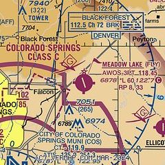
| Sectional chart |
|---|
|
| Airport distance calculator |
|---|
|
|
| Sunrise and sunset |
|---|
|
Times for 11-Jul-2026
| | Local
(UTC-6) | | Zulu
(UTC) |
|---|
| Morning civil twilight | | 05:12 | | 11:12 |
| Sunrise | | 05:43 | | 11:43 |
| Sunset | | 20:24 | | 02:24 |
| Evening civil twilight | | 20:56 | | 02:56 |
|
| Current date and time |
|---|
| Zulu (UTC) | 11-Jul-2026 16:01:01 |
|---|
| Local (UTC-6) | 11-Jul-2026 10:01:01 |
|---|
|
| METAR |
|---|
| KFLY | 111535Z AUTO 15003KT 10SM CLR 25/09 A3032 RMK AO2 T02530088
|
KCOS
10nm SW | 111554Z 11005KT 10SM FEW020 FEW120 25/09 A3026 RMK AO2 SLP153 FU FEW020 T02500094 $
|
KAFF
12nm W | 111455Z AUTO 00000KT 10SM CLR 23/08 A3027 RMK AO2 SLP149 T02250075 50004
|
KMNH
17nm N | 111535Z AUTO 25005KT 10SM CLR 26/06 A3033 RMK AO2
|
KCWN
18nm SW | 111455Z AUTO 03005KT 10SM CLR 24/10 A3029 RMK AO2 SLP064 T02400096 52007 $
|
KFCS
19nm SW | 111455Z AUTO 05006KT 10SM CLR 20/09 A3024 RMK AO2 SLP182 T02020088 51003 $
|
|
| TAF |
|---|
KCOS
10nm SW | 111122Z 1112/1212 02006KT P6SM SKC FM111700 15008KT P6SM FEW200 FM111900 13010G20KT P6SM BKN250 FM120000 13010KT P6SM BKN250 FM120400 12005KT P6SM FEW200 FM120700 02005KT P6SM SKC
|
KAFF
12nm W | 110022Z 1019/1201 12012G18KT 9999 VCTS SCT100CB BKN200 QNH3012INS WND 080V170 TEMPO 1020/1101 VRB20G35KT -TSRA SCT080 BKN100CB BECMG 1100/1101 16012KT 9999 VCSH SCT100 QNH3017INS BECMG 1105/1106 35009KT 9999 NSW FEW100 QNH3020INS BECMG 1114/1115 16012KT 9999 FEW100 QNH3022INS BECMG 1119/1120 16012G20KT 9999 VCTS FEW100CB QNH3028INS TEMPO 1120/1201 VRB25G35KT -TSRA SCT080 BKN100CB TX30/1022Z TN10/1110Z LAST NO AMDS AFT 1100 NEXT 1311
|
KFCS
19nm SW | 110400Z 1104/1210 33006KT 9999 FEW100 QNH3025INS BECMG 1115/1116 15009KT 9999 FEW110 QNH3027INS BECMG 1118/1119 15010G20KT 9999 VCTS BKN120CB QNH3028INS TEMPO 1120/1124 VRB20G30KT 9000 -TSRA BKN110CB BECMG 1201/1202 32009KT 9999 NSW SCT110 QNH3024INS BECMG 1206/1207 36006KT 9999 SKC QNH3020INS TX31/1122Z TN10/1111Z LAST NO AMDS AFT 1104 NEXT 1312
|
|
| NOTAMs |
|---|
NOTAMs are issued by the DoD/FAA and will open in a separate window not controlled by AirNav.
|
|

