FAA INFORMATION EFFECTIVE 11 JUNE 2026
Location
| FAA Identifier: | GPC |
| Lat/Long: | 39-38-00.7000N 086-48-49.7000W
39-38.011667N 086-48.828333W
39.6335278,-86.8138056
(estimated) |
| Elevation: | 842 ft. / 256.6 m (surveyed) |
| Variation: | 03W (2005) |
| From city: | 3 miles SE of GREENCASTLE, IN |
| Time zone: | UTC -4 (UTC -5 during Standard Time) |
| Zip code: | 46135 |
Airport Operations
| Airport use: | Open to the public |
| Activation date: | 01/1947 |
| Control tower: | no |
| ARTCC: | INDIANAPOLIS CENTER |
| FSS: | TERRE HAUTE FLIGHT SERVICE STATION |
| NOTAMs facility: | HUF (NOTAM-D service available) |
| Attendance: | 0800-1630 |
| Wind indicator: | lighted |
| Segmented circle: | no |
| Lights: | ACTVT MIRL RWY 18/36 - CTAF; PAPI RWY 18 & 36 OPR CONSLY. |
| Beacon: | white-green (lighted land airport)
Operates sunset to sunrise. |
Airport Communications
| CTAF/UNICOM: | 122.8 |
| WX AWOS-3PT: | 118.125 (765-653-1789) |
| INDIANAPOLIS APPROACH: | 119.05 |
| INDIANAPOLIS DEPARTURE: | 119.05 |
| WX AWOS-3PT at 2R2 (17 nm NE): | 118.025 (317-718-4872) |
Nearby radio navigation aids
| VOR radial/distance | | VOR name | | Freq | | Var |
|---|
| TTHr065/21.9 | | TERRE HAUTE VORTAC | | 115.30 | | 02E |
| VHPr241/23.3 | | BRICKYARD VORTAC | | 116.30 | | 01E |
| OOMr344/30.8 | | HOOSIER VORTAC | | 110.20 | | 02W |
| NDB name | | Hdg/Dist | | Freq | | Var | | ID |
|---|
| CRAWFORDSVILLE | | 171/21.4 | | 388 | | 04W | | CFJ | -.-. ..-. .--- |
Airport Services
| Fuel available: | 100LL JET-A1+ |
| Parking: | hangars and tiedowns |
| Airframe service: | MAJOR |
| Powerplant service: | MAJOR |
Runway Information
Runway 18/36
| Dimensions: | 5002 x 100 ft. / 1525 x 30 m |
| Surface: | asphalt/grooved, in excellent condition |
| Runway edge lights: | medium intensity |
| RUNWAY 18 | | RUNWAY 36 |
| Latitude: | 39-38.424265N | | 39-37.600495N |
| Longitude: | 086-48.818723W | | 086-48.839270W |
| Elevation: | 842.0 ft. | | 814.2 ft. |
| Traffic pattern: | left | | left |
| Runway heading: | 184 magnetic, 181 true | | 004 magnetic, 001 true |
| Markings: | nonprecision, in good condition | | nonprecision, in good condition |
| Visual slope indicator: | 2-light PAPI on left (3.00 degrees glide path) | | 2-light PAPI on left (3.00 degrees glide path) |
| Runway end identifier lights: | yes | | no |
| Touchdown point: | yes, no lights | | yes, no lights |
| Obstructions: | 10 ft. crops, 420 ft. from runway, 22:1 slope to clear
APCH RATIO 42:1 TO THR. | | 13 ft. road, 610 ft. from runway, 280 ft. left of centerline, 31:1 slope to clear
APCH RATIO 46:1 TO THR. |
Airport Ownership and Management from official FAA records
| Ownership: | Publicly-owned |
| Owner: | PUTNAM CO AIRPORT AUTHORITY
1595 BALLARD LANE
GREENCASTLE, IN 46135
Phone 765-653-1763 |
| Manager: | P. DOUGLAS MILLER
1595 BALLARD LANE, PO BOX 318
GREENCASTLE, IN 46135
Phone 765-721-1289 |
Additional Remarks
| - | FOR CD CTC INDIANAPOLIS APCH AT 317-227-5743. |
Instrument Procedures
NOTE: All procedures below are presented as PDF files. If you need a reader for these files, you should download the free Adobe Reader.NOT FOR NAVIGATION. Please procure official charts for flight.
FAA instrument procedures published for use from 11 June 2026 at 0901Z to 09 July 2026 at 0900z.
IAPs - Instrument Approach Procedures |
|---|
| RNAV (GPS) RWY 18 | |
download (225KB) |
| RNAV (GPS) RWY 36 **CHANGED** | |
download (216KB) |
| VOR-A **CHANGED** | |
download (156KB) |
| NOTE: Special Alternate Minimums apply | |
download (150KB) |
| NOTE: Special Take-Off Minimums/Departure Procedures apply | |
download (247KB) |
Other nearby airports with instrument procedures:
0I2 - Brazil Clay County Airport/Charles B Hall Field (16 nm SW)
2R2 - Hendricks County Airport-Gordon Graham Field (17 nm NE)
KCFJ - Crawfordsville Regional Airport (21 nm N)
KIND - Indianapolis International Airport (24 nm E)
KHUF - Terre Haute Regional Airport (25 nm SW)
|
|

Road maps at:
MapQuest
Bing
Google
| Aerial photo |
|---|
WARNING: Photo may not be current or correct
 Photo courtesy of Butler, Fairman & Seufert
Photo taken 22-Aug-2014
looking south.
Photo courtesy of Butler, Fairman & Seufert
Photo taken 22-Aug-2014
looking south.
Do you have a better or more recent aerial photo of Putnam County Regional Airport that you would like to share? If so, please send us your photo.
|
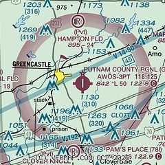
| Sectional chart |
|---|
|
| Airport distance calculator |
|---|
|
|
| Sunrise and sunset |
|---|
|
Times for 23-Jun-2026
| | Local
(UTC-4) | | Zulu
(UTC) |
|---|
| Morning civil twilight | | 05:49 | | 09:49 |
| Sunrise | | 06:21 | | 10:21 |
| Sunset | | 21:18 | | 01:18 |
| Evening civil twilight | | 21:50 | | 01:50 |
|
| Current date and time |
|---|
| Zulu (UTC) | 23-Jun-2026 16:25:29 |
|---|
| Local (UTC-4) | 23-Jun-2026 12:25:29 |
|---|
|
| METAR |
|---|
| KGPC | 231555Z AUTO 34007KT 10SM CLR 22/15 A3018 RMK AO2 T02170151
|
|
| TAF |
|---|
KIND
25nm E | 231120Z 2312/2418 35008KT P6SM FEW250 FM231700 34010KT P6SM SCT050 FM240100 01006KT P6SM SCT250
|
KHUF
26nm SW | 231120Z 2312/2412 35005KT P6SM FEW250 FM231700 35008KT P6SM FEW050 FM240100 VRB03KT P6SM SCT250
|
KBMG
30nm S | 231120Z 2312/2412 36005KT P6SM FEW250 FM231700 35008KT P6SM SCT050 FM240100 VRB03KT P6SM SCT250
|
|
| NOTAMs |
|---|
NOTAMs are issued by the DoD/FAA and will open in a separate window not controlled by AirNav.
|
|

