FAA INFORMATION EFFECTIVE 14 MAY 2026
Location
| FAA Identifier: | HEE |
| Lat/Long: | 34-34-35.3710N 090-40-33.2020W
34-34.589517N 090-40.553367W
34.5764919,-90.6758894
(estimated) |
| Elevation: | 241.7 ft. / 73.7 m (surveyed) |
| Variation: | 01E (2000) |
| From city: | 5 miles NW of central business district of the associated city |
| Time zone: | UTC -5 (UTC -6 during Standard Time) |
| Zip code: | 72355 |
Airport Operations
| Airport use: | Open to the public |
| Activation date: | 09/1942 |
| Control tower: | no |
| ARTCC: | MEMPHIS CENTER |
| FSS: | JONESBORO FLIGHT SERVICE STATION |
| NOTAMs facility: | JBR (NOTAM-D service available) |
| Attendance: | MON-FRI DAYLIGHT HOURS, ALL SAT 0800-1200 |
| Pattern altitude: | 1201.7 ft. MSL |
| Wind indicator: | lighted |
| Segmented circle: | yes |
| Lights: | ACTVT MIRL RWY 09/27 & 18/36 - CTAF. PAPI RWY 18 & 36 ON CONSLY. |
| Beacon: | white-green (lighted land airport)
Operates sunset to sunrise. |
| Taxiway lights: | TWY EXIT & GUIDANCE SIGNS. |
Airport Communications
| CTAF/UNICOM: | 122.8 |
| WX AWOS-3 at UTA (17 nm E): | 118.075 (662-363-1652) |
| WX AWOS-3 at CKM (18 nm SE): | 120.675 (662-624-9777) |
- APCH/DEP SVC PRVDD BY MEMPHIS ARTCC ON FREQS 135.3/335.8(BRINKLEY RCAG).
Nearby radio navigation aids
| VOR radial/distance | | VOR name | | Freq | | Var |
|---|
| UJM at field | | MARVELL VOR/DME | | 113.65 | | 01E |
Airport Services
| Fuel available: | 100LL JET-A |
| Parking: | hangars and tiedowns |
| Airframe service: | MAJOR |
| Powerplant service: | MAJOR |
| Bottled oxygen: | NONE |
| Bulk oxygen: | NONE |
Runway Information
Runway 18/36
| Dimensions: | 5001 x 100 ft. / 1524 x 30 m |
| Surface: | asphalt/grooved, in good condition |
| Weight bearing capacity: | |
| Runway edge lights: | medium intensity |
| RUNWAY 18 | | RUNWAY 36 |
| Latitude: | 34-35.153407N | | 34-34.329075N |
| Longitude: | 090-40.656912W | | 090-40.664915W |
| Elevation: | 241.0 ft. | | 237.6 ft. |
| Traffic pattern: | left | | left |
| Runway heading: | 179 magnetic, 180 true | | 359 magnetic, 000 true |
| Markings: | nonprecision, in good condition | | nonprecision, in good condition |
| Visual slope indicator: | 4-light PAPI on left (3.00 degrees glide path) | | 4-light PAPI on left (3.00 degrees glide path) |
| Runway end identifier lights: | yes | | yes |
| Touchdown point: | yes, no lights | | yes, no lights |
Runway 9/27
| Dimensions: | 3011 x 60 ft. / 918 x 18 m |
| Surface: | asphalt, in fair condition |
| Weight bearing capacity: | |
| Runway edge lights: | medium intensity |
| RUNWAY 9 | | RUNWAY 27 |
| Latitude: | 34-34.337838N | | 34-34.337177N |
| Longitude: | 090-40.674782W | | 090-40.074725W |
| Elevation: | 237.1 ft. | | 241.7 ft. |
| Traffic pattern: | left | | left |
| Runway heading: | 089 magnetic, 090 true | | 269 magnetic, 270 true |
| Markings: | basic, in good condition | | basic, in good condition |
| Touchdown point: | yes, no lights | | yes, no lights |
| Obstructions: | 25 ft. tree, 725 ft. from runway, 115 ft. right of centerline, 20:1 slope to clear | | none |
Airport Ownership and Management from official FAA records
| Ownership: | Publicly-owned |
| Owner: | HELENA WEST HELENA
CITY OF HELENA / WEST HELENA, 226 PERRY STR
HELENA, AR 72342
Phone (870) 817-7400 |
| Manager: | BILL BROTHERS
PO BOX 2948
WEST HELENA, AR 72390
Phone 870-714-1844 |
Additional Remarks
| - | NUMEROUS AGRICULTURE OPS FEB THRU OCT. |
| - | FOR CD CTC MEMPHIS ARTCC AT 901-368-8453/8449. |
Instrument Procedures
NOTE: All procedures below are presented as PDF files. If you need a reader for these files, you should download the free Adobe Reader.NOT FOR NAVIGATION. Please procure official charts for flight.
FAA instrument procedures published for use from 14 May 2026 at 0901Z to 11 June 2026 at 0900Z.
IAPs - Instrument Approach Procedures |
|---|
| RNAV (GPS) RWY 18 | |
download (226KB) |
| RNAV (GPS) RWY 36 | |
download (214KB) |
| NOTE: Special Take-Off Minimums/Departure Procedures apply | |
download (390KB) |
Other nearby airports with instrument procedures:
6M7 - Marianna/Lee County Airport-Steve Edwards Field (14 nm NW)
KUTA - Tunica Municipal Airport (17 nm E)
KCKM - Fletcher Field Airport (18 nm SE)
KMMS - Selfs Airport (28 nm SE)
M36 - Frank Federer Memorial Airport (31 nm NW)
|
|

Road maps at:
MapQuest
Bing
Google
| Aerial photo |
|---|
WARNING: Photo may not be current or correct
 Photo courtesy of the Arkansas Department of Aeronautics
Taken in the Spring of 2007
Photo courtesy of the Arkansas Department of Aeronautics
Taken in the Spring of 2007
Do you have a better or more recent aerial photo of Thompson-Robbins Airport that you would like to share? If so, please send us your photo.
|
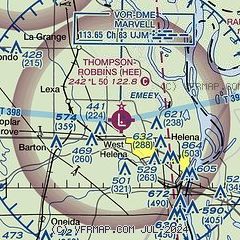
| Sectional chart |
|---|
|
| Airport distance calculator |
|---|
|
|
| Sunrise and sunset |
|---|
|
Times for 06-Jun-2026
| | Local
(UTC-5) | | Zulu
(UTC) |
|---|
| Morning civil twilight | | 05:22 | | 10:22 |
| Sunrise | | 05:51 | | 10:51 |
| Sunset | | 20:12 | | 01:12 |
| Evening civil twilight | | 20:41 | | 01:41 |
|
| Current date and time |
|---|
| Zulu (UTC) | 06-Jun-2026 20:48:43 |
|---|
| Local (UTC-5) | 06-Jun-2026 15:48:43 |
|---|
|
| METAR |
|---|
KUTA
17nm E | 062035Z AUTO 11009KT 10SM SCT250 32/21 A2993 RMK AO2 T03170205 $
|
KCKM
18nm SE | 062035Z AUTO RMK A01 PNO
|
KDRP
33nm N | 062035Z AUTO 15009KT 10SM CLR 31/21 A2992 RMK AO2
|
|
| TAF |
|---|
KMEM
45nm NE | 061740Z 0618/0724 17009KT P6SM SCT050 BKN250 FM070500 16007KT P6SM SCT020 BKN050 FM071000 16007KT P6SM VCSH BKN020 FM071200 17007KT P6SM VCSH OVC007 FM071500 18007KT P6SM VCSH OVC015 PROB30 0715/0718 6SM -SHRA FM071800 18009KT P6SM VCTS SCT025CB BKN050 PROB30 0718/0724 3SM TSRA BKN025CB
|
|
| NOTAMs |
|---|
NOTAMs are issued by the DoD/FAA and will open in a separate window not controlled by AirNav.
|
|

