FAA INFORMATION EFFECTIVE 14 MAY 2026
Location
| FAA Identifier: | HKS |
| Lat/Long: | 32-20-05.2000N 090-13-21.1000W
32-20.086667N 090-13.351667W
32.3347778,-90.2225278
(estimated) |
| Elevation: | 341.3 ft. / 104.0 m (surveyed) |
| Variation: | 00W (2010) |
| From city: | 3 miles NW of JACKSON, MS |
| Time zone: | UTC -5 (UTC -6 during Standard Time) |
| Zip code: | 39213 |
Airport Operations
| Airport use: | Open to the public |
| Activation date: | 04/1940 |
| Control tower: | yes |
| ARTCC: | MEMPHIS CENTER |
| FSS: | GREENWOOD FLIGHT SERVICE STATION |
| NOTAMs facility: | HKS (NOTAM-D service available) |
| Attendance: | 0700-2100 |
| Wind indicator: | lighted |
| Segmented circle: | yes |
| Lights: | ACTVT MALS RWY 16; REIL RWY 34; HIRL 16/34 - CTAF. MIRL RWY 11/29 ATCT-CTL. WHEN ATCT CLSD MIRL RWY 11/29 UNAVBL. |
| Beacon: | white-green (lighted land airport)
Operates sunset to sunrise. |
Airport Communications
| CTAF: | 119.65 |
| UNICOM: | 122.95 |
| WX ASOS: | 120.625 (601-354-4037) |
| HAWKINS GROUND: | 121.9 239.0 [0700-2100] |
| HAWKINS TOWER: | 119.65 257.8 [0700-2100] |
| JACKSON APPROACH: | 123.9 ;333-152 125.25 ;153-332 |
| JACKSON DEPARTURE: | 123.9 ;333-152 125.25 ;153-332 |
| CLEARANCE DELIVERY: | 121.9 |
| ARNG OPS: | 139.05 242.4 35.5FM |
| IC: | 123.9 ;333-152 |
| WX ASOS at JAN (8 nm E): | 121.05 (601-769-1216) |
| WX AWOS-3PT at MBO (9 nm NE): | 119.125 (601-605-8137) |
| WX AWOS-3PT at JVW (10 nm W): | 118.675 (601-857-3887) |
- APCH/DEP SVC PRVDD BY MEMPHIS ARTCC ON FREQS 132.5/259.1 (JACKSON RCAG) WHEN JACKSON APCH CTL CLSD.
- DSN 293-2117, C601-313-2117.
Nearby radio navigation aids
| VOR radial/distance | | VOR name | | Freq | | Var |
|---|
| MHZr227/8.6 | | MAGNOLIA VORTAC | | 113.20 | | 01W |
| NDB name | | Hdg/Dist | | Freq | | Var | | ID |
|---|
| BRENZ | | 157/5.1 | | 260 | | 00W | | JH | .--- .... |
Airport Services
| Fuel available: | 100LL JET-A+ |
| Parking: | hangars and tiedowns |
| Airframe service: | MAJOR |
| Powerplant service: | MAJOR |
| Bottled oxygen: | NONE |
| Bulk oxygen: | NONE |
Runway Information
Runway 16/34
| Dimensions: | 5387 x 150 ft. / 1642 x 46 m |
| Surface: | asphalt/grooved, in good condition |
| Weight bearing capacity: | | Single wheel: | 30.0 | | Double wheel: | 40.0 | | Double tandem: | 80.0 |
|
| Runway edge lights: | high intensity |
| RUNWAY 16 | | RUNWAY 34 |
| Latitude: | 32-20.573350N | | 32-19.745455N |
| Longitude: | 090-13.603598W | | 090-13.224203W |
| Elevation: | 341.3 ft. | | 305.6 ft. |
| Traffic pattern: | left | | left |
| Runway heading: | 159 magnetic, 159 true | | 339 magnetic, 339 true |
| Markings: | precision, in good condition | | nonprecision, in good condition |
| Visual slope indicator: | 4-light PAPI on left (3.00 degrees glide path) | | |
| Approach lights: | MALS: 1,400 foot medium intensity approach lighting system | | |
| Runway end identifier lights: | | | yes |
| Touchdown point: | yes, no lights | | yes, no lights |
| Instrument approach: | ILS | | |
| Obstructions: | none | | 44 ft. trees, 1300 ft. from runway, 210 ft. left of centerline, 25:1 slope to clear |
Runway 11/29
| Dimensions: | 3431 x 150 ft. / 1046 x 46 m |
| Surface: | concrete, in good condition |
| Weight bearing capacity: | | Single wheel: | 30.0 | | Double wheel: | 40.0 | | Double tandem: | 80.0 |
|
| Runway edge lights: | medium intensity |
| RUNWAY 11 | | RUNWAY 29 |
| Latitude: | 32-20.089788N | | 32-19.854877N |
| Longitude: | 090-13.558948W | | 090-12.952663W |
| Elevation: | 310.4 ft. | | 321.6 ft. |
| Traffic pattern: | left | | left |
| Runway heading: | 115 magnetic, 115 true | | 295 magnetic, 295 true |
| Declared distances: | TORA:4021 TODA:4400 ASDA:4250 LDA:3431 | | TORA:3810 TODA:4400 ASDA:3810 LDA:3431 |
| Markings: | basic, in fair condition | | basic, in fair condition |
| Touchdown point: | yes, no lights | | yes, no lights |
| Obstructions: | 28 ft. pline, marked and lighted, 1440 ft. from runway, 44:1 slope to clear | | 56 ft. trees, 1693 ft. from runway, 200 ft. left and right of centerline, 26:1 slope to clear |
Airport Ownership and Management from official FAA records
| Ownership: | Publicly-owned |
| Owner: | CITY OF JACKSON
558 WEST RAMP ST
JACKSON, MS 39209
Phone 601-939-5631 |
| Manager: | PATRICK MINOR
PO BOX 98109
JACKSON, MS 39298-8109
Phone 601-939-5631 |
Additional Remarks
| - | ARNG OPS 1300-2230Z++. |
| - | TWYS F & G CLSD INDEFLY. |
| - | S APN NOT LGTD. |
| - | PAEW RWYS NGTLY BY NOTAM. |
| - | WHEN APCH CLSD, FOR CD CTC MEMPHIS ARTCC AT 901-368-8453/8449. |
Instrument Procedures
NOTE: All procedures below are presented as PDF files. If you need a reader for these files, you should download the free Adobe Reader.NOT FOR NAVIGATION. Please procure official charts for flight.
FAA instrument procedures published for use from 14 May 2026 at 0901Z to 11 June 2026 at 0900Z.
IAPs - Instrument Approach Procedures |
|---|
| ILS OR LOC RWY 16 | |
download (348KB) |
| RNAV (GPS) RWY 16 | |
download (268KB) |
| RNAV (GPS) RWY 34 | |
download (258KB) |
| NOTE: Special Alternate Minimums apply | |
download (168KB) |
| NOTE: Special Take-Off Minimums/Departure Procedures apply | |
download (302KB) |
Other nearby airports with instrument procedures:
KJAN - Jackson-Medgar Wiley Evers International Airport (8 nm E)
KMBO - Bruce Campbell Field Airport (9 nm NE)
KJVW - John Bell Williams Airport (10 nm W)
M11 - Copiah County Airport (27 nm S)
87I - Yazoo County Airport (35 nm N)
|
|

Road maps at:
MapQuest
Bing
Google
| Aerial photo |
|---|
WARNING: Photo may not be current or correct
 Photo taken 17-Nov-2012
Do you have a better or more recent aerial photo of Hawkins Field Airport that you would like to share? If so, please send us your photo.
|
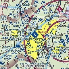
| Sectional chart |
|---|
|
CAUTION: Diagram may not be current
 Download PDF
of official airport diagram from the FAA
| Airport distance calculator |
|---|
|
|
| Sunrise and sunset |
|---|
|
Times for 04-Jun-2026
| | Local
(UTC-5) | | Zulu
(UTC) |
|---|
| Morning civil twilight | | 05:27 | | 10:27 |
| Sunrise | | 05:55 | | 10:55 |
| Sunset | | 20:03 | | 01:03 |
| Evening civil twilight | | 20:31 | | 01:31 |
|
| Current date and time |
|---|
| Zulu (UTC) | 04-Jun-2026 17:48:24 |
|---|
| Local (UTC-5) | 04-Jun-2026 12:48:24 |
|---|
|
| METAR |
|---|
| KHKS | 041653Z 15007KT 100V190 10SM CLR 28/18 A3015 RMK AO2 SLP200 T02780183
|
KJAN
7nm E | 041654Z 15008KT 10SM BKN250 28/19 A3015 RMK AO2 SLP203 T02780194
|
KMBO
9nm NE | 041735Z AUTO VRB03KT 10SM CLR 27/19 A3013 RMK AO2
|
KJVW
10nm W | 041735Z AUTO 13008G13KT 100V160 10SM CLR 29/20 A3012 RMK A01
|
|
| TAF |
|---|
| KHKS | 041120Z 0412/0512 11006KT P6SM FEW250
|
KJAN
7nm E | 041120Z 0412/0512 11007KT P6SM FEW250
|
|
| NOTAMs |
|---|
NOTAMs are issued by the DoD/FAA and will open in a separate window not controlled by AirNav.
|
|


