FAA INFORMATION EFFECTIVE 25 DECEMBER 2025
Location
| FAA Identifier: | HMT |
| Lat/Long: | 33-44-02.5000N 117-01-20.3000W
33-44.041667N 117-01.338333W
33.7340278,-117.0223056
(estimated) |
| Elevation: | 1514.8 ft. / 461.7 m (surveyed) |
| Variation: | 13E (1995) |
| From city: | 3 miles SW of HEMET, CA |
| Time zone: | UTC -8 (UTC -7 during Daylight Saving Time) |
| Zip code: | 92545 |
Airport Operations
| Airport use: | Open to the public |
| Activation date: | 03/1941 |
| Control tower: | no |
| ARTCC: | LOS ANGELES CENTER |
| FSS: | RIVERSIDE FLIGHT SERVICE STATION |
| NOTAMs facility: | RAL (NOTAM-D service available) |
| Attendance: | DAYLIGHT HOURS |
| Wind indicator: | lighted |
| Segmented circle: | yes |
| Lights: | ACTVT MIRL RY 05/23 & TWY LGTS - CTAF. |
| Beacon: | white-green (lighted land airport)
Operates sunset to sunrise. |
Airport Communications
| CTAF/UNICOM: | 123.0 |
| WX AWOS-3PT: | 118.375 (951-925-6886) |
| MARCH APPROACH: | 133.5 |
| MARCH DEPARTURE: | 133.5 |
| WX AWOS-3 at F70 (11 nm SW): | 119.025 (951-696-1018) |
| WX AWOS-3 at BNG (14 nm NE): | 134.625 (951-922-4674) |
- APCH/DEP CTL SVC PRVDD BY SOUTHERN CALIFORNIA TRACON (SCT) ON 134.0/278.3 WHEN (RIV) MARCH RAPCON CLSD.
Nearby radio navigation aids
| VOR radial/distance | | VOR name | | Freq | | Var |
|---|
| HDFr093/(8.5) | | HOMELAND VOR | | 112.05 | | 14E |
| RALr108/(25.1) | | RIVERSIDE VOR | | 108.60 | | 14E |
| PDZr099/27.6 | | PARADISE VORTAC | | 112.20 | | 15E |
| PSPr242/30.6 | | PALM SPRINGS VORTAC | | 115.50 | | 13E |
| ELBr070/35.5 | | EL TORO VOR/DME | | 117.20 | | 14E |
| OCNr019/35.6 | | OCEANSIDE VORTAC | | 115.30 | | 15E |
Airport Services
| Fuel available: | 100LL JET-A |
| Parking: | tiedowns |
| Airframe service: | MAJOR |
| Powerplant service: | MAJOR |
| Bottled oxygen: | NONE |
| Bulk oxygen: | NONE |
Runway Information
Runway 5/23
| Dimensions: | 4315 x 100 ft. / 1315 x 30 m |
| Surface: | asphalt, in good condition |
| Weight bearing capacity: | | Single wheel: | 80.0 | | Double wheel: | 130.0 |
|
| Runway edge lights: | medium intensity |
| RUNWAY 5 | | RUNWAY 23 |
| Latitude: | 33-43.844653N | | 33-44.168717N |
| Longitude: | 117-01.748282W | | 117-00.990322W |
| Elevation: | 1505.7 ft. | | 1514.7 ft. |
| Traffic pattern: | right | | left |
| Runway heading: | 050 magnetic, 063 true | | 230 magnetic, 243 true |
| Markings: | nonprecision, in good condition | | basic, in good condition |
| Visual slope indicator: | | | 2-light PAPI on left (3.00 degrees glide path) |
| Runway end identifier lights: | no | | no |
| Touchdown point: | yes, no lights | | yes, no lights |
Runway 4/22
| Dimensions: | 2014 x 25 ft. / 614 x 8 m |
| Surface: | asphalt, in fair condition |
| RUNWAY 4 | | RUNWAY 22 |
| Latitude: | 33-44.038502N | | 33-44.189503N |
| Longitude: | 117-01.447020W | | 117-01.093155W |
| Elevation: | 1506.6 ft. | | 1512.4 ft. |
| Traffic pattern: | left | | right |
| Runway heading: | 050 magnetic, 063 true | | 230 magnetic, 243 true |
| Markings: | basic, in fair condition | | basic, in good condition |
| Runway end identifier lights: | no | | no |
| Touchdown point: | yes, no lights | | yes, no lights |
Airport Ownership and Management from official FAA records
| Ownership: | Publicly-owned |
| Owner: | COUNTY OF RIVERSIDE
4080 LEMON STREET, 14TH FLOOR
RIVERSIDE, CA 92501
Phone 951-955-9722 |
| Manager: | ANGELA JAMISON
4080 LEMON STREET, 14TH FLOOR
RIVERSIDE, CA 92501
Phone 951-955-9418 |
Additional Remarks
| - | AIR TANKER ACTIVITY MAY-NOV; FOREST SVC FIRE FIGHTING ACFT FREQUENTLY FLY THE CONVENTIONAL RECTANGULAR PAT WITH FOUR 90 DEG CLEARING TURNS ENTERING THE DOWN WIND LEG ABEAM MIDPOINT OF RY. |
| - | WATCH FOR USFS FIRE FIGHTING ACFT. |
| - | GLIDER, ULTRALIGHT ACT NORTH SIDE OF ARPT. |
| - | FOR CD CTC SOCAL APCH AT 800-448-3724. |
Instrument Procedures
NOTE: All procedures below are presented as PDF files. If you need a reader for these files, you should download the free Adobe Reader.NOT FOR NAVIGATION. Please procure official charts for flight.
FAA instrument procedures published for use from 25 December 2025 at 0901z to 22 January 2026 at 0900z.
IAPs - Instrument Approach Procedures |
|---|
| RNAV (GPS) RWY 05 | |
download (272KB) |
| NOTE: Special Alternate Minimums apply | |
download (139KB) |
| NOTE: Special Take-Off Minimums/Departure Procedures apply | |
download (346KB) |
Other nearby airports with instrument procedures:
F70 - French Valley Airport (11 nm SW)
KRIV - March Air Reserve Base (15 nm NW)
KREI - Redlands Municipal Airport (22 nm N)
KSBD - San Bernardino International Airport (24 nm NW)
KRIR - Flabob Airport (25 nm NW)
|
|

Road maps at:
MapQuest
Bing
Google
| Aerial photo |
|---|
WARNING: Photo may not be current or correct
 Photo courtesy of www.photopilot.com
Photo taken 16-Mar-2021
Photo courtesy of www.photopilot.com
Photo taken 16-Mar-2021
Do you have a better or more recent aerial photo of Hemet-Ryan Airport that you would like to share? If so, please send us your photo.
|
| Sectional chart |
|---|
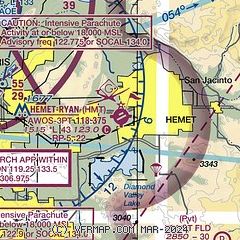
|
| Airport distance calculator |
|---|
|
|
| Sunrise and sunset |
|---|
|
Times for 29-Dec-2025
| | Local
(UTC-8) | | Zulu
(UTC) |
|---|
| Morning civil twilight | | 06:26 | | 14:26 |
| Sunrise | | 06:53 | | 14:53 |
| Sunset | | 16:47 | | 00:47 |
| Evening civil twilight | | 17:15 | | 01:15 |
|
| Current date and time |
|---|
| Zulu (UTC) | 29-Dec-2025 16:54:21 |
|---|
| Local (UTC-8) | 29-Dec-2025 08:54:21 |
|---|
|
| METAR |
|---|
| KHMT | 291635Z AUTO 00000KT 10SM CLR 06/01 A3021 RMK AO2
|
KF70
11nm SW | 291635Z AUTO 36005KT 10SM CLR 09/01 A3021 RMK AO2
|
KRIV
15nm NW | 291555Z AUTO 34004KT 10SM CLR 12/M05 A3018 RMK AO2 SLP220 T01231052
|
|
| TAF |
|---|
KRIV
15nm NW | 291200Z 2912/3018 35009KT 9999 FEW300 520009 QNH3014INS WND 290V030 TEMPO 2912/2917 02012G18KT BECMG 2917/2918 06010G15KT 9999 FEW300 520009 QNH3008INS WND 020V100 TEMPO 2917/3002 06015G25KT BECMG 3005/3006 06009KT 9999 SCT250 520009 QNH3011INS BECMG 3009/3010 04006KT 9999 SCT080 BKN150 BKN250 510006 QNH3015INS BECMG 3016/3017 06010G15KT 9999 SCT080 BKN150 BKN250 520009 QNH3017INS TEMPO 3017/3018 06015G25KT TX20/2921Z TN05/2914Z
|
|
| NOTAMs |
|---|
NOTAMs are issued by the DoD/FAA and will open in a separate window not controlled by AirNav.
|
|


