FAA INFORMATION EFFECTIVE 09 JULY 2026
Location
| FAA Identifier: | ICR |
| Lat/Long: | 43-23-22.1448N 099-50-28.3719W
43-23.369080N 099-50.472865W
43.3894847,-99.8412144
(estimated) |
| Elevation: | 2032.3 ft. / 619 m (estimated) |
| Variation: | 06E (2010) |
| From city: | 1 mile NE of WINNER, SD |
| Time zone: | UTC -5 (UTC -6 during Standard Time) |
| Zip code: | 57580 |
Airport Operations
| Airport use: | Open to the public |
| Control tower: | no |
| ARTCC: | MINNEAPOLIS CENTER |
| FSS: | HURON FLIGHT SERVICE STATION |
| NOTAMs facility: | ICR (NOTAM-D service available) |
| Attendance: | CONTINUOUS |
| Wind indicator: | lighted |
| Segmented circle: | yes |
| Lights: | ACTVT PAPI RY 13/31; MIRL RY 13/31 - CTAF. |
| Beacon: | white-green (lighted land airport)
Operates sunset to sunrise. |
Airport Communications
| CTAF/UNICOM: | 122.8 |
| WX ASOS: | 126.775 (605-569-5470) |
- APCH/DEP SVC PRVDD BY MINNEAPOLIS ARTCC (ZMP) ON FREQ 125.1/269.1 (PIERRE RCAG).
Airport Services
| Fuel available: | 100LL JET-A |
| Parking: | hangars and tiedowns |
| Airframe service: | MAJOR |
| Powerplant service: | MAJOR |
| Bottled oxygen: | NONE |
| Bulk oxygen: | NONE |
Runway Information
Runway 13/31
| Dimensions: | 5500 x 75 ft. / 1676 x 23 m |
| Surface: | concrete, in excellent condition |
| Weight bearing capacity: | | PCN 17 /R/B/W/T | | Single wheel: | 51.5 | | Double wheel: | 68.0 |
|
| Runway edge lights: | medium intensity |
| RUNWAY 13 | | RUNWAY 31 |
| Latitude: | 43-23.645673N | | 43-23.005113N |
| Longitude: | 099-50.836535W | | 099-49.959410W |
| Elevation: | 2011.4 ft. | | 2024.7 ft. |
| Traffic pattern: | left | | left |
| Runway heading: | 129 magnetic, 135 true | | 309 magnetic, 315 true |
| Markings: | nonprecision, in good condition | | nonprecision, in good condition |
| Visual slope indicator: | 2-light PAPI on left (3.00 degrees glide path) | | 2-light PAPI on left (3.00 degrees glide path) |
| Runway end identifier lights: | no | | no |
| Touchdown point: | yes, no lights | | yes, no lights |
Runway 3/21
| Dimensions: | 2751 x 150 ft. / 839 x 46 m |
| Surface: | turf, in good condition |
| Runway edge markings: | RWY 03/21 MARKED WITH BLACK AND WHITE CONES. |
| Operational restrictions: | CLSD WINTER MONTHS. |
| RUNWAY 3 | | RUNWAY 21 |
| Latitude: | 43-23.276593N | | 43-23.636247N |
| Longitude: | 099-50.811238W | | 099-50.433957W |
| Elevation: | 2032.3 ft. | | 2002.4 ft. |
| Traffic pattern: | left | | left |
| Runway heading: | 032 magnetic, 038 true | | 212 magnetic, 218 true |
| Runway end identifier lights: | no | | no |
| Touchdown point: | yes, no lights | | yes, no lights |
| Obstructions: | none | | 5 ft. fence, 100 ft. from runway, 20:1 slope to clear |
Airport Ownership and Management from official FAA records
| Ownership: | Publicly-owned |
| Owner: | CITY OF WINNER
PO BOX 691
WINNER, SD 57580
Phone 605-842-2606 |
| Manager: | TESSA HOWARD
RR 2 BOX 100
WINNER, SD 57580
Phone 605-999-3868
ALT MGR PH CELL 605-999-3868. |
Additional Remarks
| - | HIGH AIR TFC OCT-NOV. |
| - | GCO AVBL ON FREQ 121.725 (4 CLICKS TO MINNEAPOLIS CENTER) |
| - | FOR CD IF UNA VIA GCO CTC MINNEAPOLIS ARTCC AT 651-463-5588. |
Instrument Procedures
NOTE: All procedures below are presented as PDF files. If you need a reader for these files, you should download the free Adobe Reader.NOT FOR NAVIGATION. Please procure official charts for flight.
FAA instrument procedures published for use from 09 July 2026 at 0901Z to 06 August 2026 at 0900Z.
IAPs - Instrument Approach Procedures |
|---|
| RNAV (GPS) RWY 13 | |
download (250KB) |
| RNAV (GPS) RWY 31 | |
download (223KB) |
| NOTE: Special Alternate Minimums apply | |
download (157KB) |
| NOTE: Special Take-Off Minimums/Departure Procedures apply | |
download (237KB) |
Other nearby airports with instrument procedures:
9D1 - Gregory Municipal Airport/Flynn Field (22 nm SE)
9V9 - Chamberlain Municipal Airport (32 nm NE)
KVTN - Miller Field Airport (45 nm SW)
KSUO - Rosebud Sioux Tribal Airport (45 nm W)
KANW - Ainsworth Regional Airport (49 nm S)
|
|

Road maps at:
MapQuest
Bing
Google
| Aerial photo |
|---|
WARNING: Photo may not be current or correct
 Photo by Steve Hamilton
Photo taken 29-Oct-2008
Photo by Steve Hamilton
Photo taken 29-Oct-2008
Do you have a better or more recent aerial photo of Winner Regional Airport that you would like to share? If so, please send us your photo.
|
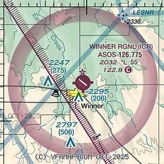
| Sectional chart |
|---|
|
| Airport distance calculator |
|---|
|
|
| Sunrise and sunset |
|---|
|
Times for 15-Jul-2026
| | Local
(UTC-5) | | Zulu
(UTC) |
|---|
| Morning civil twilight | | 05:39 | | 10:39 |
| Sunrise | | 06:14 | | 11:14 |
| Sunset | | 21:17 | | 02:17 |
| Evening civil twilight | | 21:51 | | 02:51 |
|
| Current date and time |
|---|
| Zulu (UTC) | 15-Jul-2026 06:15:00 |
|---|
| Local (UTC-5) | 15-Jul-2026 01:15:00 |
|---|
|
| METAR |
|---|
| KICR | 150553Z AUTO 16012KT 10SM CLR 24/17 A3013 RMK AO2 SLP183 T02390167 10339 20233 403610211 51007
|
|
| TAF |
|---|
KVTN
44nm SW | 141735Z 1418/1518 16012G20KT P6SM SKC FM150200 15010KT P6SM SKC FM151400 18012G19KT P6SM FEW050
|
|
| NOTAMs |
|---|
NOTAMs are issued by the DoD/FAA and will open in a separate window not controlled by AirNav.
|
|

