FAA INFORMATION EFFECTIVE 14 MAY 2026
Location
| FAA Identifier: | IYK |
| Lat/Long: | 35-39-31.4686N 117-49-46.3170W
35-39.524477N 117-49.771950W
35.6587413,-117.8295325
(estimated) |
| Elevation: | 2457 ft. / 748.9 m (surveyed) |
| Variation: | 14E (1985) |
| From city: | 1 mile NW of INYOKERN, CA |
| Time zone: | UTC -7 (UTC -8 during Standard Time) |
| Zip code: | 93527 |
Airport Operations
| Airport use: | Open to the public |
| Activation date: | 04/1940 |
| Control tower: | no |
| ARTCC: | LOS ANGELES CENTER |
| FSS: | RIVERSIDE FLIGHT SERVICE STATION |
| NOTAMs facility: | IYK (NOTAM-D service available) |
| Attendance: | MON-FRI 0730-1600 |
| Wind indicator: | lighted |
| Segmented circle: | yes |
| Lights: | ACTVT VASI RWY 20; MIRL RWYS 02/20, 10/28, 15/33 - CTAF. PAPI RWYS 02, 15 & 33 OPR CONSLY. |
| Beacon: | white-green (lighted land airport)
Operates sunset to sunrise. |
Airport Communications
| CTAF/UNICOM: | 122.8 |
| JOSHUA APPROACH: | 133.65 |
| JOSHUA DEPARTURE: | 133.65 |
- AUTOMATED UNICOM - 3 CLICKS FOR ARPT ADVISORY & WEATHER OR DIAL 617-262-3825, 4 CLICKS FOR RADIO CHECK.
Airport Services
| Fuel available: | 100LL JET-A
100LL:AFTER 1600 CALLOUT FEE FOR SVC CALL (760) 382-3383. |
| Parking: | hangars and tiedowns |
| Airframe service: | MINOR |
| Powerplant service: | MINOR |
Runway Information
Runway 15/33
| Dimensions: | 7100 x 75 ft. / 2164 x 23 m |
| Surface: | asphalt, in fair condition
PAVEMENT EXPERIENCING LONGL AND LATERAL BLOCK CRACKING ON PTNS OF RWY. |
| Weight bearing capacity: | | PCN 7 /F/C/Y/U | | Single wheel: | 24.0 |
|
| Runway edge lights: | medium intensity |
| RUNWAY 15 | | RUNWAY 33 |
| Latitude: | 35-40.023667N | | 35-38.889000N |
| Longitude: | 117-50.057833W | | 117-49.707667W |
| Elevation: | 2454.9 ft. | | 2428.8 ft. |
| Traffic pattern: | left | | left |
| Runway heading: | 152 magnetic, 166 true | | 332 magnetic, 346 true |
| Markings: | basic, in good condition | | basic, in good condition |
| Visual slope indicator: | 2-light PAPI on left (3.00 degrees glide path) | | 2-light PAPI on left (3.30 degrees glide path) |
| Runway end identifier lights: | no | | no |
| Touchdown point: | yes, no lights | | yes, no lights |
Runway 2/20
| Dimensions: | 6275 x 75 ft. / 1913 x 23 m |
| Surface: | asphalt, in good condition |
| Weight bearing capacity: | | PCN 6 /F/C/X/U | | Single wheel: | 30.0 | | Double wheel: | 50.0 | | Double tandem: | 80.0 |
|
| Runway edge lights: | medium intensity |
| RUNWAY 2 | | RUNWAY 20 |
| Latitude: | 35-38.896000N | | 35-39.783667N |
| Longitude: | 117-50.002167W | | 117-49.352000W |
| Elevation: | 2441.6 ft. | | 2413.7 ft. |
| Traffic pattern: | left | | right |
| Runway heading: | 017 magnetic, 031 true | | 197 magnetic, 211 true |
| Displaced threshold: | no | | 320 ft. |
| Markings: | nonprecision, in good condition | | nonprecision, in good condition |
| Visual slope indicator: | 2-light PAPI on left (3.30 degrees glide path) | | 4-box VASI on left (3.00 degrees glide path) |
| Runway end identifier lights: | no | | no |
| Touchdown point: | yes, no lights | | yes, no lights |
Runway 10/28
| Dimensions: | 4150 x 75 ft. / 1265 x 23 m |
| Surface: | asphalt, in poor condition
POOR BUT STABLE. PTNS OF RWY CTRLN MARKING OBSCD BY CRACK FILLER. |
| Weight bearing capacity: | | PCN 7 /F/C/Y/U | | Single wheel: | 24.0 |
|
| Runway edge lights: | medium intensity |
| RUNWAY 10 | | RUNWAY 28 |
| Latitude: | 35-40.067000N | | 35-39.773500N |
| Longitude: | 117-50.104667W | | 117-49.347000W |
| Elevation: | 2456.7 ft. | | 2413.3 ft. |
| Traffic pattern: | left | | left |
| Runway heading: | 101 magnetic, 115 true | | 281 magnetic, 295 true |
| Displaced threshold: | no | | 103 ft. |
| Markings: | numbers only, in fair condition | | numbers only, in fair condition |
| Runway end identifier lights: | no | | no |
| Touchdown point: | yes, no lights | | yes, no lights |
Airport Ownership and Management from official FAA records
| Ownership: | Publicly-owned |
| Owner: | INDIAN WELLS VALLEY APT DIST
P.O. BOX 634
INYOKERN, CA 93527
Phone 760-377-5844 |
| Manager: | SCOTT A. SEYMOUR
1669 AIRPORT ROAD
INYOKERN, CA 93527
Phone 760-377-5844
AIRPORT DIRECTOR. EMAIL: SCOTT@INYOKERNAIRPORT.COM |
Additional Remarks
| - | RY 02/20 & 15/33 HAVE DSTC RMNG SIGNS. |
| - | FREQUENT GLIDER OPNS ON WEEKENDS. |
| - | FOR CD CTC LOS ANGELES ARTCC AT 661-575-2079. |
Instrument Procedures
NOTE: All procedures below are presented as PDF files. If you need a reader for these files, you should download the free Adobe Reader.NOT FOR NAVIGATION. Please procure official charts for flight.
FAA instrument procedures published for use from 14 May 2026 at 0901Z to 11 June 2026 at 0900Z.
IAPs - Instrument Approach Procedures |
|---|
| RNAV (GPS) RWY 02 | |
download (379KB) |
Departure Procedures |
|---|
| INYOKERN TWO | |
download (107KB) |
|
|---|
| LAKE HUGHES TWO (OBSTACLE) (RNAV) | |
download (126KB) |
| NOTE: Special Take-Off Minimums/Departure Procedures apply | |
download (132KB) |
Other nearby airports with instrument procedures:
KNID - China Lake Naval Air Weapons Station (Armitage Field) (7 nm E)
L71 - California City Municipal Airport (32 nm S)
KMHV - Mojave Air & Space Port/Rutan Field (39 nm SW)
KEDW - Edwards Air Force Base (45 nm S)
KWJF - General Wm J Fox Airfield (58 nm S)
|
|

Road maps at:
MapQuest
Bing
Google
| Aerial photo |
|---|
WARNING: Photo may not be current or correct
 Photo by Tom Bozack, with Dan Kline piloting
Taken early April 2006
Photo by Tom Bozack, with Dan Kline piloting
Taken early April 2006
Do you have a better or more recent aerial photo of Inyokern Airport that you would like to share? If so, please send us your photo.
|
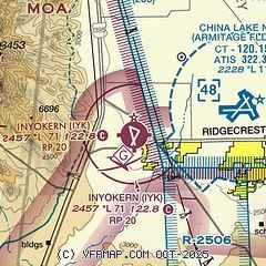
| Sectional chart |
|---|
|
| Airport distance calculator |
|---|
|
|
| Sunrise and sunset |
|---|
|
Times for 06-Jun-2026
| | Local
(UTC-7) | | Zulu
(UTC) |
|---|
| Morning civil twilight | | 05:07 | | 12:07 |
| Sunrise | | 05:36 | | 12:36 |
| Sunset | | 20:03 | | 03:03 |
| Evening civil twilight | | 20:33 | | 03:33 |
|
| Current date and time |
|---|
| Zulu (UTC) | 06-Jun-2026 08:43:40 |
|---|
| Local (UTC-7) | 06-Jun-2026 01:43:40 |
|---|
|
| METAR |
|---|
KNID
8nm E | 060656Z AUTO 20010KT 10SM CLR 27/M01 A2973 RMK AO2 SLP040 T02721006 $
|
|
| NOTAMs |
|---|
NOTAMs are issued by the DoD/FAA and will open in a separate window not controlled by AirNav.
|
|

