FAA INFORMATION EFFECTIVE 27 NOVEMBER 2025
Location
| FAA Identifier: | JWN |
| Lat/Long: | 36-10-58.8786N 086-53-11.3832W
36-10.981310N 086-53.189720W
36.1830218,-86.8864953
(estimated) |
| Elevation: | 501 ft. / 152.7 m (surveyed) |
| Variation: | 03W (2010) |
| From city: | 1 mile NW of NASHVILLE, TN |
| Time zone: | UTC -6 (UTC -5 during Daylight Saving Time) |
| Zip code: | 37209 |
Airport Operations
| Airport use: | Open to the public |
| Activation date: | 07/1986 |
| Control tower: | yes |
| ARTCC: | MEMPHIS CENTER |
| FSS: | NASHVILLE FLIGHT SERVICE STATION |
| NOTAMs facility: | BNA (NOTAM-D service available) |
| Attendance: | CONTINUOUS |
| Wind indicator: | lighted |
| Segmented circle: | yes |
| Lights: | WHEN ATCT CLSD ACTVT REIL RWY 02 & 20; PAPI RWY 02 & 20; MIRL RWY 02/20 - CTAF. |
| Beacon: | white-green (lighted land airport)
Operates sunset to sunrise. |
Airport Communications
| CTAF: | 119.45 |
| UNICOM: | 122.7 |
| ATIS: | 127.075 |
| WX AWOS-3: | PHONE 615-350-6222 |
| JOHN TUNE GROUND: | 121.7 [0700-2100] |
| JOHN TUNE TOWER: | 119.45 [0700-2100] |
| NASHVILLE APPROACH: | 119.35 |
| NASHVILLE DEPARTURE: | 119.35 |
| CLEARANCE DELIVERY: | 121.7 124.55 ;WHEN TWR CLSD |
| WX ASOS at BNA (11 nm E): | PHONE 629-236-5115 |
Nearby radio navigation aids
| VOR radial/distance | | VOR name | | Freq | | Var |
|---|
| BNAr288/10.2 | | NASHVILLE VORTAC | | 114.10 | | 02W |
| CKVr137/36.6 | | CLARKSVILLE VOR/DME | | 110.60 | | 01W |
Airport Services
| Fuel available: | 100LL JET-A+ |
| Parking: | hangars and tiedowns |
| Airframe service: | MAJOR |
| Powerplant service: | MAJOR |
| Bottled oxygen: | HIGH |
| Bulk oxygen: | LOW |
Runway Information
Runway 2/20
| Dimensions: | 6001 x 100 ft. / 1829 x 30 m |
| Surface: | asphalt/grooved, in good condition |
| Weight bearing capacity: | | Single wheel: | 35.0 | | Double wheel: | 97.0 |
|
| Runway edge lights: | medium intensity |
| RUNWAY 2 | | RUNWAY 20 |
| Latitude: | 36-10.503127N | | 36-11.459447N |
| Longitude: | 086-53.345162W | | 086-53.034330W |
| Elevation: | 458.6 ft. | | 501.0 ft. |
| Traffic pattern: | left | | right |
| Runway heading: | 018 magnetic, 015 true | | 198 magnetic, 195 true |
| Declared distances: | TORA:6001 TODA:6001 ASDA:6001 LDA:6001 | | TORA:6001 TODA:6001 ASDA:6001 LDA:6001 |
| Markings: | nonprecision, in good condition | | precision, in good condition |
| Visual slope indicator: | 4-light PAPI on left (3.00 degrees glide path) | | 4-light PAPI on left (3.00 degrees glide path) |
| Runway end identifier lights: | yes | | yes |
| Touchdown point: | yes, no lights | | yes, no lights |
| Instrument approach: | | | ILS/DME |
| Obstructions: | 49 ft. tree, 1545 ft. from runway, 348 ft. right of centerline, 27:1 slope to clear | | 63 ft. tree, 2166 ft. from runway, 440 ft. right of centerline, 31:1 slope to clear |
Airport Ownership and Management from official FAA records
| Ownership: | Publicly-owned |
| Owner: | METRO NASHVILLE APT AUTHORITY
ONE TERMINAL DR.
NASHVILLE, TN 37214
Phone 615-275-1600 |
| Manager: | ADAM C. WOLF
1000 TUNE AIRPORT DRIVE
NASHVILLE, TN 37209
Phone 615-275-1783 |
Additional Remarks
| E60-20 | ENGINEERED MATERIAL ARRESTING SYSTEM (EMAS) 186 FT LONG BY 121 FT WIDE LCTD 560 FT FM DEP END RWY 20. |
| - | BIRDS & DEER INVOF ARPT. |
| - | BLEEDOVER OCR ALL FREQS 1.75 NM NORTH OF RWY. |
| - | WHEN ATCT CLSD FOR CD CTC NASHVILLE APCH ON 124.55, IF UNABLE CALL 615-695-4524. |
| - | TWY R1 CLSD TO ACFT WINGSPAN MORE THAN 49FT |
| - | TWY R2 CLSD TO ACFT WINGSPAN MORE THAN 79FT |
Instrument Procedures
NOTE: All procedures below are presented as PDF files. If you need a reader for these files, you should download the free Adobe Reader.NOT FOR NAVIGATION. Please procure official charts for flight.
FAA instrument procedures published for use from 27 November 2025 at 0901Z to 25 December 2025 at 0900Z.
IAPs - Instrument Approach Procedures |
|---|
| ILS OR LOC RWY 20 | |
download (242KB) |
| RNAV (GPS) RWY 02 | |
download (221KB) |
| RNAV (GPS) RWY 20 | |
download (274KB) |
Departure Procedures |
|---|
| JOHN TUNE ONE | |
download (134KB) |
| NOTE: Special Take-Off Minimums/Departure Procedures apply | |
download (188KB) |
Other nearby airports with instrument procedures:
KBNA - Nashville International Airport (11 nm E)
KMQY - Smyrna Airport (21 nm SE)
M91 - Springfield Robertson County Airport (21 nm N)
KXNX - Music City Executive Airport (26 nm NE)
M02 - Dickson Municipal Airport (27 nm W)
|
|

Road maps at:
MapQuest
Bing
Google
| Aerial photo |
|---|
WARNING: Photo may not be current or correct
 Photo by Shawn Everingham
Photo taken 10-Jun-2017
looking southwest.
Photo by Shawn Everingham
Photo taken 10-Jun-2017
looking southwest.
Do you have a better or more recent aerial photo of John C Tune Airport that you would like to share? If so, please send us your photo.
|
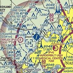
| Sectional chart |
|---|
|
CAUTION: Diagram may not be current

| Airport distance calculator |
|---|
|
|
| Sunrise and sunset |
|---|
|
Times for 11-Dec-2025
| | Local
(UTC-6) | | Zulu
(UTC) |
|---|
| Morning civil twilight | | 06:21 | | 12:21 |
| Sunrise | | 06:50 | | 12:50 |
| Sunset | | 16:32 | | 22:32 |
| Evening civil twilight | | 17:01 | | 23:01 |
|
| Current date and time |
|---|
| Zulu (UTC) | 12-Dec-2025 05:48:34 |
|---|
| Local (UTC-6) | 11-Dec-2025 23:48:34 |
|---|
|
| METAR |
|---|
| KJWN | 120535Z AUTO 07006KT 8SM CLR 04/M03 A2999 RMK AO2
|
KBNA
11nm E | 120453Z 11006KT 10SM OVC150 04/M03 A3001 RMK AO2 SLP165 T00441033 $
|
|
| TAF |
|---|
KBNA
11nm E | 112055Z 1121/1218 20004KT P6SM BKN100 FM120900 16006KT P6SM OVC100 WS020/25040KT FM121500 25010G15KT P6SM SCT250
|
|
| NOTAMs |
|---|
NOTAMs are issued by the DoD/FAA and will open in a separate window not controlled by AirNav.
|
|


