FAA INFORMATION EFFECTIVE 25 DECEMBER 2025
Location
| FAA Identifier: | LRO |
| Lat/Long: | 32-53-52.2000N 079-46-58.3000W
32-53.870000N 079-46.971667W
32.8978333,-79.7828611
(estimated) |
| Elevation: | 11.6 ft. / 3.5 m (surveyed) |
| Variation: | 07W (2010) |
| From city: | 9 miles NE of MOUNT PLEASANT, SC |
| Time zone: | UTC -5 (UTC -4 during Daylight Saving Time) |
| Zip code: | 29464 |
Airport Operations
| Airport use: | Open to the public |
| Activation date: | 07/1986 |
| Control tower: | no |
| ARTCC: | JACKSONVILLE CENTER |
| FSS: | ANDERSON FLIGHT SERVICE STATION |
| NOTAMs facility: | AND (NOTAM-D service available) |
| Attendance: | 0600-2000 |
| Pattern altitude: | 999.6 ft. MSL
TPA: 988 FT AGL. |
| Wind indicator: | lighted |
| Segmented circle: | yes |
| Lights: | ACTVT PAPI RWY 17 & 35; MIRL RWY 17/35 - CTAF. |
| Beacon: | white-green (lighted land airport)
Operates sunset to sunrise. |
Airport Communications
| CTAF/UNICOM: | 122.7 |
| WX AWOS-3: | 118.625 (843-849-0438) |
| CHARLESTON APPROACH: | 121.275 |
| CHARLESTON DEPARTURE: | 121.275 |
| WX AWOS-1 at SC80 (11 nm SW): | 122.975 (843-985-0983) |
| WX ASOS at CHS (13 nm W): | PHONE 843-214-2525 |
| WX AWOS-3 at JZI (16 nm SW): | 123.775 (843-559-3123) |
Nearby radio navigation aids
| VOR radial/distance | | VOR name | | Freq | | Var |
|---|
| CHSr094/12.8 | | CHARLESTON VORTAC | | 113.50 | | 05W |
Airport Services
| Fuel available: | 100LL JET-A |
| Parking: | tiedowns |
| Airframe service: | MINOR |
| Powerplant service: | MINOR |
Runway Information
Runway 17/35
| Dimensions: | 3700 x 75 ft. / 1128 x 23 m |
| Surface: | asphalt, in good condition |
| Weight bearing capacity: | |
| Runway edge lights: | medium intensity |
| RUNWAY 17 | | RUNWAY 35 |
| Latitude: | 32-54.167435N | | 32-53.573058N |
| Longitude: | 079-47.052942W | | 079-46.890215W |
| Elevation: | 11.3 ft. | | 11.3 ft. |
| Traffic pattern: | left | | right |
| Runway heading: | 174 magnetic, 167 true | | 354 magnetic, 347 true |
| Markings: | nonprecision, in good condition | | nonprecision, in good condition |
| Visual slope indicator: | 4-light PAPI on left (4.00 degrees glide path) | | 4-light PAPI on left (4.00 degrees glide path) |
| Touchdown point: | yes, no lights | | yes, no lights |
Airport Ownership and Management from official FAA records
| Ownership: | Publicly-owned |
| Owner: | CHARLESTON CO AVIATION AUTHORITY
5500 INTERNATIONAL BLVD, #101
CHARLESTON, SC 29418-6911
Phone 843-767-7000 |
| Manager: | ELLIOTT SUMMEY
CHARLESTON CO AVIATION AUTHORITY, 5500 INTERNATIONAL BLVD, #101
CHARLESTON, SC 29418-6911
Phone 843-767-7000 |
Additional Remarks
| - | TWO 2000 FT TOWERS APPROX 4-6 MILES EAST OF ARPT. |
| - | DEER & BIRDS ON & INVOF ARPT. |
| - | FOR CD CTC CHARLESTON APCH AT 843-414-2832. |
| - | TXG ON THE FNT LINE OF THE FBO RAMP, IN FNT OF THE TRML, WILL BE RSTRD TO ACFT WITH A WINGSPAN LESS THAN 38 FT. NO ACFT, WITH A WINGSPAN THAT EXCEEDS 38 FT, IS PMTD TO PARK ON THE FNT LINE OF THE FBO RAMP OR TAX THROUGH THE FNT TAXILANE IN FNT OF THE TRML AS IT EXCEEDS SAFETY LIMITS AND WING TIP CLEARANCES. ACFT WITH WINGSPANS EXCEEDING 38 FT MUST CTC THE ARPT FBO IN ADVANCE AT 843-884-8837 FOR PRKG AND CDN PRIOR TO ARR AND MUST TAX THROUGH THE CNTR AND OUT TAXILANES OF THE FBO RAMP. |
Instrument Procedures
NOTE: All procedures below are presented as PDF files. If you need a reader for these files, you should download the free Adobe Reader.NOT FOR NAVIGATION. Please procure official charts for flight.
FAA instrument procedures published for use from 25 December 2025 at 0901z to 22 January 2026 at 0900z.
IAPs - Instrument Approach Procedures |
|---|
| RNAV (GPS) RWY 17 | |
download (257KB) |
| RNAV (GPS) RWY 35 | |
download (245KB) |
| VOR/DME-A | |
download (254KB) |
| NOTE: Special Alternate Minimums apply | |
download (162KB) |
| NOTE: Special Take-Off Minimums/Departure Procedures apply | |
download (356KB) |
Other nearby airports with instrument procedures:
KCHS - Charleston Air Force Base/International Airport (13 nm W)
KJZI - Charleston Executive Airport (16 nm SW)
KMKS - Berkeley County Airport (21 nm NW)
KDYB - Summerville Airport (27 nm W)
KGGE - Georgetown County Airport (34 nm NE)
|
|

Road maps at:
MapQuest
Bing
Google
| Aerial photo |
|---|
WARNING: Photo may not be current or correct
 Photo courtesy of CCAA (Charleston County Aviation Authority)
Taken in October 2017
looking south-southeast.
Photo courtesy of CCAA (Charleston County Aviation Authority)
Taken in October 2017
looking south-southeast.
Do you have a better or more recent aerial photo of Mount Pleasant Regional Airport-Faison Field that you would like to share? If so, please send us your photo.
|
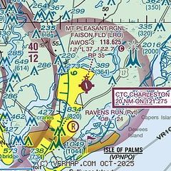
| Sectional chart |
|---|
|
| Airport distance calculator |
|---|
|
|
| Sunrise and sunset |
|---|
|
Times for 15-Jan-2026
| | Local
(UTC-5) | | Zulu
(UTC) |
|---|
| Morning civil twilight | | 06:56 | | 11:56 |
| Sunrise | | 07:23 | | 12:23 |
| Sunset | | 17:34 | | 22:34 |
| Evening civil twilight | | 18:01 | | 23:01 |
|
| Current date and time |
|---|
| Zulu (UTC) | 16-Jan-2026 04:34:13 |
|---|
| Local (UTC-5) | 15-Jan-2026 23:34:13 |
|---|
|
| METAR |
|---|
| KLRO | 160415Z AUTO 29008KT 10SM CLR 01/M13 A3004 RMK AO2
|
KCHS
13nm W | 160356Z 30008KT 10SM FEW040 01/M13 A3004 RMK AO2 SLP172 T00111133
|
KJZI
16nm SW | 160415Z AUTO 28007KT 10SM CLR 01/M14 A3006 RMK AO2
|
|
| TAF |
|---|
KCHS
13nm W | 151720Z 1518/1618 31013G25KT P6SM SKC FM160200 31005G20KT P6SM SKC FM161200 22004KT P6SM SKC
|
KJZI
16nm SW | 151720Z 1518/1618 31016G23KT P6SM SKC FM160200 31005G20KT P6SM SKC FM161200 22004KT P6SM SKC
|
|
| NOTAMs |
|---|
NOTAMs are issued by the DoD/FAA and will open in a separate window not controlled by AirNav.
|
|

