FAA INFORMATION EFFECTIVE 09 JULY 2026
Location
| FAA Identifier: | LVM |
| Lat/Long: | 45-41-57.9000N 110-26-52.9000W
45-41.965000N 110-26.881667W
45.6994167,-110.4480278
(estimated) |
| Elevation: | 4659.4 ft. / 1420.2 m (surveyed) |
| Variation: | 15E (1990) |
| From city: | 5 miles E of LIVINGSTON, MT |
| Time zone: | UTC -6 (UTC -7 during Standard Time) |
| Zip code: | 59047 |
Airport Operations
| Airport use: | Open to the public |
| Activation date: | 03/1943 |
| Control tower: | no |
| ARTCC: | SALT LAKE CITY CENTER |
| FSS: | GREAT FALLS FLIGHT SERVICE STATION |
| NOTAMs facility: | LVM (NOTAM-D service available) |
| Attendance: | 0800-1700 |
| Wind indicator: | lighted |
| Segmented circle: | no |
| Lights: | ACTIVATE MIRL RWY 04/22 - 123.0. |
| Beacon: | white-green (lighted land airport)
Operates sunset to sunrise. |
| Landing fee: | yes, LDG FEE FOR ACFT OVR 12500 LBS. |
Airport Communications
| CTAF/UNICOM: | 123.0 |
| WX ASOS: | 135.275 (406-222-2338) |
| BIG SKY APPROACH: | 119.55 |
| BIG SKY DEPARTURE: | 119.55 |
- COMMUNICATIONS PRVDD BY GREAT FALLS RADIO ON FREQ 122.2 (LIVINGSTON RCO).
- APCH/DEP CTL SVC PRVDD BY SALT LAKE ARTCC (ZLC) ON FREQS 119.550/235.775 (LIVINGSTON A RCAG) WHEN BIG SKY APCH CTL (BOI) IS UNAVAILABLE 0715-1300Z++.
Nearby radio navigation aids
| VOR radial/distance | | VOR name | | Freq | | Var |
|---|
| LVM at field | | LIVINGSTON VOR/DME | | 116.10 | | 15E |
| BZNr082/30.1 | | BOZEMAN VOR/DME | | 112.40 | | 18E |
Airport Services
| Fuel available: | 100LL JET-A
A:WKENDS AND AFT HRS CALL 406-222-6504. |
| Parking: | hangars and tiedowns |
| Airframe service: | NONE |
| Powerplant service: | NONE |
| Bottled oxygen: | NONE |
| Bulk oxygen: | NONE |
Runway Information
Runway 4/22
| Dimensions: | 5701 x 75 ft. / 1738 x 23 m |
| Surface: | asphalt, in excellent condition |
| Weight bearing capacity: | | PCN 24 /F/A/Y/U | | Single wheel: | 75.0 | | Double wheel: | 99.9 |
|
| Runway edge lights: | medium intensity |
| RUNWAY 4 | | RUNWAY 22 |
| Latitude: | 45-41.599323N | | 45-42.142063N |
| Longitude: | 110-27.304547W | | 110-26.212900W |
| Elevation: | 4649.6 ft. | | 4646.3 ft. |
| Traffic pattern: | left | | left |
| Runway heading: | 039 magnetic, 054 true | | 219 magnetic, 234 true |
| Markings: | nonprecision, in good condition | | nonprecision, in good condition |
| Visual slope indicator: | | | 4-light PAPI on left (3.00 degrees glide path)
PAPI UNUSBL BYD 5 DEGS RIGHT OF CNTRLN. |
| Runway end identifier lights: | | | yes |
| Touchdown point: | yes, no lights | | yes, no lights |
Runway 8/26
| Dimensions: | 3762 x 125 ft. / 1147 x 38 m |
| Surface: | turf, in good condition
MOWING IREG. |
| Runway edge markings: | RWYS 08 & 26 THLDS & FIRST 200 FT MKD WITH W CONES. |
| RUNWAY 8 | | RUNWAY 26 |
| Latitude: | 45-42.091507N | | 45-42.060165N |
| Longitude: | 110-27.380895W | | 110-26.498805W |
| Elevation: | 4658.6 ft. | | 4650.2 ft. |
| Traffic pattern: | left | | left |
| Runway heading: | 078 magnetic, 093 true | | 258 magnetic, 273 true |
| Markings: | , in good condition | | , in good condition |
| Touchdown point: | yes, no lights | | yes, no lights |
Runway 13/31
| Dimensions: | 2724 x 120 ft. / 830 x 37 m |
| Surface: | turf, in good condition
MOWING IREG. |
| Runway edge markings: | RWYS 13 & 31 THLDS & FIRST 200 FT MKD WITH W CONES. |
| RUNWAY 13 | | RUNWAY 31 |
| Latitude: | 45-42.198910N | | 45-41.823640N |
| Longitude: | 110-27.234202W | | 110-26.884717W |
| Elevation: | 4659.4 ft. | | 4651.5 ft. |
| Traffic pattern: | left | | left |
| Runway heading: | 132 magnetic, 147 true | | 312 magnetic, 327 true |
| Markings: | , in good condition | | , in good condition |
| Touchdown point: | yes, no lights | | yes, no lights |
Airport Ownership and Management from official FAA records
| Ownership: | Publicly-owned |
| Owner: | LIVINGSTON CITY PARK CO
COUNTY BLDG, 414 E CALLENDER
LIVINGSTON, MT 59047
Phone 406-222-4106 |
| Manager: | KELLY HANCOCK
COUNTY BLDG, 414 E CALLENDER
LIVINGSTON, MT 59047
Phone 406-223-2391 |
Additional Remarks
| - | RWY 31 MTN 1 MILE AT 23:1 RATIO. |
| - | WILDLIFE ON & INVOF ARPT. |
| - | AG OPS APR THROUGH SEP. |
| - | FOR CD IF UNA TO CTC ON FSS FREQ, CTC SALT LAKE ARTCC AT 801-320-2568. |
| - | COLD TEMPERATURE AIRPORT. ALTITUDE CORRECTION REQUIRED AT OR BELOW -28C. |
| - | PAPI RWY 22 OPR CONSLY. |
| - | AIRFIELD SFC COND UNMONITORED 1700-0800. |
Instrument Procedures
NOTE: All procedures below are presented as PDF files. If you need a reader for these files, you should download the free Adobe Reader.NOT FOR NAVIGATION. Please procure official charts for flight.
FAA instrument procedures published for use from 09 July 2026 at 0901Z to 06 August 2026 at 0900Z.
IAPs - Instrument Approach Procedures |
|---|
| RNAV (GPS) RWY 22 | |
download (297KB) |
| VOR/DME-B | |
download (320KB) |
| NOTE: Special Alternate Minimums apply | |
download (185KB) |
|
|---|
| LIVINGSTON TWO (OBSTACLE) | |
download (322KB) |
| NOTE: Special Take-Off Minimums/Departure Procedures apply | |
download (530KB) |
Other nearby airports with instrument procedures:
6S0 - Big Timber at Howard Field Airport (21 nm E)
KBZN - Bozeman Yellowstone International Airport (30 nm W)
KHWQ - Wheatland County Airport at Harlowton (51 nm NE)
7S6 - White Sulphur Springs Airport (52 nm N)
KEKS - Ennis - Big Sky Airport (57 nm SW)
|
|

Road maps at:
MapQuest
Bing
Google
| Aerial photo |
|---|
WARNING: Photo may not be current or correct

Do you have a better or more recent aerial photo of Mission Field Airport that you would like to share? If so, please send us your photo.
|
| Sectional chart |
|---|
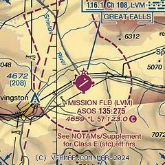
|
CAUTION: Diagram may not be current

| Airport distance calculator |
|---|
|
|
| Sunrise and sunset |
|---|
|
Times for 23-Jul-2026
| | Local
(UTC-6) | | Zulu
(UTC) |
|---|
| Morning civil twilight | | 05:20 | | 11:20 |
| Sunrise | | 05:56 | | 11:56 |
| Sunset | | 21:00 | | 03:00 |
| Evening civil twilight | | 21:36 | | 03:36 |
|
| Current date and time |
|---|
| Zulu (UTC) | 23-Jul-2026 09:23:42 |
|---|
| Local (UTC-6) | 23-Jul-2026 03:23:42 |
|---|
|
| METAR |
|---|
| KLVM | 230853Z AUTO 29011KT 10SM FEW070 18/14 A3013 RMK AO2 SLP152 60000 T01780144 53004
|
|
| TAF |
|---|
| KLVM | 230520Z 2306/2406 25012KT P6SM VCSH SCT090 BKN120 FM231600 27010KT P6SM FEW110 SCT200
|
|
| NOTAMs |
|---|
NOTAMs are issued by the DoD/FAA and will open in a separate window not controlled by AirNav.
|
|


