FAA INFORMATION EFFECTIVE 11 JUNE 2026
Location
| FAA Identifier: | MIB |
| Lat/Long: | 48-24-56.7642N 101-21-28.9471W
48-24.946070N 101-21.482452W
48.4157678,-101.3580409
(estimated) |
| Elevation: | 1666.1 ft. / 507.8 m (surveyed) |
| Variation: | 07E (2015) |
| From city: | 10 miles N of MINOT, ND |
| Time zone: | UTC -5 (UTC -6 during Standard Time) |
| Zip code: | 58704 |
Airport Operations
| Airport use: | Private use. Permission required prior to landing |
| Control tower: | yes |
| ARTCC: | MINNEAPOLIS CENTER |
| FSS: | GRAND FORKS FLIGHT SERVICE STATION |
| NOTAMs facility: | MIB (NOTAM-D service available) |
| Attendance: | ALL/SAT &SUN/, ALL/MON-FRI/
OPR 1300-0500Z++ MON-THUR; 1300-2400Z++ FRI; CLSD SAT, SUN, AFGSC APPROVED DOWN DAYS, AND FEDERAL HOL EXC BY NOTAM.
OTHER TIMES BY NOTAM. |
| Wind indicator: | yes |
| Segmented circle: | no |
| Beacon: | white-white-green (lighted military airport)
Operates sunset to sunrise. |
Airport Communications
| ATIS: | 278.8 |
| MINOT GROUND: | 134.0 275.8 [OPERATES 24 HRS FROM 1200Z++ MON THRU 0400Z++ FRI. SAT & SUN 1500-2300Z++.] |
| MINOT TOWER: | 120.65 253.5 [OPERATES 24 HRS FROM 1200Z++ MON THRU 0400Z++ FRI. SAT & SUN 1500-2300Z++.] |
| MINOT APPROACH: | 118.15 119.6 363.8 [OPR 1300-0500Z++ MON THRU SUN, OTHER TIMES CTC MINNEAPOLIS CENTER 127.6 279.6.] |
| MINOT DEPARTURE: | 119.6 259.1 [OPR 1300-0500Z++ MON THRU SUN, OTHER TIMES CTC MINNEAPOLIS CENTER 127.6 279.6.] |
| CLEARANCE DELIVERY: | 326.2 |
| COMD POST: | 321.0 |
| EMERG: | 121.5 243.0 |
| PMSV METRO: | 342.5 |
| PTD: | 372.2 |
| WX ASOS at MOT (10 nm S): | 118.725 (701-815-8586) |
- PMSV METRO: H24 0600Z MON THRU 0400Z++ SAT; CLSD SAT, SUN AND HOL AS DICTATED BY LCL MSN OR DUR FCST SVR WX COND. 342.5 REMARKS: NO SVC OUTSIDE AFLD OPR HR, CTC COMD POST.
- DIGITAL ASR NO-NOTAM MP 0600-1200Z++ MON-FRI (1500/3+1).
Nearby radio navigation aids
| VOR radial/distance | | VOR name | | Freq | | Var |
|---|
| MOTr330/9.7 | | MINOT VOR/DME | | 117.10 | | 13E |
Airport Services
| Airframe service: | MAJOR |
| Powerplant service: | MAJOR |
| Bottled oxygen: | NONE |
| Bulk oxygen: | LOW |
Runway Information
Runway 12/30
| Dimensions: | 13198 x 300 ft. / 4023 x 91 m |
| Surface: | asphalt/concrete/grooved
ACTUAL SURFACE TYPE IS "PEM" (PART ASPH/CONC/MACADAM). |
| Weight bearing capacity: | |
| Runway edge lights: | high intensity |
| RUNWAY 12 | | RUNWAY 30 |
| Latitude: | 48-25.570167N | | 48-24.322000N |
| Longitude: | 101-22.816000W | | 101-20.148833W |
| Elevation: | 1666.0 ft. | | 1637.2 ft. |
| Traffic pattern: | left | | right |
| Runway heading: | 118 magnetic, 125 true | | 298 magnetic, 305 true |
| Markings: | precision, in fair condition | | precision, in fair condition |
| Visual slope indicator: | 4-light PAPI on left (2.50 degrees glide path) | | 4-light PAPI on left (2.50 degrees glide path) |
| Approach lights: | ALSF1: standard 2,400 foot high intensity approach lighting system with centerline sequenced flashers (category I) | | ALSF1: standard 2,400 foot high intensity approach lighting system with centerline sequenced flashers (category I) |
| Runway end identifier lights: | no | | no |
| Touchdown point: | yes, no lights | | yes, no lights |
| Instrument approach: | LOC/GS | | ILS |
Airport Ownership and Management from official FAA records
| Ownership: | U.S. Air Force |
| Owner: | USAF
MINOT AFB
MINOT, ND 58701 |
| Manager: | BASE OPERATIONS
MINOT AFB
MINOT, ND 58701
Phone 701-723-2644 |
Additional Remarks
| - | JASU: 9(MD-3A) 2(M32A-60A) (MA-1A) |
| - | FLUID: SP PRESAIR DE-ICE-EXP POSSIBLE DELAY WKEND. LOX LHOX LHNIT |
| - | OIL: O-133-148 JOAP - RQR 2 HR PN WKEND. |
| - | TRAN ALERT: OPR 1330-2330Z++ WKD; CLSD SAT AND SUN. FLEET SVC UNAVBL. |
| - | CAUTION: BIRD HAZ. |
| - | TFC PAT: RECTANGULAR 2900', MULTI-ENG JET RGT TFC RWY 30; OVERHEAD 3400', RGT BREAK RWY 12. |
| - | CSTMS/AG/IMG: CSTMS AVBL FOR ACFT ARR FR FOREIGN AREAS, INCL RQR IN RMK SEC OF FLT PLAN AND RECONFIRM NOT LATER THAN 30 MIN PRIOR TO ARR ON PTD. INCL A PAX BREAKDOWN BY TOTAL NR OF US MIL AND US CIV ON BOARD, WHEN APPLICABLE. |
| - | RSTD: PPR CTC AFLD MGNT PRIOR TO ARR DSN 453-2347, C701-723-2347. PPR MAY BE ISSUED UP TO 15 DAYS PRIOR TO, BUT NO LATER THAN 72 HR PRIOR TO SKED ARR. PPR ALL ACFT INCL DV, HAZ CARGO AND AIREVAC REGARDLESS OF AFFILIATION FOR NOTIFICATION AND COORD PURPOSES. ALL RON TRAN CREWS MUST CTC COMD POST WITH BILLETING ARNG.ALL VIP ACFT CTC COMD POST NO LATER THAN 60 NM OUT. |
| - | RSTD: AVOID OVFT BLW 4200' OF AFLD WHEN CLSD, EXCLD PUBL INST APCH OF DEP PRO. |
| - | RSTD: ACFT WITH TT TYPE LDG GEAR WITH MAX ACFT WT 477,000 LBS OR MORE MUST CTC AFLD MGT PRIOR TO ARR OR DEP. |
| - | CAUTION: BASH PHASE II EFF 1 APR TO 15 JUN AND 1 SEP TO 30 NOV. CK CURRENT NOTAMS FOR ANY DEVIATIONS TO THE BASH PHASE WINDOWS. |
| - | MISC: WX OPR H24. DSN 453-6385, C701-723-6385. AN/FMQ-19 ASOS IN USE, AUGMENTED BY HUMAN OBSN WHEN NEC DUR AFLD HR. WX OBSN VIS RSTD NE-SE DUE TO BLDG. |
| - | CAUTION: UNCTL HELO OPS OUTSIDE OF PUBL OPERATING HRS. |
| - | FUEL: A++ |
| - | MISC: RSC/RCR AND ACTIVE RWY NOT RPT WHEN AFLD CLSD. |
| - | TRAN-ALERT: FLEET SVC UNAVBL. |
| - | DUE TO C5/B747 ACFT PRK LCTN AIRCREWS CAN EXP DELAYS FOR FUELING AND PAX LOADING. |
| - | RWY 12/30 100' WIDE CONC KEEL SFC IN CNTR WITH 100' WIDE ASPHALT EITHER SIDE. |
| - | RSTD: ALL AIRCREWS REQ PPR OUTSIDE OF PUBL AFLD HR CTC COMD POST. |
Instrument Procedures
NOTE: All procedures below are presented as PDF files. If you need a reader for these files, you should download the free Adobe Reader.NOT FOR NAVIGATION. Please procure official charts for flight.
FAA instrument procedures published for use from 11 June 2026 at 0901Z to 09 July 2026 at 0900z.
Other nearby airports with instrument procedures:
KMOT - Minot International Airport (10 nm S)
KHBC - Mohall Municipal Airport (22 nm N)
7K5 - Kenmare Municipal Airport (31 nm NW)
08D - Stanley Municipal Airport (42 nm W)
D09 - Bottineau Municipal Airport (45 nm NE)
|
|

Road maps at:
MapQuest
Bing
Google
| Aerial photo |
|---|

|
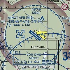
| Sectional chart |
|---|
|
 Download PDF
of official airport diagram from the FAA
| Airport distance calculator |
|---|
|
|
| Sunrise and sunset |
|---|
|
Times for 17-Jun-2026
| | Local
(UTC-5) | | Zulu
(UTC) |
|---|
| Morning civil twilight | | 05:02 | | 10:02 |
| Sunrise | | 05:44 | | 10:44 |
| Sunset | | 21:48 | | 02:48 |
| Evening civil twilight | | 22:30 | | 03:30 |
|
| Current date and time |
|---|
| Zulu (UTC) | 17-Jun-2026 22:10:15 |
|---|
| Local (UTC-5) | 17-Jun-2026 17:10:15 |
|---|
|
| METAR |
|---|
| KMIB | 172155Z 31012KT 10SM BKN095 17/12 A2958 RMK LTG DSNT NW SLP022 T01700115
|
KMOT
11nm S | 172154Z AUTO 30011KT 10SM -RA FEW050 BKN070 16/12 A2962 RMK AO2 RAB13 SLP031 P0000 T01610117
|
|
| TAF |
|---|
| KMIB | 171807Z 1718/1823 32010G20KT 9999 BKN030 BKN075 610809 QNH2946INS TEMPO 1718/1720 BKN019 BECMG 1719/1720 32010G20KT 9000 -SHRA VCTS SCT030 BKN040CB QNH2950INS TEMPO 1722/1801 -TSRA BKN030CB BECMG 1801/1802 VRB06KT 9999 NSW SCT045 BKN060 QNH2964INS BECMG 1814/1815 31009KT 9999 SCT040 OVC055 610805 QNH2979INS BECMG 1817/1818 30010G20KT 9000 -SHRA VCTS BKN060CB OVC070 QNH2977INS TEMPO 1820/1823 30015G25KT 6000 -TSRA TX18/1718Z TN08/1809Z
|
KMOT
11nm S | 171729Z 1718/1818 32012G20KT 6SM -SHRA SCT025 BKN035 PROB30 1718/1721 4SM -TSRA BKN025CB FM172100 34012G20KT 6SM -SHRA SCT035 BKN070 PROB30 1721/1724 4SM -TSRA BKN035CB FM180000 35013KT P6SM FEW040 SCT060 PROB30 1800/1802 4SM -SHRA BKN040 FM180200 31009KT P6SM SCT030 BKN090
|
|
| NOTAMs |
|---|
NOTAMs are issued by the DoD/FAA and will open in a separate window not controlled by AirNav.
|
|


